 view gallery view gallery SW38.3 km SW38.3 km
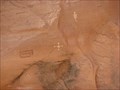
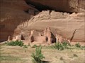
|   Pictographs at White House Ruins -Canyon de Chelly Pictographs at White House Ruins -Canyon de Chelly
in Pictographs Geometric and anthropomorphic pictographs on a cliff face dating from about 1200 A.D. posted by:  linkys linkys location: Arizona date approved: 11/02/2009 last visited: 01/01/2021 |
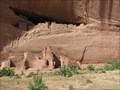 view gallery view gallerySW38.3 km |  White House Ruins - Canyon de Chelly White House Ruins - Canyon de Chelly
in New World Ancient Evidence These ruins date from about 1200 and are some of the oldest in the canyon. posted by: linkys location: Arizona date approved: 11/02/2009 last visited: 01/01/2021 |
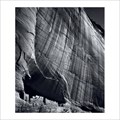 view gallery view gallerySW38.3 km |  White House Ruins, Canyon de Chelly, AZ White House Ruins, Canyon de Chelly, AZ
in Ansel Adams Photo Hunt White House Ruins, Canyon de Chelly, AZ - posted by: 05auditt location: Arizona date approved: 05/26/2013 last visited: 01/01/2021 |
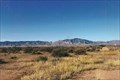
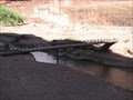 view gallery view gallerySW38.5 km |  White House Ruins Trail Footbridge - Canyon de Chelly White House Ruins Trail Footbridge - Canyon de Chelly
in Hiking Path Footbridges A nice footbridge near the White House Ruins in Canyon de Chelly National Monument. posted by: linkys location: Arizona date approved: 10/30/2009 last visited: 03/06/2019 |
 view gallery view gallerySW38.9 km |  White House Tail - Canyon de Chelly White House Tail - Canyon de Chelly
in Scenic Hikes A 1.5 mile trail that leads down into Canyon de Chelly National Monument and terminates at the White House ruins. posted by: linkys location: Arizona date approved: 10/29/2009 last visited: 01/01/2021 |
 view gallery view gallerySW40.4 km |  Canyon de Chelly National Monument Canyon de Chelly National Monument
in Wikipedia Entries A small National Monument preserving Navajo ruins in a series of canyons. posted by:  ChapterhouseInc ChapterhouseInc location: Arizona date approved: 11/20/2010 last visited: 02/15/2022 |
 view gallery view gallerySW40.4 km |  Canyon de Chelly National Monument Canyon de Chelly National Monument
in National Parks of the World A small National Monument preserving Navajo ruins in a series of canyons. posted by: ChapterhouseInc location: Arizona date approved: 11/21/2010 last visited: 01/01/2021 |
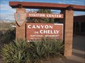
 view gallery view gallerySW40.4 km |  Visitor Center - Canyon de Chelly National Monument Visitor Center - Canyon de Chelly National Monument
in Tourist Information Centers - Visitor Centers Visitor Center, located at the head of the Canyon de Chelly canyon system. posted by: linkys location: Arizona date approved: 10/30/2009 last visited: 02/15/2022 |
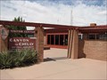
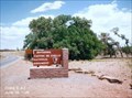
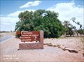
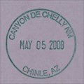 view gallery view gallerySW40.4 km |  Canyon de Chelly National Monument - Chinle, AZ Canyon de Chelly National Monument - Chinle, AZ
in NPS Passport Cancellation Stations Passport Station in the visitors center at the head of the canyon. posted by: linkys location: Arizona date approved: 11/30/2009 last visited: 02/15/2022 |
 view gallery view gallerySW40.4 km |  Female Hogan -- Canyon de Chelly Visitor Center, Chinle AZ Female Hogan -- Canyon de Chelly Visitor Center, Chinle AZ
in Octagon Buildings An eight-sided Navajo Female Hogan has been recreated and is on display at the Canyon de Chelly Visitor Center posted by: Benchmark Blasterz location: Arizona date approved: 08/23/2014 last visited: 03/06/2019 |
 view gallery view gallerySW40.6 km |  Canyon de Chelly National Monument - Chinle, AZ Canyon de Chelly National Monument - Chinle, AZ
in U.S. National Register of Historic Places Canyon de Chelly National Monument was established on April 1, 1931, as a unit of the National Park Service. Located in northeastern Arizona, it is within the boundaries of the Navajo Nation and lies in the Four Corners region. posted by: Don.Morfe location: Arizona date approved: 02/19/2022 last visited: 02/16/2022 |
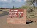 view gallery view gallerySW40.7 km | ") Canyon de Chelly National Monument - Chinle, AZ Canyon de Chelly National Monument - Chinle, AZ
in National Parks (U.S.) National Monument on Navajo Lands in northeastern Arizona that preserves ruins of Native American villages built in steep-walled canyons between A.D. 350 and 1300. posted by: linkys location: Arizona date approved: 11/22/2009 last visited: 02/15/2022 |
 view gallery view gallerySW40.7 km |  Canyon de Chelly National Monument - Chinle, AZ Canyon de Chelly National Monument - Chinle, AZ
in Official Local Tourism Attractions Canyon de Chelly National Monument was established on April 1, 1931, as a unit of the National Park Service. Located in northeastern Arizona, it is within the boundaries of the Navajo Nation and lies in the Four Corners region. posted by: Don.Morfe location: Arizona date approved: 02/15/2022 last visited: 02/15/2022 |
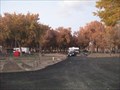
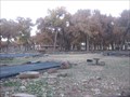 view gallery view gallerySW40.9 km |  Canyon de Chelly National Monument Canyon de Chelly National Monument
in Free Campsites This National Monument has a large campgroud free to tents and RVs alike. posted by: ChapterhouseInc location: Arizona date approved: 11/21/2010 last visited: 03/06/2019 |
 view gallery view gallerySW40.9 km | Canyon de Chelly National Monument in Campgrounds This National Monument has a large campgroud free to tents and RVs alike. posted by: ChapterhouseInc location: Arizona date approved: 11/24/2010 last visited: 03/06/2019 |
 view gallery view gallerySW40.9 km |  Canyon de Chelly National Monument Canyon de Chelly National Monument
in Free Overnight RV Parking Locations This National Monument has a large campgroud free to tents and RVs alike. posted by: ChapterhouseInc location: Arizona date approved: 11/22/2010 last visited: 03/06/2019 |
 view gallery view gallerySW41.2 km |  Kingdom Hall of Jehovah's Witnesses -- Chinle AZ Kingdom Hall of Jehovah's Witnesses -- Chinle AZ
in Kingdom Halls of Jehovah's Witnesses A Kingdom Hall of Jehovah's Witnesses on Indian Route 7, heading east out of Chinle AZ toward Canyon de Chelly posted by: Benchmark Blasterz location: Arizona date approved: 08/23/2014 last visited: 08/26/2014 |
 view gallery view gallerySW42.6 km |  Burger King - Highway 191 - Chinle, AZ Burger King - Highway 191 - Chinle, AZ
in Burger King Restaurants Burger Restaurant - Highway 191, Chinle, AZ 86503 posted by: walkingwildly location: Arizona date approved: 08/19/2015 last visited: 10/31/2015 |
 view gallery view gallery NE46 km NE46 km
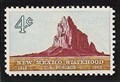
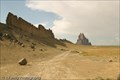
|  Ship Rock, New Mexico Ship Rock, New Mexico
in Philatelic Photographs The iconic landform known as Ship Rock is shown on this 1962 stamp celebrating 50 years of New Mexico statehood. posted by: hykesj location: New Mexico date approved: 07/13/2018 last visited: 03/04/2019 |
 view gallery view galleryNE46.2 km |  Shiprock along Rte 666 - Shiprock, NM Shiprock along Rte 666 - Shiprock, NM
in Satellite Imagery Oddities Shiprock is an exposed volcanic neck towering 1400ft above the surrounding plain, accompanied by radiating dikes. It was designated a U.S. National Natural Landmark in May 1975. posted by: DopeyDuck location: New Mexico date approved: 09/19/2009 last visited: 03/04/2019 |
 view gallery view galleryNE46.2 km |  Shiprock - Shiprock, NM Shiprock - Shiprock, NM
in U.S. National Natural Landmarks Shiprock is significant in the Navajo religion & mythology and was designated a U.S. National Natural Landmark in May 1975. The parking coords takes you up close and personal to the radiating dike in a roadcut along Red Rock Hwy. posted by: DopeyDuck location: New Mexico date approved: 06/15/2009 last visited: 03/04/2019 |
 view gallery view gallery N49.9 km N49.9 km
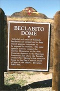
|  Beclabito Dome Beclabito Dome
in New Mexico Historical Markers Leaving four corners, this marker is just across the AZ-NM border. posted by: YoSam. location: New Mexico date approved: 03/06/2009 last visited: 03/06/2019 |
 view gallery view galleryN49.9 km | Beclabito Dome - Beclabito, NM in Satellite Imagery Oddities Baclabito, or Navajo Name is Bitl''aa bito (Water Beneath), is a pink sandstone mounds (peak) that really stands out. posted by: YoSam. location: New Mexico date approved: 12/03/2013 last visited: 03/06/2019 |
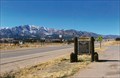
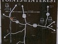 view gallery view galleryN49.9 km |  Beclabito Dome - San Juan County, NM Beclabito Dome - San Juan County, NM
in 'You Are Here' Maps You are here, identifies you spot on the hwy and in line to very the dome. posted by: YoSam. location: New Mexico date approved: 11/30/2013 last visited: 03/06/2019 |
 view gallery view galleryN49.9 km |  Beclabito Dome - Beclabito, NM Beclabito Dome - Beclabito, NM
in Places of Geologic Significance Formation cause by magma rising, but not breaking through posted by: YoSam. location: New Mexico date approved: 04/04/2019 last visited: never |
|