  SW6.4 km SW6.4 km
|   A Quick Tour of LaFollette! A Quick Tour of LaFollette!
in Geocaching Tour Guides If you are in the LaFollette, Jacksboro, or Caryville area and would like a local guide lemme know! posted by:  ridgesoarer ridgesoarer location: Tennessee date approved: 09/14/2005 last visited: 01/03/2009 |
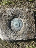
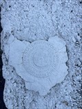 view gallery view gallerySW7.2 km |  63 5 (GB0606) LaFollette - Campbell County, TN 63 5 (GB0606) LaFollette - Campbell County, TN
in U.S. Benchmarks An easy to spot Tennessee Highway Department survey disk in LaFollette, TN. Parking right next to it. posted by: Team Geologynut location: Tennessee date approved: 05/03/2023 last visited: never |
 view gallery view gallery W7.4 km W7.4 km
|  Big Creek Gap-Natural Opening - LaFollette TN Big Creek Gap-Natural Opening - LaFollette TN
in Civil War Discovery Trail Sites The road in front of you winds through Big Creek Gap, one of the few natural openings through the Cumberland Mountains in the region. During the Civil War, this corridor was much narrower and steeper. posted by:  Don.Morfe Don.Morfe location: Tennessee date approved: 06/09/2020 last visited: 10/06/2021 |
 view gallery view galleryW7.4 km | Big Creek Gap-Natural Opening - LaFollette TN in U.S. Civil War Sites East Tennessee citizens who supported the Union alerted Federal commanders to the possibility of flanking the fortifications via Big Creep Gap. posted by: Don.Morfe location: Tennessee date approved: 05/28/2023 last visited: 05/28/2023 |
 view gallery view galleryW7.4 km |  Big Creek Gap - LaFollette TN Big Creek Gap - LaFollette TN
in Battlefields After a rigorous march, a detachment of Union soldiers, including a company of Campbell County men under Capt. Joseph A. Cooper, first penetrated the narrow passage here in March 1862 and routed the Confederate cavalry posted nearby. posted by: Don.Morfe location: Tennessee date approved: 05/28/2023 last visited: 05/28/2023 |
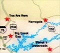
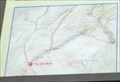 view gallery view galleryW7.4 km |  You Are Here Maps-Big Creek Gap-Natural Opening - LaFollette TN You Are Here Maps-Big Creek Gap-Natural Opening - LaFollette TN
in 'You Are Here' Maps The You Are Here Map shows that you are at the Cumberland Trail Trailhead at the intersection of North Tennessee Avenue and North Indiana Avenue (U.S. 25W), La Follette TN posted by: Don.Morfe location: Tennessee date approved: 05/28/2023 last visited: 05/28/2023 |
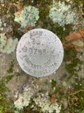 view gallery view gallerySW12.6 km | ACHW23 Oak Ridge Property Corner - Campbell Co. TN in U.S. Benchmarks Oak Ridge property corner marker 99738 posted by: TNnomad location: Tennessee date approved: 06/03/2021 last visited: never |
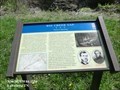
 view gallery view gallerySW15 km |  Campbell County Courthouse - Jacksboro, TN Campbell County Courthouse - Jacksboro, TN
in Courthouses Campbell County Courthouse in Jacksboro, TN posted by: Team Geologynut location: Tennessee date approved: 05/09/2023 last visited: never |
 view gallery view gallerySW15.1 km | 25 18 (GB0811) - Jacksboro - Campbell County, TN in U.S. Benchmarks An easy to spot Tennessee Highway Department survey disk in Jacksboro, TN. If you're lucky you can park next to it. I parked across the street. posted by: Team Geologynut location: Tennessee date approved: 05/03/2023 last visited: never |
 view gallery view galleryW17.7 km |  Huge Cross - Pioneer, TN Huge Cross - Pioneer, TN
in Christian Crosses Alongside I-75 near Pioneer Tennessee, a huge, white 50' cross stands. There is no signage or any other indication of who erected the cross or whose property it stands on. posted by: onfire4jesus location: Tennessee date approved: 07/26/2008 last visited: 08/23/2015 |
 view gallery view galleryW17.7 km |  Huge Cross - Pioneer, TN Huge Cross - Pioneer, TN
in Roadside Attractions This huge cross is located just off I-75 in Pioneer, TN. There is no signage indicating who erected it or who owns the property it is on. posted by: onfire4jesus location: Tennessee date approved: 07/25/2008 last visited: 08/23/2015 |
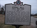 view gallery view gallerySW18.3 km |  Stone Mill - 1D37 - Caryville, TN Stone Mill - 1D37 - Caryville, TN
in Tennessee Historical Markers The grist mill served the area until Norris Lake was formed by TVA posted by: vhasler location: Tennessee date approved: 02/16/2009 last visited: 11/03/2012 |
 view gallery view gallerySW18.5 km |  US25W at Cove Lake State Park - Caryville, TN US25W at Cove Lake State Park - Caryville, TN
in Blue Star Memorial Highway Markers Blue Star Memorial tribute to Armed Forces by District IV TN Federation of Garden Clubs by entrance to Cove Lake State Park posted by: vhasler location: Tennessee date approved: 02/16/2009 last visited: never |
 view gallery view galleryW18.7 km | GB0560 (N 236) USC&GS Benchmark Disk - Campbell Co , TN in U.S. Benchmarks An easy to find USC&GS benchmark disk in Campbell County TN. posted by: Team Geologynut location: Tennessee date approved: 12/14/2020 last visited: never |
 view gallery view gallery E18.7 km E18.7 km
| U 132 (GA2347) - Speedwell, Claiborne County, TN in U.S. Benchmarks A USC&G benchmark set in a culvert headwall on Old Hwy 63 near Speedwell, TN. posted by: Team Geologynut location: Tennessee date approved: 05/03/2023 last visited: never |
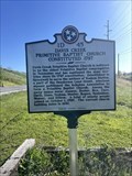 view gallery view galleryE18.8 km | Davis Creek Primitive Baptist Church Constituted 1797 1D 45 - Speedwell, Claiborne Co, TN in Tennessee Historical Markers A Tennessee Historical Commission Sign on Hwy 63 near Speedwell in Claiborne County, TN posted by: Team Geologynut location: Tennessee date approved: 05/03/2023 last visited: never |
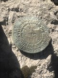 view gallery view galleryW19.2 km | GB0558 (F 236) USC&GS Benchmark Disk - Royal Blue, Campbell Co , TN in U.S. Benchmarks An easy to find USGS benchmark disk in the Royal Blue area of Campbell County TN. posted by: Team Geologynut location: Tennessee date approved: 01/08/2021 last visited: never |
 view gallery view gallerySW19.8 km |  Honey Bee at Owens Shoe Store-Caryville, TN Honey Bee at Owens Shoe Store-Caryville, TN
in Painted Barn Quilts Honey Bee quilt pattern is located at 195 Main Street. posted by: Countrydragon location: Tennessee date approved: 11/24/2009 last visited: 11/25/2009 |
 view gallery view gallerySW20.3 km |  Notch Falls - Caryville, TN Notch Falls - Caryville, TN
in Waterfalls This small, but beautiful waterfall is named Notch Falls. It is fed by Falls Creek. posted by: onfire4jesus location: Tennessee date approved: 01/30/2013 last visited: 12/31/2018 |
 view gallery view gallery NE20.6 km NE20.6 km
| Star Flower Wreath at Heck Farm-Speedwell,TN in Painted Barn Quilts Star Flower Wreath located on Hopper Circle off Hwy 63 in Speedwell. posted by: Countrydragon location: Tennessee date approved: 11/26/2009 last visited: 11/27/2009 |
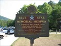 view gallery view gallery N20.6 km N20.6 km
| I-75 SB - near Jellico, TN in Blue Star Memorial Highway Markers A tribute to the Armed Forces that have defended the United states of America posted by: GA H2OBUG location: Tennessee date approved: 06/15/2007 last visited: 06/06/2018 |
 view gallery view galleryN20.6 km | Civil War in Tennessee-War in the Mountains - Jellico TN in Civil War Discovery Trail Sites Tennessee’s mountain residents were bitterly divided about secession in 1861, although most were Unionist. posted by: Don.Morfe location: Tennessee date approved: 06/01/2020 last visited: 10/06/2021 |
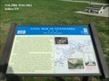 view gallery view galleryN20.6 km | Civil War in Tennessee-War in the Mountains - Jellico TN in U.S. Civil War Sites Tennessee’s mountain residents were bitterly divided about secession in 1861, although most were Unionist. In Huntsville, Scott County residents voted to secede and join Kentucky if Tennessee joined the Confederacy. posted by: Don.Morfe location: Tennessee date approved: 05/28/2023 last visited: 05/28/2023 |
 view gallery view galleryN20.6 km | You Are Here Map-Civil War in Tennessee-War in the Mountains - Jellico TN in 'You Are Here' Maps The You Are Here map shows that you are in front of the Tennessee Welcome Center on Interstate 75 in Jellico, Tennessee. posted by: Don.Morfe location: Tennessee date approved: 05/27/2023 last visited: 05/27/2023 |
 view gallery view galleryN20.8 km |  Tennessee/Kentucky Border on Interstate Highway 75 Tennessee/Kentucky Border on Interstate Highway 75
in Border Crossings You cross the Tennessee/Kentucky border travelling on Interstate Highway 75 between Jellico in Tennessee and Williamsburg in Kentucky. posted by: brwhiz location: Kentucky date approved: 07/04/2013 last visited: 02/25/2017 |
|