 view gallery view gallery SW9 km SW9 km
|   F 4 (GC1415) - Ashland City, Cheatham Co, TN F 4 (GC1415) - Ashland City, Cheatham Co, TN
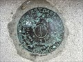
in U.S. Benchmarks An easy to find USC&G benchmark disk mounted at the entrance to the Cheatham County Courthouse. posted by:  Team Geologynut Team Geologynut location: Tennessee date approved: 10/24/2023 last visited: never |
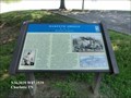
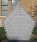
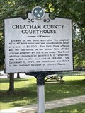 view gallery view gallerySW9 km |  Cheatham County Courthouse 3C 60 - Ashland City, TN Cheatham County Courthouse 3C 60 - Ashland City, TN
in Tennessee Historical Markers A Tennessee Historical Commission marker on the Cheatham County Courthouse lawn in Ashland City. posted by: Team Geologynut location: Tennessee date approved: 07/13/2023 last visited: never |
 view gallery view gallery NE10.8 km NE10.8 km
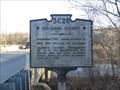
| Davidson County/Robertson County - 3 C 28 in Tennessee Historical Markers Two sided Tennessee Historical Commission marker 3 C 28 - Davidson County/Robertson County. Located along Hwy 431 at the border of Davidson County and Robertson County.
posted by: LSUMonica location: Tennessee date approved: 03/20/2007 last visited: 03/04/2007 |
 view gallery view gallery N13.8 km N13.8 km
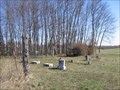
|  Lipscomb Cemetery Lipscomb Cemetery
in Worldwide Cemeteries Small cemetery located in Robertson County, Tennessee near Flewellyn and Sandy Springs. posted by: LSUMonica location: Tennessee date approved: 03/20/2007 last visited: 03/04/2007 |
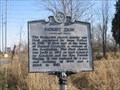 view gallery view galleryN14.2 km | Mount Zion - 3 C 26 in Tennessee Historical Markers Tennessee Historical Commission marker 3 C 26 - Mount Zion. Located at the junctions of Hwys 257 and 49 near Flewellyn, TN. posted by: LSUMonica location: Tennessee date approved: 03/05/2007 last visited: 03/04/2007 |
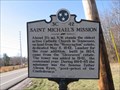 view gallery view galleryN14.3 km | St Michael's Mission - 3 C 42 in Tennessee Historical Markers Tennessee Historical Commission marker 3 C 42 - Saint Michael's Mission. Located at the intersection of Hwys 49 and 257 near Flewellyn, TN. posted by: LSUMonica location: Tennessee date approved: 03/05/2007 last visited: 03/04/2007 |
 view gallery view gallery W14.3 km W14.3 km
|  Harpeth Shoals-Hazardous Navigation - Charlotte TN Harpeth Shoals-Hazardous Navigation - Charlotte TN
in Civil War Discovery Trail Sites Federal forces gained control of Nashville and transported most of their supplies to the city via the Cumberland River. Extending for five miles along the river here, the Harpeth Shoals made navigation hazardous. posted by:  Don.Morfe Don.Morfe location: Tennessee date approved: 05/11/2020 last visited: 10/08/2021 |
 view gallery view galleryW14.3 km |  Harpeth Shoals - Charlotte TN Harpeth Shoals - Charlotte TN
in Battlefields On January 13, 1863, Confederate Gen. Joseph Wheeler’s cavalry established positions nearby (Harpeth Shoals) and ambushed Union ships. Wheeler’s men destroyed two Union hospital ships, USS Trio and Parthenia, and one gunboat before retiring. posted by: Don.Morfe location: Tennessee date approved: 05/10/2023 last visited: 05/10/2023 |
 view gallery view galleryW14.3 km | Harpeth Shoals-Hazardous Navigation - Charlotte TN in U.S. Civil War Sites On January 13, 1863, Confederate Gen. Joseph Wheeler’s cavalry established positions nearby (Harpeth Shoals) and ambushed Union ships. Wheeler’s men destroyed two Union hospital ships, USS Trio and Parthenia, and one gunboat before retiring. posted by: Don.Morfe location: Tennessee date approved: 05/11/2023 last visited: 05/12/2023 |
 view gallery view gallery SE17.1 km SE17.1 km
|  Whites Creek, TN, 37189 Whites Creek, TN, 37189
in U.S. Post Offices Post office for White Creek, TN located along Whites Creek Pike. posted by: LSUMonica location: Tennessee date approved: 03/23/2007 last visited: 02/11/2007 |
 view gallery view gallery NW19.8 km NW19.8 km
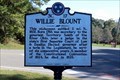
| Willie Blount - 3C 17 - Clarksville, TN in Tennessee Historical Markers Located on US Alternate 41 at Mt. Carmel Road, Clarksville posted by: Markerman62 location: Tennessee date approved: 11/10/2021 last visited: never |
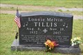 view gallery view galleryNW20.4 km |  Lonnie Melvin Tillis - Clarksville, Tennessee Lonnie Melvin Tillis - Clarksville, Tennessee
in Grave of a Famous Person Mel Tillis is a member of both the Country Music Hall of Fame and the Song Writers Hall of Fame along with being a member of the Grand Ole Opry. posted by: Sneakin Deacon location: Tennessee date approved: 12/08/2022 last visited: never |
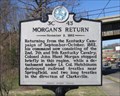 view gallery view galleryNE21.2 km | Morgan's Return November 2, 1862 - 3 C 43 in Tennessee Historical Markers Tennessee Historical Commission marker 3 C 43 - Morgan's Return November 2, 1862. Located along Hwy 41 in Springfield, TN. posted by: LSUMonica location: Tennessee date approved: 03/19/2007 last visited: 10/02/2008 |
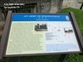 view gallery view galleryNE21.6 km | An Army In Springfield-Federal Occupation - Springfield TN in U.S. Civil War Sites After the fall of Confederate Forts Henry and Donelson in 1862, Union forces occupied the county and made the town of Springfield a military base, where they guarded local roads and the Edgefield and Kentucky Railroad. posted by: Don.Morfe location: Tennessee date approved: 06/19/2023 last visited: 06/19/2023 |
 view gallery view galleryNE21.6 km |  You Are Here Maps-An Army In Springfield - Springfield TN You Are Here Maps-An Army In Springfield - Springfield TN
in 'You Are Here' Maps The You Are Here Map show that you are at South Brown Street
Springfield, TN. posted by: Don.Morfe location: Tennessee date approved: 06/12/2023 last visited: 06/12/2023 |
 view gallery view galleryNE21.6 km | An Army In Springfield-Federal Occupation - Springfield TN in Civil War Discovery Trail Sites After the fall of Confederate Forts Henry and Donelson in 1862, Union forces occupied the county and made the town of Springfield a military base, where they guarded local roads and the Edgefield and Kentucky Railroad. posted by: Don.Morfe location: Tennessee date approved: 06/27/2020 last visited: 09/24/2021 |
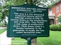 view gallery view galleryNE21.6 km | Springfield Historic District - Springfield TN in Tennessee Historical Markers This area is a city designated residential historic district. Although settled in 1796; the existing homes in this neighborhood date from 1833. They include a wide range of architectural styles. posted by: Don.Morfe location: Tennessee date approved: 10/18/2020 last visited: 09/24/2021 |
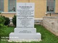
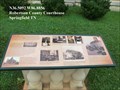 view gallery view galleryNE21.7 km |  Robertson County Courthouse - Springfield TN Robertson County Courthouse - Springfield TN
in Signs of History Robertson County was established April 9, 1796, during the first session of the General Assembly of Tennessee. The act provided commissioners to establish the county government system and raise money to build a courthouse and jail. posted by: Don.Morfe location: Tennessee date approved: 10/28/2020 last visited: 09/24/2021 |
 view gallery view galleryNE21.7 km | Robertson County Courthouse - Springfield, TN in Signs of History History marker telling of the construction of the very nearby county courthouse. posted by: thegorilla23 location: Tennessee date approved: 04/23/2015 last visited: 02/06/2023 |
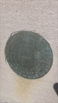 view gallery view galleryNE21.7 km | Springfield GC1018 - Springfield, TN in U.S. Benchmarks Benchmark marked SPRINGFIELD 1935 on the Robertson County Courthouse posted by: thegorilla23 location: Tennessee date approved: 04/04/2015 last visited: 03/28/2015 |
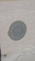 view gallery view galleryNE21.7 km | 680 GC1019 - Springfield, TN in U.S. Benchmarks Benchmark labeled 680 on the Robertson County Courthouse posted by: thegorilla23 location: Tennessee date approved: 04/04/2015 last visited: 03/28/2015 |
 view gallery view galleryNE21.7 km |  Robertson County WWII Memorial - Springfield, TN Robertson County WWII Memorial - Springfield, TN
in World War II Memorials / Monuments Memorial for those from Robertson County that served in World War II posted by: thegorilla23 location: Tennessee date approved: 04/22/2015 last visited: 04/27/2015 |
 view gallery view galleryNE21.7 km | Robertson County Courthouse - Springfield, TN in U.S. Benchmarks County courthouse tower serves as a benchmark posted by: thegorilla23 location: Tennessee date approved: 04/04/2015 last visited: 02/06/2023 |
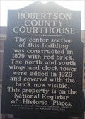
 view gallery view galleryNE21.7 km |  1879 - Robertson County Courthouse - Springfield, TN 1879 - Robertson County Courthouse - Springfield, TN
in Dated Buildings and Cornerstones County Courthouse built in 1879 posted by: thegorilla23 location: Tennessee date approved: 04/23/2015 last visited: 04/27/2015 |
 view gallery view galleryNE21.7 km | Fallen Confederate Soldiers In Memorium - Springfield TN in American Civil War Monuments and Memorials In Memorium Pro Artis et Focis (For hearth and home)
Fallen Confederate Soldiers in the War Between the States posted by: Don.Morfe location: Tennessee date approved: 06/27/2020 last visited: 09/24/2021 |
|