 view gallery view gallery SW5.6 km SW5.6 km
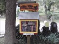
|   Little Free Library #4747 - War Eagle AR Little Free Library #4747 - War Eagle AR
in Free Community Book Exchanges This beautifully-crafted miniature "library", here in this very rural and remote location, is stocked full to the brim with books, all available on the "take a book - leave a book" basis. posted by:  Where's George Where's George location: Arkansas date approved: 08/21/2014 last visited: never |
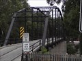 view gallery view gallerySW5.8 km |  War Eagle Bridge - Rogers AR War Eagle Bridge - Rogers AR
in U.S. National Register of Historic Places "The War Eagle Bridge, a one lane steel bridge built in 1907, adjoins the War Eagle Mill, and carries County Route 98 over War Eagle Creek. The bridge was listed on the National Register of Historic Places on November 19, 1985." posted by: Where's George location: Arkansas date approved: 07/14/2013 last visited: 05/20/2009 |
 view gallery view gallerySW5.8 km |  War Eagle Bridge - Rogers AR War Eagle Bridge - Rogers AR
in Truss Bridges "The War Eagle Bridge, a one lane steel bridge built in 1907, adjoins the War Eagle Mill, and carries County Route 98 over War Eagle Creek. The bridge was listed on the National Register of Historic Places on November 19, 1985." posted by: Where's George location: Arkansas date approved: 07/13/2013 last visited: 05/20/2009 |
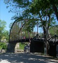 view gallery view gallerySW5.8 km |  War Eagle Bridge - rural Benton County, Arkansas War Eagle Bridge - rural Benton County, Arkansas
in Wikipedia Entries This 182 foot steel truss bridge is located near War Eagle Mill in rural Benton County, Arkansas. posted by:  iconions iconions location: Arkansas date approved: 08/05/2017 last visited: 06/10/2018 |
 view gallery view gallerySW5.8 km |  War Eagle Bridge - 1907 - War Eagle AR War Eagle Bridge - 1907 - War Eagle AR
in Bridge Date Stones and Plaques "The War Eagle Bridge, a one lane steel bridge built in 1907, adjoins the War Eagle Mill, and carries County Route 98 over War Eagle Creek. The bridge was listed on the National Register of Historic Places on November 19, 1985." posted by: Where's George location: Arkansas date approved: 07/18/2013 last visited: never |
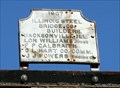
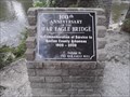 view gallery view gallerySW5.8 km |  War Eagle Bridge 100th Anniversary - War Eagle AR War Eagle Bridge 100th Anniversary - War Eagle AR
in Arkansas Historical Markers This plaque, celebrating the 100th anniversary of this bridge's service to the community, is located between the old mill, and the eastern approach to the bridge. posted by: Where's George location: Arkansas date approved: 07/17/2013 last visited: never |
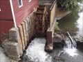 view gallery view gallerySW5.8 km |  War Eagle Mill Water Wheel - Rogers AR War Eagle Mill Water Wheel - Rogers AR
in Working Water Wheels War Eagle Mill’s 18-foot undershot water wheel rotates when water strikes the paddles or blades at the bottom of the wheel. posted by: Where's George location: Arkansas date approved: 07/14/2013 last visited: 08/30/2021 |
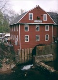 view gallery view gallerySW5.8 km | War Eagle Mill, Rogers, Arkansas in Water Mills War Eagle was best known as a lumbering center. In 1869 Peter VanWinkle settled nearby and built a large saw mill which supplied the lumber for numerous buildings in Northwest Arkansas, including University of Arkansas' Old Ma posted by: Montana Dave location: Arkansas date approved: 10/25/2006 last visited: 09/06/2015 |
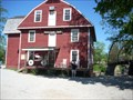 view gallery view gallerySW5.8 km | War Eagle Mill - rural Benton County, Arkansas in Wikipedia Entries This working water powered mill is located at 11045 War Eagle Road in rural Benton County, Arkansas. posted by: iconions location: Arkansas date approved: 08/05/2017 last visited: never |
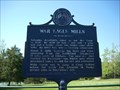 view gallery view gallerySW5.8 km | War Eagle Mills Marker - War Eagle, Ar in Arkansas Historical Markers This marker is north of the bridge and north of the War Eagle Mill. posted by: iconions location: Arkansas date approved: 05/28/2009 last visited: 07/10/2013 |
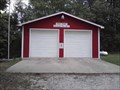
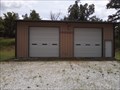
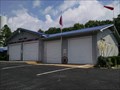
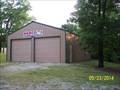 view gallery view gallery N5.8 km N5.8 km
|  NEBCO No. 5 NEBCO No. 5
in Firehouses One of 5 fire stations under the same administration in rural Benton County, Arkansas posted by: MountainWoods location: Arkansas date approved: 05/26/2014 last visited: 05/23/2014 |
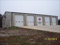
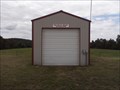 view gallery view gallerySW6.1 km | Piney Point Vol. Fire Dept. War Eagle Station in Firehouses This is one of three rural fire stations we found today in this backwoods area of northwest Arkansas. posted by: Where's George location: Arkansas date approved: 07/10/2013 last visited: never |
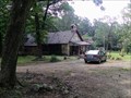
 view gallery view galleryN6.6 km |  Coal Gap School near Garfield, AR Coal Gap School near Garfield, AR
in Former Schools A beautifully-maintained former one-room school in Benton County, Arkansas posted by: MountainWoods location: Arkansas date approved: 05/23/2014 last visited: 05/23/2014 |
 view gallery view galleryN6.6 km | Coal Gap School in LaRue, AR in Wikipedia Entries A beautifully-maintained former one-room school in Benton County, Arkansas posted by: MountainWoods location: Arkansas date approved: 05/23/2014 last visited: 05/23/2014 |
 view gallery view galleryN6.6 km | Coal Gap School - LaRue, Arkansas in U.S. National Register of Historic Places A beautifully-maintained former one-room school in Benton County, Arkansas posted by: MountainWoods location: Arkansas date approved: 05/23/2014 last visited: 05/23/2014 |
 view gallery view galleryN6.6 km |  Coal Gap School - LaRue, AR Coal Gap School - LaRue, AR
in One-Room Schoolhouses A beautifully-maintained former one-room school in Benton County, Arkansas posted by: MountainWoods location: Arkansas date approved: 05/27/2014 last visited: 05/23/2014 |
 view gallery view gallerySW7.7 km | Piney Point Volunteer Fire Dept in Firehouses This is one of three rural fire stations we found today in this backwoods area of northwest Arkansas. posted by: Where's George location: Arkansas date approved: 07/10/2013 last visited: never |
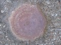
 view gallery view gallery NE9 km NE9 km
|  MUNDELL - AZIMUTH ARKANSAS MUNDELL - AZIMUTH ARKANSAS
in Azimuth Benchmarks MUNDELL AZIMUTH MARK BEAVER LAKE ARKANSAS posted by: GEO*Trailblazer 1 location: Arkansas date approved: 11/27/2007 last visited: 11/27/2007 |
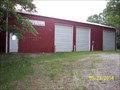 view gallery view gallery NW9.3 km NW9.3 km
| NEBCO No. 3 in Firehouses One of 5 fire stations under the same administration in rural Benton County, Arkansas posted by: MountainWoods location: Arkansas date approved: 05/26/2014 last visited: 05/23/2014 |
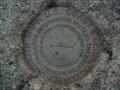
 view gallery view galleryNE9.7 km |  MUNDELL - TRIANGULATION STATION MUNDELL - TRIANGULATION STATION
in U.S. Benchmarks Designation: MUNDELL
Marker Type: Triangulation Station Disk
Setting: Set into the top of a round concrete monument posted by: GEO*Trailblazer 1 location: Arkansas date approved: 11/30/2007 last visited: 11/30/2007 |
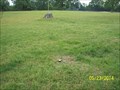 view gallery view galleryN10.5 km |  Highest Point in Benton Couny, Arkansas Highest Point in Benton Couny, Arkansas
in Geographic High Points The highest point in the northwest-most county in Arkansas posted by: MountainWoods location: Arkansas date approved: 05/27/2014 last visited: 05/26/2014 |
 view gallery view gallerySW11.7 km | Piney Point Fire Department in Firehouses This is one of three rural fire stations we found today in this backwoods area of northwest Arkansas. posted by: Where's George location: Arkansas date approved: 07/10/2013 last visited: never |
 view gallery view galleryN12.2 km | NEBCO Fire-EMS Station 2 in Firehouses One of 5 fire stations under the same administration in rural Benton County, Arkansas posted by: MountainWoods location: Arkansas date approved: 11/25/2013 last visited: 11/22/2013 |
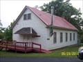
 view gallery view galleryNE12.4 km |  Grassy Knob Church - Eureka Springs, AR Grassy Knob Church - Eureka Springs, AR
in Country Churches A country church converted to a home in rural Carroll County, Arkansas posted by: MountainWoods location: Arkansas date approved: 06/13/2015 last visited: 06/12/2015 |
 view gallery view galleryNE12.6 km | Grassy Knob Volunteer Fire Association & Community Center in Firehouses A rural Arkansas fire station that also serves as the community center in Carroll County, Arkansas posted by: MountainWoods location: Arkansas date approved: 06/12/2015 last visited: 06/12/2015 |
|