 view gallery view gallery NW10.9 km NW10.9 km
|   Mos Eisley - Dante's View, Death Valley, California, USA Mos Eisley - Dante's View, Death Valley, California, USA
in All Things Star Wars Did you know that city of Mos Eisley on Tatooine is really in Badwater Basin? posted by:  netdust netdust location: California date approved: 01/04/2015 last visited: 04/07/2022 |
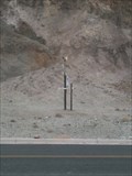
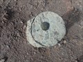 view gallery view galleryNW10.9 km |  NPS Survey Mark DV1 RESET - Dante's View - Death Valley National Park, CA NPS Survey Mark DV1 RESET - Dante's View - Death Valley National Park, CA
in U.S. Benchmarks An unmarked US National Park Service survey mark located just off the parking area of Dante's View in Death Valley National Park, replacing the vandalized DV1. posted by: jiggs11 location: California date approved: 04/20/2017 last visited: 02/09/2017 |
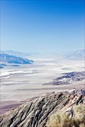
 view gallery view galleryNW10.9 km |  Dante's View - Death Valley National Park, CA, USA Dante's View - Death Valley National Park, CA, USA
in Wikipedia Entries This panoramic vista, known as Dante's View, is situated atop the Black Mountains and is considered to be one of the great photographic spots in Death Valley. posted by:  Chasing Blue Sky Chasing Blue Sky location: California date approved: 04/18/2013 last visited: 04/07/2022 |
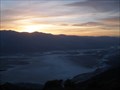 view gallery view galleryNW10.9 km |  Dante's View - Death Valley National Park, CA, USA Dante's View - Death Valley National Park, CA, USA
in Scenic Roadside Look-Outs This panoramic vista, known as Dante's View, is situated atop the Black Mountains and is considered to be one of the great photographic spots in Death Valley - and you can drive right to it. posted by: Chasing Blue Sky location: California date approved: 04/18/2013 last visited: 04/07/2022 |
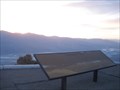
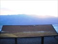 view gallery view galleryNW10.9 km |  Dante's View Orientation Table - Death Valley National Park, CA, USA Dante's View Orientation Table - Death Valley National Park, CA, USA
in Orientation Tables This Orientation Table is located on the panoramic vista, known as Dante's View, which is situated atop the Black Mountains and is considered to be one of the great photographic spots in Death Valley - and you can drive right to it. posted by: Chasing Blue Sky location: California date approved: 04/21/2013 last visited: 04/07/2022 |
 NW10.9 km | Death Valley National Park: D.V. 2 in U.S. Benchmarks Unspecified NPS marker near PID: GS0907 posted by: [DELETED_USER] location: California date approved: 03/31/2008 last visited: 04/07/2022 |
 view gallery view galleryNW10.9 km |  "Looking across desert toward mountains" - Death Valley, California, USA "Looking across desert toward mountains" - Death Valley, California, USA
in Ansel Adams Photo Hunt Ansel Adams took some great shots in Death Valley. posted by: netdust location: California date approved: 01/03/2015 last visited: 04/07/2022 |
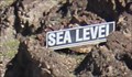 view gallery view galleryNW14.5 km |  Sea Level - Badwater Basin, Death Valley National Park CA Sea Level - Badwater Basin, Death Valley National Park CA
in Elevation Signs At Badwater Basin, a Sea Level sign high on the mountain directly east of the road lets you know how far below sea level you are. posted by: Benchmark Blasterz location: California date approved: 03/29/2016 last visited: 04/07/2022 |
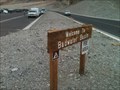
 view gallery view galleryNW14.6 km |  Best Kept Secret of Badwater Basin Best Kept Secret of Badwater Basin
in Best Kept Secrets Although the famous Bad Water Basin sign is here, there is a less famous sign that people miss while they visit here. All you have to do is look to the east, you will find it. The above coordinates are the best place to view this best kept secret. posted by: bluesnote location: California date approved: 04/09/2012 last visited: 04/07/2022 |
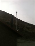
 view gallery view galleryNW14.6 km |  Lowest Weather Station in North America Lowest Weather Station in North America
in Weather Stations Welcome to the lowest weather station in North America! posted by: bluesnote location: California date approved: 02/24/2012 last visited: 01/05/2023 |
 view gallery view galleryNW14.6 km |  DESTINATION: Amargosa River - Badwater Basin DESTINATION: Amargosa River - Badwater Basin
in River Origins, Destinations and Confluences The Amargosa River mostly deposits all of the water here, but really, it is all the water from the surrounding mountains that come here to form a lake in the spring time, and a salty bottom in the winter, summer and fall. posted by: bluesnote location: California date approved: 02/21/2012 last visited: 01/05/2023 |
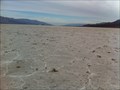
 view gallery view galleryNW14.6 km |  Badwater - Death Valley National Park, CA Badwater - Death Valley National Park, CA
in American Guide Series Badwater, the lowest terrestrial point in the western hemisphere is mentioned in the American Guide Series, California book. posted by: bluesnote location: California date approved: 07/30/2015 last visited: 04/07/2022 |
 view gallery view galleryNW14.6 km |  Badwater Basin - Death Valley National Park, CA Badwater Basin - Death Valley National Park, CA
in Satellite Imagery Oddities This is the lowest waymark in North America! posted by: bluesnote location: California date approved: 11/01/2014 last visited: 04/07/2022 |
 view gallery view gallery W14.6 km W14.6 km
|  Badwater Basin - Death Valley Scenic Byway - Death Valley National Park, CA Badwater Basin - Death Valley Scenic Byway - Death Valley National Park, CA
in National Scenic Byways This is the lowest waymark in North America! posted by: bluesnote location: California date approved: 02/22/2012 last visited: 04/07/2022 |
 view gallery view galleryNW14.6 km |  Badwater Basin - Death Valley National Park, CA Badwater Basin - Death Valley National Park, CA
in Official Local Tourism Attractions This is a must see location if you are in Death Valley National Park. posted by: bluesnote location: California date approved: 02/29/2012 last visited: 04/07/2022 |
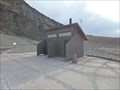 view gallery view galleryW14.6 km |  Western Hemisphere's Lowest Pit Toilet - Death Valley, CA Western Hemisphere's Lowest Pit Toilet - Death Valley, CA
in Roadside Attractions Pit toilets located at 282 Feet below sea level serving the needs of tourists in the Badwater Basin of Death Valley National Park! posted by: jiggs11 location: California date approved: 04/17/2017 last visited: 10/06/2017 |
 view gallery view galleryNW14.6 km | Badwater Basin - 282 Feet Below Sea Level - Death Valley National Park, CA in Elevation Signs This sign is located in Death Valley National Park. posted by: Team Min Dawg location: California date approved: 04/26/2010 last visited: 04/07/2022 |
 view gallery view galleryW14.6 km | Badwater Weather Station - Death Valley National Park, CA in Weather Stations This is the second lowest weather station in all of North America! posted by: bluesnote location: California date approved: 02/24/2012 last visited: 01/05/2023 |
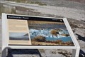 view gallery view galleryNW14.6 km |  Badwater Pool -- Badwater Basin, Death Valley National Park, CA Badwater Pool -- Badwater Basin, Death Valley National Park, CA
in Signs of History One of several interpretive signs at this fascinating area in Death Valley national Park. posted by: Benchmark Blasterz location: California date approved: 03/29/2016 last visited: 04/07/2022 |
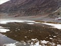 view gallery view galleryNW14.6 km |  Badwater Basin - Death Valley National Park, CA Badwater Basin - Death Valley National Park, CA
in Natural Lakes This lake is a seasonal lake that is here only during the late winter and spring time. posted by: bluesnote location: California date approved: 02/22/2012 last visited: 04/07/2022 |
 view gallery view galleryNW14.6 km | But It's a Dry Heat -- Death Valley National Park, CA in Signs of History One of several interpretive signs at this fascinating area in Death Valley National Park. posted by: Benchmark Blasterz location: California date approved: 03/31/2016 last visited: 04/07/2022 |
 view gallery view galleryNW14.6 km | Salt Flats -- Death Valley National Park, CA in Signs of History One of several interpretive signs at this fascinating area in Death Valley National Park. posted by: Benchmark Blasterz location: Texas date approved: 03/31/2016 last visited: 04/07/2022 |
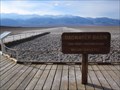
 view gallery view galleryNW14.6 km |  Badwater Basin - Death Valley National Park, CA Badwater Basin - Death Valley National Park, CA
in Hiking and walking trailheads This is the lowest waymark in North America! posted by: bluesnote location: California date approved: 04/11/2016 last visited: 04/07/2022 |
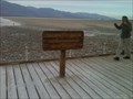
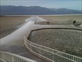 view gallery view galleryNW14.6 km |  Badwater Basin - Death Valley National Park, CA Badwater Basin - Death Valley National Park, CA
in Non-Coastal Boardwalks This is the lowest waymark in North America! posted by: bluesnote location: California date approved: 04/01/2016 last visited: 04/07/2022 |
 view gallery view galleryNW14.6 km | Badwater Basin - Death Valley National Park, CA in Scenic Roadside Look-Outs This is the lowest waymark in North America! posted by: bluesnote location: California date approved: 04/01/2016 last visited: 04/07/2022 |
|