 view gallery view gallery NE14.5 km NE14.5 km
|   Cameron, Arizona 86020 ~ Main Post Office Cameron, Arizona 86020 ~ Main Post Office
in U.S. Post Offices This Post Office is located at 465 US Highway 89 in Cameron, Arizona. posted by:  brwhiz brwhiz location: Arizona date approved: 09/05/2011 last visited: 09/11/2019 |
 view gallery view galleryNE14.5 km |  Cameron Trading Post Penny Smasher Cameron Trading Post Penny Smasher
in Penny Smashers This Penny Smasher is inside the Cameron Trading Post located at 466 N Highway 89 in Cameron, Arizona. posted by: brwhiz location: Arizona date approved: 06/25/2011 last visited: 03/20/2019 |
 view gallery view galleryNE14.5 km |  Kokopelli on Smashed Penny Kokopelli on Smashed Penny
in Kokopelli Sightings This Kokopelli is just barely visible on the second of four designs in a Penny Smasher in Cameron, Arizona. Take home your own Kokopelli and Grand Canyon Souvenir for only 51 cents! posted by: brwhiz location: Arizona date approved: 06/21/2011 last visited: 03/20/2019 |
 view gallery view galleryNE14.5 km |  Cameron Trading Post Gallery ~ Cameron, Arizona Cameron Trading Post Gallery ~ Cameron, Arizona
in Art Galleries The Cameron Trading Post Gallery is located in a complex on the west side of US Highway 89 on the south bank of the Little Colorado River. posted by: brwhiz location: Arizona date approved: 11/10/2012 last visited: 03/20/2019 |
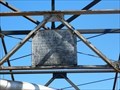
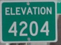 view gallery view galleryNE14.6 km |  Little Colorado River Bridge ~ Elevation 4204 Little Colorado River Bridge ~ Elevation 4204
in Elevation Signs The elevation of the US Highway 89 bridge across the Little Colorado River at Cameron, Arizona is 4204 feet. posted by: brwhiz location: Arizona date approved: 06/23/2011 last visited: 07/13/2017 |
 view gallery view galleryNE14.6 km |  Tanner's Crossing of The Mormon Trail - Cameron, AZ Tanner's Crossing of The Mormon Trail - Cameron, AZ
in Wagon Roads and Trails This suspension bridge marks the area of Tanner's Crossing of the Little Colorado River on The Mormon Trail from Utah via Lee Ferry to settlements in Arizona and Mexico. posted by:  DopeyDuck DopeyDuck location: Arizona date approved: 09/29/2008 last visited: 08/17/2022 |
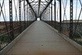 view gallery view galleryNE14.6 km |  Historic Tanner's Crossing Bridge - Cameron, AZ Historic Tanner's Crossing Bridge - Cameron, AZ
in Orphaned Bridges This suspension bridge was built in 1911 by the Midland Bridge Co. for the Office of Indian Affairs. It is also a Natl Historic Place. The one-lane bridge is closed to vehicles now, but appears to carry an oil pipeline. posted by: DopeyDuck location: Arizona date approved: 09/29/2008 last visited: 08/17/2022 |
 view gallery view galleryNE14.6 km |  Little Colorado River Bridge - Cameron, AZ Little Colorado River Bridge - Cameron, AZ
in Suspension Bridges This suspension bridge was built in 1911 by the Midland Bridge Co. for the Office of Indian Affairs. The one-lane bridge is closed to vehicles now, but appears to carry an oil pipeline. It is also a Natl Historic Place. posted by: DopeyDuck location: Arizona date approved: 09/29/2008 last visited: 08/17/2022 |
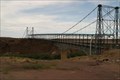 view gallery view galleryNE14.6 km |  Cameron Suspension Bridge - Cameron, AZ Cameron Suspension Bridge - Cameron, AZ
in U.S. National Register of Historic Places This suspension bridge was built in 1911 after danger of flooding and quicksand at Tanner's Crossing of The Mormon Trail. It was a one-lane bridge for vehicles, but now only carries an oil pipeline. posted by: DopeyDuck location: Arizona date approved: 09/30/2008 last visited: 08/17/2022 |
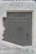 view gallery view galleryNE14.6 km |  Cameron AZ Marker - Cameron, AZ Cameron AZ Marker - Cameron, AZ
in Arizona Historical Markers This marks the area of Tanner's Crossing of the Little Colorado River on the Mormon Trail. posted by: DopeyDuck location: Arizona date approved: 10/05/2008 last visited: 08/17/2022 |
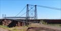 view gallery view galleryNE14.6 km |  Cameron Suspension Bridge - Cameron, AZ Cameron Suspension Bridge - Cameron, AZ
in Wikipedia Entries This historic, one lane, suspension bridge, now decommissioned and carrying a pipeline, is located next to US-89 and north of the Cameron Trading Post. posted by: iconions location: Arizona date approved: 09/12/2019 last visited: 08/17/2022 |
 view gallery view galleryNE14.6 km |  Cameron Suspension Bridge - 1911 - Cameron, AZ Cameron Suspension Bridge - 1911 - Cameron, AZ
in Bridge Date Stones and Plaques This historic, one lane, suspension bridge, now decommissioned and carrying a pipeline, is located next to US-89 and north of the Cameron Trading Post. posted by: iconions location: Arizona date approved: 10/10/2019 last visited: 08/17/2022 |
 view gallery view gallery N14.8 km N14.8 km
|  High-Wire Walk across Grand Canyon High-Wire Walk across Grand Canyon
in News Article Locations Daredevil Nik Wallenda completed a historic high-wire walk over a section of the Grand Canyon on June, 23, 2013. posted by: Bernd das Brot Team location: Arizona date approved: 06/24/2013 last visited: never |
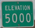 view gallery view galleryN16.4 km | Arizona Highway 64 ~ Elevation 5000 in Elevation Signs Arizona Highway 64 passes through the 5000 foot level between the east entrance to Grand Canyon National Park at Desert View and the junction with US Highway 89 near Cameron. posted by: brwhiz location: Arizona date approved: 06/23/2011 last visited: 03/20/2019 |
 view gallery view galleryN17.2 km |  Little Colorado River Gorge Navajo Tribal Park - Cameron AZ Little Colorado River Gorge Navajo Tribal Park - Cameron AZ
in Scenic Overlooks This Navajo Tribal Park offers visitors a fantastic view of the deep narrow gorge of the Little Colorado River. posted by: Don.Morfe location: Arizona date approved: 12/07/2020 last visited: 10/23/2021 |
 view gallery view gallery S21.9 km S21.9 km
|  Wupatki National Monument - Box Canyon and Lomatki Pueblo Wupatki National Monument - Box Canyon and Lomatki Pueblo
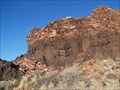
in National Parks of the World The Box Canyon and Lomatki Pueblo Ruins are located in Wupatki National Monument. A short dirt path leads to the ruins from the parking lot. posted by: TerryDad2 location: Arizona date approved: 08/24/2006 last visited: 04/11/2017 |
 view gallery view galleryS21.9 km |  Box Canyon and Lomatki Pueblo Box Canyon and Lomatki Pueblo
in New World Ancient Evidence The Box Canyon and Lomatki Pueblo Ruins are located in Wupatki National Monument. A short dirt path leads to the ruins from the parking lot. posted by: TerryDad2 location: Arizona date approved: 07/26/2006 last visited: 04/11/2017 |
 view gallery view gallery NW22.4 km NW22.4 km
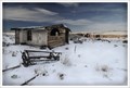
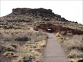
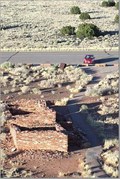
|  Begay Family Structures - Near the Grand Canyon NP, AZ Begay Family Structures - Near the Grand Canyon NP, AZ
in Unoccupied Buildings, Shacks, and Cabins Located behind a Navajo trading area close to the Grand Canyon. There are three or four buildings that belonged to the Begay family at one time. They sell trinkets just outside and with permission, they will allow photographs posted by: terraphoto location: Arizona date approved: 09/23/2009 last visited: 03/20/2019 |
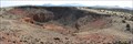 view gallery view galleryS23.2 km |  Citadel Sinkhole - Wupatki National Monument, Flagstaff, AZ Citadel Sinkhole - Wupatki National Monument, Flagstaff, AZ
in Natural Sinkholes A huge sinkhole located behind an ancient native American pueblo in Wuptaki National Monument near Flagstaff, Arizona. posted by: Rayman location: Arizona date approved: 04/08/2010 last visited: 08/06/2022 |
 view gallery view galleryS23.2 km |  Nalakihu Ruins - Wupatki National Monument, Flagstaff, AZ Nalakihu Ruins - Wupatki National Monument, Flagstaff, AZ
in American Guide Series The Nalakihu and Teuwalanki ruins are two sets of ruin groups located within Wupatki National Park. posted by: Rayman location: Arizona date approved: 04/25/2010 last visited: 04/10/2023 |
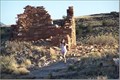
 view gallery view galleryS23.2 km | Citidel Pueblo in New World Ancient Evidence The Citadel Pueblo sits on a bluff beside a large sinkhole in Wupatki National Monument. posted by: TerryDad2 location: Arizona date approved: 07/26/2006 last visited: 04/10/2023 |
 view gallery view galleryS23.2 km | Wupatki National Monument - Citadel Pueblo in National Parks of the World The Citadel Pueblo sits on a bluff beside a large sinkhole in Wupatki National Monument. It is another ruin of an ancient Native American culture. posted by: TerryDad2 location: Arizona date approved: 08/24/2006 last visited: 03/20/2019 |
 view gallery view gallery SE30.4 km SE30.4 km
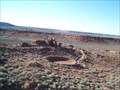
| Wupatki National Monument - Wupatki Pueblo in National Parks of the World The Wupatki Pueblo Ruin in the Wupatki National Monument has a number of rooms, an outdoor meeting area, and an arena. posted by: TerryDad2 location: Arizona date approved: 08/24/2006 last visited: 09/11/2019 |
 view gallery view gallerySE30.4 km |  Wupatki Pueblo Blowhole Wupatki Pueblo Blowhole
in Places of Geologic Significance This location is behind the Wupatki National Monument Visitor Center. A paved trail leads through the Wupatki Pueblo and down to the blowhole. Wheelchair accessable, but there are some relatively steep sections. posted by: TerryDad2 location: Arizona date approved: 01/31/2007 last visited: 02/19/2022 |
 view gallery view gallerySE30.4 km | Wupatki Pueblo in New World Ancient Evidence The Wupatki Pueblo Ruin in the Wupatki National Monument has a number of rooms, an outdoor meeting area, and an arena. posted by: TerryDad2 location: Arizona date approved: 07/26/2006 last visited: 02/19/2022 |
|