 view gallery view gallery W13 km W13 km
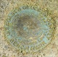
|   USGS TT 3 TX 1931 USGS TT 3 TX 1931
in U.S. Benchmarks A USGS Benchmark that is not in the database of Geocaching.com.It is at the location given for TT 1 by NGS on the Sand Gap, Arkansas Topo Map. NGS has No Descriptive Text Available for TT1. posted by:  Cardinal Cardinal location: Arkansas date approved: 01/18/2008 last visited: 10/24/2009 |
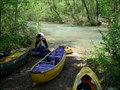
 view gallery view gallery NW15 km NW15 km
|  Upper Richland Creek Upper Richland Creek
in Canoe/Kayak Trips Seasonal Class III-IV run. posted by:  ar_kayaker ar_kayaker location: Arkansas date approved: 04/25/2007 last visited: never |
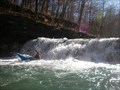
 view gallery view gallery N16.3 km N16.3 km
| Lower Richland Creek in Canoe/Kayak Trips A seasonal scenic class II-III+ whitewater run. Rain event dependent. posted by: ar_kayaker location: Arkansas date approved: 04/25/2007 last visited: never |
 view gallery view gallery SE22.5 km SE22.5 km
| South Fork of the Little Red River - Slick Rock in Canoe/Kayak Trips A scenic class II(III) trip through the Gulf Mountain Wildlife Managment Area. posted by: ar_kayaker location: Arkansas date approved: 05/02/2007 last visited: never |
 view gallery view galleryNW28.6 km |  Cowell Cemetery - Cowell, Arkansas Cowell Cemetery - Cowell, Arkansas
in Worldwide Cemeteries This small country cemetery is a mile south of the ghost town of Cowell, Arkansas. posted by: The Snowdog location: Arkansas date approved: 11/13/2020 last visited: never |
 view gallery view galleryW30.3 km | USFS Benchmark T12/ 1/4 S 30 29 /R 21 Haw Creek Falls Natural Area, Arkansas, U.S.A. in U.S. Benchmarks USDA benchmark in Haw Creek Falls, Arkansas posted by: Hummingbird & Blue Jay location: Arkansas date approved: 08/08/2014 last visited: never |
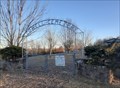
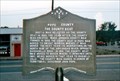 view gallery view gallery SW32.8 km SW32.8 km
|  Pope County The County Seat Pope County The County Seat
in Arkansas Historical Markers Located in small city park in downtown Dover. posted by: Markerman62 location: Arkansas date approved: 04/08/2015 last visited: 12/03/2016 |
 view gallery view gallery E36.9 km E36.9 km
|  ANTIQUE WAREHOUSE - Neon ANTIQUE WAREHOUSE - Neon
in Neon Signs Antique Warehouse North of Clinton Arkansas posted by: GEO*Trailblazer 1 location: Arkansas date approved: 11/18/2007 last visited: 04/05/2010 |
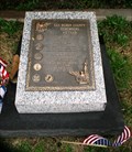
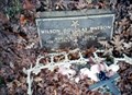
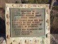 view gallery view galleryNW37.8 km |  Arkansas Farmers Union - Parthenon, AR Arkansas Farmers Union - Parthenon, AR
in Citizen Memorials This plaque, set in honor of those who made this area possible, overlooks a beautiful Arkansas valley - near Parthenon, Arkansas posted by: The Snowdog location: Arkansas date approved: 11/14/2020 last visited: never |
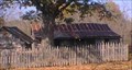 view gallery view galleryN38.6 km |  Collier Homestead @ Buffalo River NP Collier Homestead @ Buffalo River NP
in Homesteads Just a short easy walk of a couple minutes from the parking area...Can probably get a wheelchair to this location in dry weather (Dirt Trail) Visit this rustic home of the Collier Family if you get the chance posted by: CHI-TOWN ROMEO location: Arkansas date approved: 12/19/2008 last visited: 12/23/2008 |
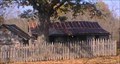 view gallery view galleryN38.6 km |  Collier Homestead Trail Collier Homestead Trail
in Hiking and walking trailheads Very nice trail located in Buffalo River national Park...The Trail head starts right in the parking area...I would consider part of the trail handicap accesible if the ground is dry. posted by: CHI-TOWN ROMEO location: Arkansas date approved: 12/22/2008 last visited: 12/23/2008 |
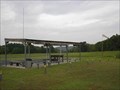
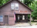 view gallery view galleryN39.9 km |  Ranger Station-Pruitt Information Station-Buffalo National River Ranger Station-Pruitt Information Station-Buffalo National River
in Ranger Stations You can obtain the National Park Buffalo National River Cancellation Stamp at the Pruitt Information Center. posted by: Don.Morfe location: Arkansas date approved: 02/17/2022 last visited: 02/11/2022 |
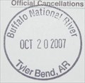 view gallery view galleryN39.9 km |  Buffalo National River - Tyler Bend Buffalo National River - Tyler Bend
in NPS Passport Cancellation Stations Buffalo National River - Tyler Bend posted by: ar_kayaker location: Arkansas date approved: 11/12/2007 last visited: 09/27/2018 |
 view gallery view galleryE42.3 km |  Vietnam War Memorial, Courthouse, Clinton, AR, USA Vietnam War Memorial, Courthouse, Clinton, AR, USA
in Vietnam War Memorials Vietnam War memorial located at the Van Buren County Courthouse, Elm and Griggs Streets, Clinton, Arkansas. posted by: HANSENNI location: Arkansas date approved: 03/12/2009 last visited: never |
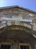 view gallery view gallerySW42.3 km |  Fair View School building, Russellville Arkansas Fair View School building, Russellville Arkansas
in WPA Projects A gorgeous Bungalow/craftsman style building build with WPA funding in 1938. Used as a school until 1960. Secondary uses for social events and community meetings. National Register of Historic places on 4 Feb 2000, number 00000030 PP0372. posted by: Seek2FindMe location: Arkansas date approved: 05/18/2019 last visited: 05/16/2019 |
 view gallery view gallerySW42.3 km |  Charles Jones Field Charles Jones Field
in Airports Russellville Remote Control Airplane Club posted by: NidoMio location: Arkansas date approved: 10/28/2005 last visited: never |
 view gallery view galleryE42.5 km |  Arkansas' Natrual Bridge Arkansas' Natrual Bridge
in Natural Arches Hidden away in the scenic beauty of the Ozarks, this 100-ft. sandstone formation was millions of years in the making. The stone archway was actually used as a bridge during pioneer days. Facilities include a log cabin museum and gift shop. Open mid-March through October. Located four miles north of Clinton off U.S. 65. posted by: maddlove location: Arkansas date approved: 07/30/2006 last visited: 11/03/2012 |
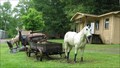 view gallery view galleryE42.6 km |  Buckskin and Buckboard at Clinton AR Buckskin and Buckboard at Clinton AR
in Fiberglass Horses This buckskin horse in front on a buckboard is part of a display that also includes a buffalo, elk and a mule, all advertising for a western furniture store. posted by: Queens Blessing location: Arkansas date approved: 06/11/2009 last visited: 09/02/2013 |
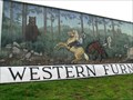
 view gallery view galleryE42.8 km |  Chuckwagon Fiasco - Clinton, Arkansas Chuckwagon Fiasco - Clinton, Arkansas
in Murals This pretty mural is on a barn near a western furniture store in rural Clinton, Arkansas. posted by: Queens Blessing location: Arkansas date approved: 06/06/2009 last visited: 06/13/2009 |
 view gallery view galleryE42.8 km | Bearly Surprised - Clinton, Arkansas in Murals This mural is on a barn at a Western Furniture Store in rural Clinton, Arkansas. It features a bear that surprised some riders. posted by: Queens Blessing location: Arkansas date approved: 06/06/2009 last visited: 06/13/2009 |
 view gallery view gallery S44.4 km S44.4 km
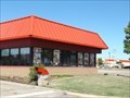
|  Hardee's - 3095 E. Main St - Russellville, AR Hardee's - 3095 E. Main St - Russellville, AR
in Carl's Jr./Hardee's Restaurants This is one of the two Hardee's locations in Russellville, AR. posted by: retail96 location: Arkansas date approved: 11/01/2018 last visited: never |
 view gallery view galleryS44.4 km |  Dollar Tree - E. Main St - Russellville, AR Dollar Tree - E. Main St - Russellville, AR
in Dollar Stores This is the Dollar Tree location in Russellville, AR. posted by: retail96 location: Arkansas date approved: 12/09/2018 last visited: never |
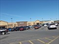 view gallery view galleryS44.6 km |  Walmart - Main St - Russellville, AR Walmart - Main St - Russellville, AR
in WAL*MART Stores This is one of the two Walmart locations in Russellville. AR. posted by: retail96 location: Arkansas date approved: 11/02/2018 last visited: 11/01/2018 |
 view gallery view galleryW45.2 km |  Wilson Douglas Watson-Ozone, AR Wilson Douglas Watson-Ozone, AR
in Medal Of Honor Resting Places World War II Medal of Honor Recipient for action at Iwo Jima, Volcano Islands on February 26-27, 1945. He is buried in Russell Cemetery, Ozone, AR. posted by: Don.Morfe location: Arkansas date approved: 12/23/2017 last visited: 12/18/2021 |
 view gallery view gallerySW45.5 km | K 25 (FG1178) - Russellville, Ar. in U.S. Benchmarks This benchmark is located on the former Russellville Train Station grounds - 320 West C Street in Russellville. posted by: iconions location: Arkansas date approved: 04/23/2014 last visited: never |
|