 view gallery view gallery S10.5 km S10.5 km
|   Mount Pleasant Cemetery Mount Pleasant Cemetery
in Worldwide Cemeteries Located of Hwy 111 posted by:  Better Half Better Half location: Tennessee date approved: 09/28/2007 last visited: 09/28/2007 |
 view gallery view galleryS10.6 km |  Mount Pleasent Congregational Methodist Church - TN Mount Pleasent Congregational Methodist Church - TN
in Country Churches Mount Pleasent Congregational Methodist Church in Sequatchie County Tennessee. posted by: BackBrakeBilly location: Tennessee date approved: 09/28/2007 last visited: 09/28/2007 |
 view gallery view gallery NE13.7 km NE13.7 km
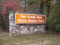
|  Fall Creek Falls State Park Fall Creek Falls State Park
in Wikipedia Entries Fall Creek Falls is a state park located in Middle Tennessee. posted by:  Titansfan Titansfan location: Tennessee date approved: 10/29/2007 last visited: 11/22/2012 |
 view gallery view galleryNE13.7 km |  Fall Creek Falls State Park - Tennessee Fall Creek Falls State Park - Tennessee
in State/Provincial Parks Fall Creek Falls State Park, located in Middle Tennessee. posted by: Titansfan location: Tennessee date approved: 11/03/2007 last visited: 11/22/2012 |
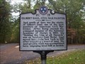 view gallery view galleryNE14.6 km |  Gilbert Gaul, Civil War Painter ~ 2C 15 Gilbert Gaul, Civil War Painter ~ 2C 15
in Tennessee Historical Markers Gilbert Gaul, a Civil War Painter posted by: Titansfan location: Tennessee date approved: 10/29/2007 last visited: 10/22/2014 |
 view gallery view galleryNE15 km |  Fall Creek Falls State Park Penny Smasher Fall Creek Falls State Park Penny Smasher
in Penny Smashers This four-design hand-cranked Penny Smasher is in the main lobby of the Fall Creek Falls State Park Inn & Conference Center located at 2009 Village Camp Road northwest of Pikeville, Tennessee. posted by: brwhiz location: Tennessee date approved: 06/01/2013 last visited: 08/26/2015 |
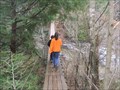
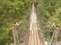 view gallery view galleryNE15.3 km |  Piney Falls Bridge Piney Falls Bridge
in Pedestrian Suspension Bridges This is a "swinging" bridge over Piney Creek. There are four bridges in this park I have photos of two. posted by: Laura.Beldavs location: Tennessee date approved: 04/06/2008 last visited: 08/19/2009 |
 view gallery view galleryNE15.4 km |  Piney Falls Piney Falls
in Waterfalls Piney Falls, a 95-foot (29 m) waterfall located along Piney Creek, a mile or so above its confluence with Cane Creek. Trails lead to the base of the falls and an overlook above the falls.-Wikipedia
I think this is the best Falls in the park. posted by: Laura.Beldavs location: Tennessee date approved: 04/06/2008 last visited: 04/14/2016 |
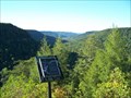
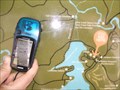 view gallery view galleryNE15.8 km |  Your Are Here- Fall Creek Falls State Park Your Are Here- Fall Creek Falls State Park
in 'You Are Here' Maps This is at the information and Camp Store area of Fall Creek Falls State Park Tennessee posted by: Laura.Beldavs location: Tennessee date approved: 03/31/2008 last visited: never |
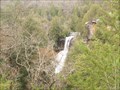
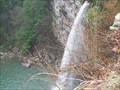
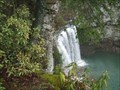
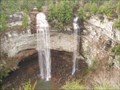 view gallery view galleryNE16.6 km | Fall Creek Falls in Waterfalls Fall Creek Falls, a 256-foot plunge waterfall located just west of the creek's confluence with Cane Creek. A short trail leads from the parking lot atop the plateau down to the base of the gorge, giving access to the waterfall's plungepool.-Wikipedia posted by: Laura.Beldavs location: Tennessee date approved: 03/31/2008 last visited: 06/22/2021 |
 view gallery view galleryNE16.6 km | Coon Creek Falls in Waterfalls Coon Creek Falls, a 250-foot (76 m) plunge waterfall that drops into the Fall Creek Gorge, nearly adjacent Fall Creek Falls. Its proximity to Fall Creek Falls renders it less conspicuous. It is on the Right in this Photo-Wikipedia posted by: Laura.Beldavs location: Tennessee date approved: 04/06/2008 last visited: 10/22/2014 |
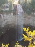 view gallery view galleryNE16.6 km |  HIGHEST waterfall east of the Rocky Mountains - Bledsoe County, TN HIGHEST waterfall east of the Rocky Mountains - Bledsoe County, TN
in Superlatives A historical sign near the falls overlook states that the Fall Creek Falls are 266 feet high posted by: Max and 99 location: Tennessee date approved: 12/04/2019 last visited: 06/22/2021 |
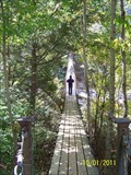 view gallery view galleryNE16.6 km | Cane Creek Suspension Bridge - Fall Creek Falls State Park, TN in Pedestrian Suspension Bridges Cane Creek Suspension Bridge - Fall Creek Falls State Park, TN posted by: hummerstation location: Tennessee date approved: 10/24/2011 last visited: never |
 view gallery view galleryNE16.6 km | Cane Creek Falls Swinging Bridge in Pedestrian Suspension Bridges Cane Creek Falls Swinging bridge is one of four swinging bridges in the Fall Creek Falls State Park. It spans the Cane Creek. posted by: Laura.Beldavs location: Tennessee date approved: 04/06/2008 last visited: never |
 view gallery view gallery SW16.7 km SW16.7 km
| Tarlton Cemetery in Worldwide Cemeteries Scruggs Memorial and Tarlton Cemetery
posted by: Better Half location: Tennessee date approved: 10/02/2007 last visited: 10/02/2007 |
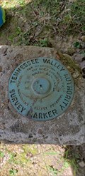 view gallery view galleryNE16.7 km |  TVA MLB234 Survey Marker - Fall Creek Falls State Park, TN TVA MLB234 Survey Marker - Fall Creek Falls State Park, TN
in U.S. Benchmarks Found near the visitor's center at Fall Creek Falls State Park posted by: HiddenCrazy location: Tennessee date approved: 04/26/2021 last visited: 07/17/2020 |
 view gallery view gallerySW16.7 km | Tarlton Community Church ~ Grundy County Tennessee. in Country Churches Tarlton Community Church in Grundy County Tennessee. posted by: BackBrakeBilly location: Tennessee date approved: 10/03/2007 last visited: 09/06/2007 |
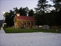 view gallery view gallerySW16.7 km |  Tarlton Community Church and Cemetery - Grundy County Tennessee. Tarlton Community Church and Cemetery - Grundy County Tennessee.
in Churchyard Cemeteries Tarlton Community Church and Cemetery in Grundy County Tennessee. posted by: BackBrakeBilly location: Tennessee date approved: 10/03/2007 last visited: 09/06/2007 |
 view gallery view galleryNE16.7 km | Cane Creek Falls in Waterfalls Cane Creek Falls, an 85-foot (26 m) plunge waterfall located along Cane Creek, above the creek's confluence with Rockhouse Creek and Fall Creek. -Wikipedia posted by: Laura.Beldavs location: Tennessee date approved: 03/31/2008 last visited: 10/01/2011 |
 view gallery view galleryNE16.7 km | Cane Creek Cascades in Waterfalls Cane Creek Cascades, a 45-foot (14 m) cascade located along Cane Creek, just above Cane Creek Falls. -Wikipedia posted by: Laura.Beldavs location: Tennessee date approved: 03/31/2008 last visited: 10/01/2011 |
 view gallery view galleryNE16.9 km |  Millikan’s Overlook and Buzzard’s Roost - Fall Creek Falls State Park, TN Millikan’s Overlook and Buzzard’s Roost - Fall Creek Falls State Park, TN
in Scenic Roadside Look-Outs Millikan’s Overlook and Buzzard’s Roost, Fall Creek Falls State Park, TN posted by: hummerstation location: Tennessee date approved: 12/14/2011 last visited: 04/14/2016 |
 view gallery view gallerySW18.5 km | BEERSHEBA INN ~ 2E 25 in Tennessee Historical Markers N35 27.886 W085 39.186 posted by: Better Half location: Tennessee date approved: 10/02/2007 last visited: 09/06/2007 |
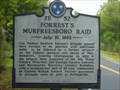 view gallery view gallerySW18.5 km | Forrest's Murfreesboro Raid - July, 10, 1862 - 2E 52 in Tennessee Historical Markers A marker on the side of the road not far from the Savage Gulf Natural Area. posted by: ggmorton location: Tennessee date approved: 10/19/2007 last visited: 09/30/2007 |
 view gallery view gallerySW18.7 km | Mary Noalilles Murfree ~ 2E 42 in Tennessee Historical Markers Mary Noalilles Murfree ~ 2E 42 posted by: Better Half location: Tennessee date approved: 10/02/2007 last visited: 09/30/2007 |
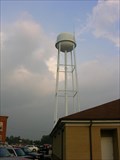 view gallery view gallery N19.2 km N19.2 km
|  Spencer TN Water Tower ~ Spencer Tennessee Spencer TN Water Tower ~ Spencer Tennessee
in Water Towers Spencer TN Water Tower in Spencer Tennessee. posted by: BackBrakeBilly location: Tennessee date approved: 10/05/2007 last visited: 01/19/2008 |
|