 view gallery view gallery NE1.3 km NE1.3 km
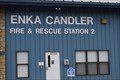
|   Enka Candler Fire & Rescue Station 2 Enka Candler Fire & Rescue Station 2
in Firehouses The beginnings of this fine fire department were rooted in a company doing right by its workers. The current department continues that same spirit with its dedication to service to their neighbors, family, friends, and guest of the area. posted by:  NCDaywalker NCDaywalker location: North Carolina date approved: 05/12/2016 last visited: 05/13/2016 |
 view gallery view gallery W5.1 km W5.1 km
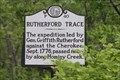
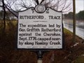
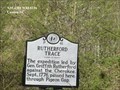
|  Rutherford Trace-P 40 Rutherford Trace-P 40
in North Carolina Historical Markers Located on US 19 just east of Canton posted by: Markerman62 location: North Carolina date approved: 05/25/2016 last visited: 05/21/2016 |
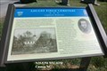 view gallery view galleryW7.2 km |  Locust Field Cemetery-Confederate Rendezvous - Canton NC Locust Field Cemetery-Confederate Rendezvous - Canton NC
in Civil War Discovery Trail Sites The church and cemetery were again used as a Confederate encampment during the winter of 1864-1865, when Col. James Robert Love and six companies of Thomas’s Legion camped at Locust Old Fields Church. posted by:  Don.Morfe Don.Morfe location: North Carolina date approved: 04/17/2020 last visited: 08/30/2022 |
 view gallery view galleryW7.2 km | Locust Field Cemetery-Confederate Rendezvous - Canton NC in U.S. Civil War Sites During the Civil War, Old Fields Baptist Church was a muster site for the local 112th Beaverdam Militia Regiment, according to local tradition. The church and cemetery were again used as a Confederate encampment during the winter of 1864-1865. posted by: Don.Morfe location: North Carolina date approved: 04/12/2023 last visited: 04/12/2023 |
 view gallery view galleryW7.2 km |  Locust Field Cemetery - Canton NC Locust Field Cemetery - Canton NC
in Worldwide Cemeteries Today, as one of Haywood County’s oldest cemeteries, Locust Field Cemetery serves as a reminder of the county’s role in the Civil War. Dozens of Confederate veterans are interred here. posted by: Don.Morfe location: North Carolina date approved: 04/11/2023 last visited: 04/12/2023 |
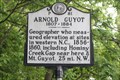 view gallery view galleryW7.2 km | Arnold Guyot 1807~1884-P 81 in North Carolina Historical Markers Located on US 19 at Hampton Heights Rd posted by: Markerman62 location: North Carolina date approved: 05/25/2016 last visited: 06/16/2018 |
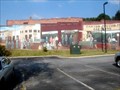
 view gallery view galleryW7.4 km |  Downtown Canton - Canton, NC Downtown Canton - Canton, NC
in Murals A very long painting of downtown Canton, NC. posted by: papermanone & catlover location: North Carolina date approved: 06/07/2008 last visited: 06/16/2018 |
 view gallery view galleryW7.6 km | Morning Star Church - P 19 in North Carolina Historical Markers A marker on the corner of Park St and Academy St in Canton, NC. posted by: ggmorton location: North Carolina date approved: 05/27/2009 last visited: 05/26/2009 |
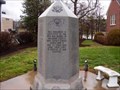 view gallery view galleryW7.7 km |  Haywood County World War II Monument --- Canton in Haywood County, North Carolina Haywood County World War II Monument --- Canton in Haywood County, North Carolina
in World War II Memorials / Monuments Marker is in Canton, North Carolina, in Haywood County. Marker is on Park Street (North Carolina Route 19/23) posted by: Countrydragon location: North Carolina date approved: 01/31/2010 last visited: 06/16/2018 |
 view gallery view galleryW7.7 km | Canton Auction Co. - Canton, NC in Murals The Canton Auction Co. mural is located in downtown Canton, NC. posted by: papermanone & catlover location: North Carolina date approved: 06/07/2008 last visited: 06/16/2018 |
 view gallery view gallery E7.9 km E7.9 km
| Rutherford Trace - P-39 in North Carolina Historical Markers Marker is in Hominy, North Carolina, in Buncombe County. Marker is on Smokey Park Highway (U.S. 19/23)Marker is at or near this postal address: 1189 Smokey Park Hwy, Candler NC 28715, United States of America.
posted by: Countrydragon location: North Carolina date approved: 12/30/2009 last visited: 09/13/2001 |
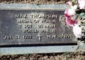 view gallery view galleryE8.4 km |  Max Thompson-Candler, NC Max Thompson-Candler, NC
in Medal Of Honor Resting Places World War II Medal of Honor Recipient for action near Haaren, Germany on October 18, 1944. He is buried in Forest Lawn Memorial Park, Candler, NC in Section 9, Lot 68. posted by: Don.Morfe location: North Carolina date approved: 12/19/2017 last visited: 12/18/2021 |
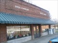
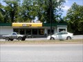 view gallery view galleryW8.7 km |  Subway - Canton, NC Subway - Canton, NC
in Subway Restaurants The Canton Subway. posted by: papermanone & catlover location: North Carolina date approved: 06/22/2007 last visited: 06/22/2007 |
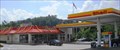 view gallery view galleryW8.9 km |  McDonald's WIFi - I-40 Exit 31 - Canton, NC McDonald's WIFi - I-40 Exit 31 - Canton, NC
in Wi-Fi Hotspots Checking for the next waymark location at a Shell/McD's gas & go combo. posted by: vhasler location: North Carolina date approved: 07/22/2013 last visited: never |
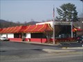
 view gallery view galleryW8.9 km |  McDonald's - I-40 Exit 31 - Canton, NC McDonald's - I-40 Exit 31 - Canton, NC
in McDonald's Restaurants Shell/McD's combo for gas and go... posted by: vhasler location: North Carolina date approved: 07/23/2013 last visited: never |
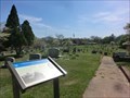
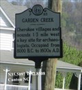
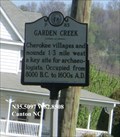 view gallery view galleryW9 km | Garden Creek (P-83) in North Carolina Historical Markers Cherokee villages and mounds 1/3 mile west a key site for archaeologists. Occupied from 8000 B.C. to 1600s A.D. posted by: Don.Morfe location: North Carolina date approved: 03/19/2020 last visited: 08/30/2022 |
 view gallery view galleryW9 km |  Garden Creek - Canton NC Garden Creek - Canton NC
in Civil Rights Memorials Garden Creek-Cherokee villages and mounds 1/3 mile west a key site for archaeologists. posted by: Don.Morfe location: North Carolina date approved: 03/19/2023 last visited: 03/19/2023 |
 view gallery view galleryE9.3 km |  Enka - Candler Public Library -- Enka, NC Enka - Candler Public Library -- Enka, NC
in Libraries The Enka - Candler Public Library posted by: papermanone & catlover location: North Carolina date approved: 12/21/2006 last visited: never |
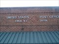 view gallery view galleryE9.3 km |  Enka, NC 28728 Enka, NC 28728
in U.S. Post Offices The Enka, NC Post Office. posted by: papermanone & catlover location: North Carolina date approved: 12/21/2006 last visited: never |
 view gallery view galleryE10.6 km | McDonald's - Smoky Park Highway, Asheville, NC in McDonald's Restaurants A busy McDonalds on I-40. posted by: papermanone & catlover location: North Carolina date approved: 12/20/2006 last visited: 06/18/2007 |
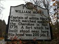 view gallery view galleryE11.1 km | William Moore | P-54 in North Carolina Historical Markers Located on SR 3412 (Sand Hill Road) east of Enka posted by: 3newsomes location: North Carolina date approved: 11/27/2012 last visited: 11/23/2012 |
 view gallery view galleryE11.1 km |  Crowell Rd Cracker Barrel - Asheville, NC Crowell Rd Cracker Barrel - Asheville, NC
in Cracker Barrel Restaurants Off I40 just west of Asheville. posted by: ChapterhouseInc location: North Carolina date approved: 07/16/2010 last visited: 07/14/2018 |
 view gallery view gallery SW11.9 km SW11.9 km
| Rutherford Trace (P-41) in North Carolina Historical Markers The expedition led by Gen. Griffith Rutherford against the Cherokee, Sept. 1776, passed here, through Pigeon Gap. posted by: Don.Morfe location: North Carolina date approved: 04/02/2020 last visited: 10/23/2021 |
 view gallery view gallery S12.2 km S12.2 km
|  WLOS TV 13 Transmission Tower - Waynesville, NC, UA WLOS TV 13 Transmission Tower - Waynesville, NC, UA
in Radio and Television Transmitter Towers This is located at the peak on Mt Pisgah just off the Blue Ridge Parkway. It's a 1.5 mile hike to the tower from the trailhead at the parking area. Elevation at the waymark is 5718 feet. Go up to the tower and you're 3 feet higher up. :-) posted by: Col. Bucky location: North Carolina date approved: 06/17/2021 last visited: never |
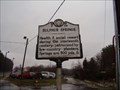 view gallery view galleryE12.9 km | Sulphur Springs - P-53 in North Carolina Historical Markers Marker is in Asheville, North Carolina, in Buncombe County. Marker is at the intersection of Patton Avenue (U.S. 19) and Old Haywood Road (North Carolina Route 1404) on Patton Avenue posted by: Countrydragon location: North Carolina date approved: 12/30/2009 last visited: 05/20/2016 |
|