 view gallery view gallery NE4.7 km NE4.7 km
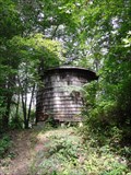
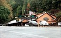
|   Old Woodie H2O Tower, Fontana Village, North Carolina Old Woodie H2O Tower, Fontana Village, North Carolina
in Water Towers An old wodden water tower still in use near the Fontana TVA Dam. posted by:  PersonsMD PersonsMD location: North Carolina date approved: 09/15/2009 last visited: 09/13/2009 |
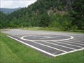 view gallery view galleryNE5 km |  TVA Fontana Dam Landing Pad, Fontana Villiage, North Carolina TVA Fontana Dam Landing Pad, Fontana Villiage, North Carolina
in Helicopter Landing Pads A landing pad located at the outflow of the Fontana Dam in North Carolina. Located in the Great Smokey Mountain National Park on the Little Tennessee River. posted by: PersonsMD location: North Carolina date approved: 09/14/2009 last visited: 09/13/2009 |
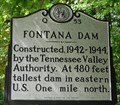 view gallery view galleryNE5.5 km |  Fontana Dam ~ Q 53 Fontana Dam ~ Q 53
in North Carolina Historical Markers A marker noting the construction of the Fontana Dam, located on highway 28 near Fontana Village, North Carolina. posted by: PersonsMD location: North Carolina date approved: 09/19/2009 last visited: 02/04/2017 |
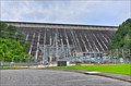 view gallery view galleryNE5.8 km |  Fontana Dam - Robbinsville NC Fontana Dam - Robbinsville NC
in Hydroelectric Power Stations Fontana Dam is a hydroelectric dam on the Little Tennessee River in Swain and Graham counties, North Carolina, United States. posted by: nomadwillie location: North Carolina date approved: 11/03/2013 last visited: 06/24/2022 |
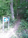 view gallery view galleryNE6 km |  AT Trail Head at Fontana Crossing, North Carolina AT Trail Head at Fontana Crossing, North Carolina
in Appalachian Trail An AT trail head at Fontana Crossing near Fontana Village, North Carolina and the Fontana Dam. posted by: PersonsMD location: North Carolina date approved: 09/18/2009 last visited: 08/21/2010 |
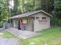 view gallery view galleryNE6 km | Fontana Crossing, Fontana Dam, North Carolina in Appalachian Trail Fontana Crossing is located on the Appalachian Trail and is near Fontana Dam and the town of Fontana Village Resort. Yes a bathroom, coke machine and telephone! posted by: PersonsMD location: North Carolina date approved: 09/18/2009 last visited: 09/13/2009 |
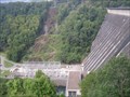 view gallery view galleryNE6.1 km |  Fontana Dam Fontana Dam
in Wikipedia Entries The Highest dam in the TVA system,and highest concrete dam East of the Rocky Mountains. Completed in 1944 it is 480 feet high and 2,385 feet across. Creates Fontana Lake with 10,230 acres of water surface.
posted by: PersonsMD location: North Carolina date approved: 09/16/2009 last visited: 02/04/2017 |
 view gallery view galleryNE6.1 km |  Fontana Dam, Fontana Village, North Carolina Fontana Dam, Fontana Village, North Carolina
in Water Dams The Highest dam in the TVA system,and highest concrete dam East of the Rocky Mountains. Completed in 1944 it is 480 feet high and 2,385 feet across. Creates Fontana Lake with 10,230 acres of water surface. posted by: PersonsMD location: North Carolina date approved: 09/16/2009 last visited: 02/04/2017 |
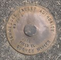
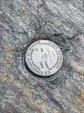
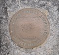 view gallery view galleryNE6.3 km |  TVA Survey Marker, 32-2, Fontana Dam, North Carolina TVA Survey Marker, 32-2, Fontana Dam, North Carolina
in U.S. Benchmarks Located on the roadbed of the Tennessee Valley Authority Fontana Dam in North Carolina. posted by: PersonsMD location: North Carolina date approved: 09/17/2009 last visited: 07/09/2011 |
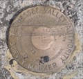
 view gallery view galleryNE6.3 km | TVA Survey Marker 33-2R, Fontana Dam, North Carolina in U.S. Benchmarks A Tennessee Valley Authority Survey Mark located in the roadbed that crosses the crest of the Fontana Dam in North Carolina. posted by: PersonsMD location: North Carolina date approved: 09/17/2009 last visited: 07/09/2011 |
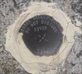
 view gallery view galleryNE6.3 km | TVA Survey Marker 38-4, Fontana Dam, North Carolina in U.S. Benchmarks A Tennessee Valley Authority Survey Marker located between the two dam spillway over flow funnels for Fontana dam in North Carolina. posted by: PersonsMD location: North Carolina date approved: 09/20/2009 last visited: 08/13/2009 |
 view gallery view galleryNE6.3 km | TVA Survey Marker 34-1, Fontana Dam, North Carolina in U.S. Benchmarks A Tennessee Valley Authority Survey Marker located on the road over the Fontana Dam in North Carolina posted by: PersonsMD location: North Carolina date approved: 09/17/2009 last visited: 08/21/2010 |
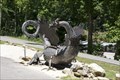
 view gallery view gallery NW8.7 km NW8.7 km
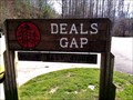
|  Deals Gap, North Carolina (Dragon's Tail) Deals Gap, North Carolina (Dragon's Tail)
in Elevation Signs Deals Gap, North Carolina Elevation 1756 Ft posted by: Rat Rat location: North Carolina date approved: 04/12/2011 last visited: 03/27/2024 |
 view gallery view galleryNW8.7 km | Deals Gap, North Carolina in Wikipedia Entries The Dragon two-lane stretch of U.S. 129 to the north. Its 318 curves in 11 miles earned it the name Tail of the Dragon. posted by: YoSam. location: North Carolina date approved: 02/11/2019 last visited: never |
 view gallery view galleryNW8.7 km |  The Dragon: Super-twisty N.C. Road is the Ultimate Fall Ride The Dragon: Super-twisty N.C. Road is the Ultimate Fall Ride
in News Article Locations It’s the two-lane stretch of U.S. 129 to the north. Its 318 curves in 11 miles earned it the name Tail of the Dragon. posted by: YoSam. location: North Carolina date approved: 02/10/2019 last visited: 03/27/2024 |
 view gallery view galleryNW8.7 km |  Tail of the Dragon - Deals Gap, North Carolina Tail of the Dragon - Deals Gap, North Carolina
in Roadside Attractions It’s the two-lane stretch of U.S. 129 to the north. Its 318 curves in 11 miles earned it the name Tail of the Dragon. posted by: YoSam. location: North Carolina date approved: 02/10/2019 last visited: 04/10/2014 |
 view gallery view galleryNW9.3 km |  Tennessee & North Carolina State Line Tennessee & North Carolina State Line
in Border Crossings Border crossing for Tennessee and North Carolina on Highway 129. This crossing is located in the Great Smokey Mountain National Park posted by: PersonsMD location: Tennessee date approved: 09/16/2009 last visited: 03/18/2013 |
 view gallery view galleryNW9.5 km |  Tail of the Dragon N35° 28.436 W83° 55.262 Tail of the Dragon N35° 28.436 W83° 55.262
in Web Cameras Webcam along Highway 129 posted by: Sakidoo location: Tennessee date approved: 03/29/2018 last visited: never |
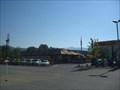 view gallery view gallery SE10.5 km SE10.5 km
|  Robbinsville McDonalds Robbinsville McDonalds
in McDonald's Restaurants Mc Donalds in Robbinsville NC. posted by:  fatcat161 fatcat161 location: North Carolina date approved: 10/11/2008 last visited: 07/20/2008 |
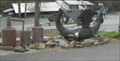
 view gallery view gallery S10.6 km S10.6 km
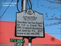
|  Junaluska - Robbinsville NC Junaluska - Robbinsville NC
in Civil Rights Memorials Junaluska ca. 1779 - 1858 Cherokee warrior, fought for U.S. in Creek War, 1814. Granted citizenship and land by N.C., 1847. Grave is one mile S.W. posted by: Don.Morfe location: North Carolina date approved: 03/18/2023 last visited: 03/17/2023 |
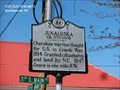 view gallery view galleryS10.6 km | Junaluska in North Carolina Historical Markers Junaluska ca. 1779 - 1858 Cherokee warrior, fought for U.S. in Creek War, 1814. Granted citizenship and land by N.C., 1847. Grave is one mile S.W. posted by: Don.Morfe location: North Carolina date approved: 04/02/2020 last visited: 10/23/2021 |
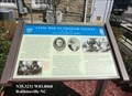 view gallery view galleryS10.6 km |  Civil War in Graham County Union and Confederate Raiders - Robbinsville NC Civil War in Graham County Union and Confederate Raiders - Robbinsville NC
in Civil War Discovery Trail Sites During the Civil War, Graham Country (the part of Cherokee County) offered scant support to the secessionist cause, although both ardent Confederates and staunch Unionists lived here. posted by: Don.Morfe location: North Carolina date approved: 05/02/2020 last visited: 10/08/2021 |
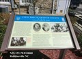 view gallery view galleryS10.6 km | Civil War in Graham County - Robbinsville NC in U.S. Civil War Sites During the Civil War, Graham Country (the part of Cherokee County) offered scant support to the secessionist cause, although both ardent Confederates and staunch Unionists lived here. The region was not financially dependent on slavery. posted by: Don.Morfe location: North Carolina date approved: 04/25/2023 last visited: 04/25/2023 |
 view gallery view galleryNW10.8 km | ET 50 WCE (FB2377) Tapoco - Blount County, TN in U.S. Benchmarks Very easy to find survey disk at a small pull-off on The Dragon. posted by: Team Geologynut location: Tennessee date approved: 02/23/2023 last visited: never |
 view gallery view galleryS10.9 km |  Junaluska and Nicie Gravesite - Robbinsville, NC Junaluska and Nicie Gravesite - Robbinsville, NC
in Trail of Tears Junaluska Museum is located on Junaluska Rd in Robbinsville, NC posted by: nomadwillie location: North Carolina date approved: 05/17/2011 last visited: 05/22/2008 |
|