 view gallery view gallery NW7.7 km NW7.7 km
|   Fontana Crossing, Fontana Dam, North Carolina Fontana Crossing, Fontana Dam, North Carolina
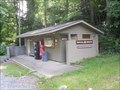
in Appalachian Trail Fontana Crossing is located on the Appalachian Trail and is near Fontana Dam and the town of Fontana Village Resort. Yes a bathroom, coke machine and telephone! posted by:  PersonsMD PersonsMD location: North Carolina date approved: 09/18/2009 last visited: 09/13/2009 |
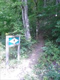 view gallery view galleryNW7.9 km | AT Trail Head at Fontana Crossing, North Carolina in Appalachian Trail An AT trail head at Fontana Crossing near Fontana Village, North Carolina and the Fontana Dam. posted by: PersonsMD location: North Carolina date approved: 09/18/2009 last visited: 08/21/2010 |
 view gallery view galleryNW8.2 km |  Fontana Dam ~ Q 53 Fontana Dam ~ Q 53
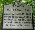
in North Carolina Historical Markers A marker noting the construction of the Fontana Dam, located on highway 28 near Fontana Village, North Carolina. posted by: PersonsMD location: North Carolina date approved: 09/19/2009 last visited: 02/04/2017 |
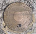
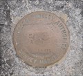
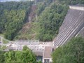
 view gallery view galleryNW9 km |  TVA Survey Marker 38-4, Fontana Dam, North Carolina TVA Survey Marker 38-4, Fontana Dam, North Carolina
in U.S. Benchmarks A Tennessee Valley Authority Survey Marker located between the two dam spillway over flow funnels for Fontana dam in North Carolina. posted by: PersonsMD location: North Carolina date approved: 09/20/2009 last visited: 08/13/2009 |
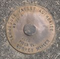
 view gallery view galleryNW9 km | TVA Survey Marker 34-1, Fontana Dam, North Carolina in U.S. Benchmarks A Tennessee Valley Authority Survey Marker located on the road over the Fontana Dam in North Carolina posted by: PersonsMD location: North Carolina date approved: 09/17/2009 last visited: 08/21/2010 |
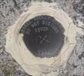 view gallery view galleryNW9 km | TVA Survey Marker 33-2R, Fontana Dam, North Carolina in U.S. Benchmarks A Tennessee Valley Authority Survey Mark located in the roadbed that crosses the crest of the Fontana Dam in North Carolina. posted by: PersonsMD location: North Carolina date approved: 09/17/2009 last visited: 07/09/2011 |
 view gallery view galleryNW9 km | TVA Survey Marker, 32-2, Fontana Dam, North Carolina in U.S. Benchmarks Located on the roadbed of the Tennessee Valley Authority Fontana Dam in North Carolina. posted by: PersonsMD location: North Carolina date approved: 09/17/2009 last visited: 07/09/2011 |
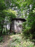 view gallery view galleryNW9 km |  Old Woodie H2O Tower, Fontana Village, North Carolina Old Woodie H2O Tower, Fontana Village, North Carolina
in Water Towers An old wodden water tower still in use near the Fontana TVA Dam. posted by: PersonsMD location: North Carolina date approved: 09/15/2009 last visited: 09/13/2009 |
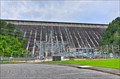 view gallery view galleryNW9.2 km |  Fontana Dam - Robbinsville NC Fontana Dam - Robbinsville NC
in Hydroelectric Power Stations Fontana Dam is a hydroelectric dam on the Little Tennessee River in Swain and Graham counties, North Carolina, United States. posted by: nomadwillie location: North Carolina date approved: 11/03/2013 last visited: 06/24/2022 |
 view gallery view galleryNW9.2 km |  Fontana Dam Fontana Dam
in Wikipedia Entries The Highest dam in the TVA system,and highest concrete dam East of the Rocky Mountains. Completed in 1944 it is 480 feet high and 2,385 feet across. Creates Fontana Lake with 10,230 acres of water surface.
posted by: PersonsMD location: North Carolina date approved: 09/16/2009 last visited: 02/04/2017 |
 view gallery view galleryNW9.2 km |  Fontana Dam, Fontana Village, North Carolina Fontana Dam, Fontana Village, North Carolina
in Water Dams The Highest dam in the TVA system,and highest concrete dam East of the Rocky Mountains. Completed in 1944 it is 480 feet high and 2,385 feet across. Creates Fontana Lake with 10,230 acres of water surface. posted by: PersonsMD location: North Carolina date approved: 09/16/2009 last visited: 02/04/2017 |
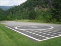 view gallery view galleryNW9.8 km |  TVA Fontana Dam Landing Pad, Fontana Villiage, North Carolina TVA Fontana Dam Landing Pad, Fontana Villiage, North Carolina
in Helicopter Landing Pads A landing pad located at the outflow of the Fontana Dam in North Carolina. Located in the Great Smokey Mountain National Park on the Little Tennessee River. posted by: PersonsMD location: North Carolina date approved: 09/14/2009 last visited: 09/13/2009 |
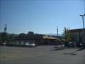 view gallery view gallery SW11.9 km SW11.9 km
|  Robbinsville McDonalds Robbinsville McDonalds
in McDonald's Restaurants Mc Donalds in Robbinsville NC. posted by:  fatcat161 fatcat161 location: North Carolina date approved: 10/11/2008 last visited: 07/20/2008 |
 view gallery view gallery E12.1 km E12.1 km
|  Tsali Recreational Area Tsali Recreational Area
in Mountain Bike Trailheads Probably the most popular features of Tsali Recreation Area are the 39 miles of trails suited for mountain bikers and horse-back riders, as well as hikers. The 4-loop system offers a variety of landscapes. You can climb 1-foot wide rugged paths or travel flat, well-beaten roads meander through mixed pine and hardwoods on a peninsula stretching into Fontana Lake.
posted by: Ditchdoc531 location: North Carolina date approved: 09/08/2005 last visited: never |
 view gallery view gallerySW12.4 km |  Civil War in Graham County Union and Confederate Raiders - Robbinsville NC Civil War in Graham County Union and Confederate Raiders - Robbinsville NC
in Civil War Discovery Trail Sites During the Civil War, Graham Country (the part of Cherokee County) offered scant support to the secessionist cause, although both ardent Confederates and staunch Unionists lived here. posted by: Don.Morfe location: North Carolina date approved: 05/02/2020 last visited: 10/08/2021 |
 view gallery view gallerySW12.4 km | Civil War in Graham County - Robbinsville NC in U.S. Civil War Sites During the Civil War, Graham Country (the part of Cherokee County) offered scant support to the secessionist cause, although both ardent Confederates and staunch Unionists lived here. The region was not financially dependent on slavery. posted by: Don.Morfe location: North Carolina date approved: 04/25/2023 last visited: 04/25/2023 |
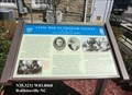
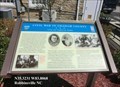
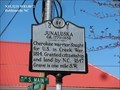
 view gallery view gallerySW12.4 km | Junaluska in North Carolina Historical Markers Junaluska ca. 1779 - 1858 Cherokee warrior, fought for U.S. in Creek War, 1814. Granted citizenship and land by N.C., 1847. Grave is one mile S.W. posted by: Don.Morfe location: North Carolina date approved: 04/02/2020 last visited: 10/23/2021 |
 view gallery view gallerySW12.4 km |  Junaluska - Robbinsville NC Junaluska - Robbinsville NC
in Civil Rights Memorials Junaluska ca. 1779 - 1858 Cherokee warrior, fought for U.S. in Creek War, 1814. Granted citizenship and land by N.C., 1847. Grave is one mile S.W. posted by: Don.Morfe location: North Carolina date approved: 03/18/2023 last visited: 03/17/2023 |
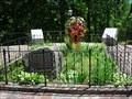 view gallery view gallerySW12.7 km |  Junaluska and Nicie Gravesite - Robbinsville, NC Junaluska and Nicie Gravesite - Robbinsville, NC
in Trail of Tears Junaluska Museum is located on Junaluska Rd in Robbinsville, NC posted by: nomadwillie location: North Carolina date approved: 05/17/2011 last visited: 05/22/2008 |
 view gallery view gallery SE14.3 km SE14.3 km
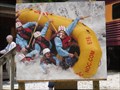
|  "Raftie, Raftie," Wesser, North Carolina "Raftie, Raftie," Wesser, North Carolina
in Photo Cutouts A fun lifelike cut out at a water rafting pull out on the Great Smokey Mountain Rail Road. posted by: PersonsMD location: North Carolina date approved: 09/14/2009 last visited: 09/12/2009 |
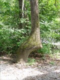 view gallery view gallerySE14.3 km |  Cherokee Trail Tree, Wesner, North Carolina Cherokee Trail Tree, Wesner, North Carolina
in Native American Trail Trees Trail tree pointing directly at the confluence of the Nantahala River and Wesser Creek. posted by: PersonsMD location: North Carolina date approved: 09/13/2009 last visited: 08/22/2012 |
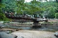 view gallery view gallerySE14.3 km |  Founder's Bridge, Wesser NC Founder's Bridge, Wesser NC
in Truss Bridges Located directly off of highway 74 posted by: CoinsAndPins location: North Carolina date approved: 08/29/2007 last visited: 08/13/2020 |
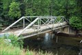 view gallery view gallerySE14.3 km |  NC-1180 Bridge NC-1180 Bridge
in Orphaned Bridges Located right off of highway 74 posted by: CoinsAndPins location: North Carolina date approved: 08/26/2007 last visited: 06/22/2009 |
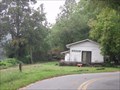 view gallery view galleryE14.6 km |  Southern Railway Almond Station, Almond, North Carolina Southern Railway Almond Station, Almond, North Carolina
in Train Stations/Depots A wonderful Southern Railway train station from the past that is now a private residence. Located in Almond North Carolina posted by: PersonsMD location: North Carolina date approved: 09/17/2009 last visited: 09/11/2009 |
 view gallery view gallery S15 km S15 km
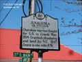
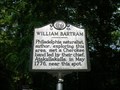
| WILLIAM BARTRAM ~ Q 44 in North Carolina Historical Markers This marker is located on Hwy. 74 at the Patton's Run pull off in the Nantahala Gorge. posted by: BackBrakeBilly location: North Carolina date approved: 09/11/2007 last visited: 08/30/2022 |
|