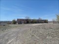
 view gallery view gallery N10.8 km N10.8 km
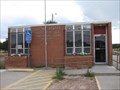
|   Continental Divide, NM 87312 Continental Divide, NM 87312
in U.S. Post Offices Located near I40 atop the New Mexico stretch of the Continental Divide. posted by:  ChapterhouseInc ChapterhouseInc location: New Mexico date approved: 10/31/2010 last visited: 05/10/2012 |
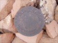
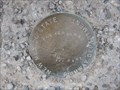 view gallery view galleryN10.8 km |  226 - NMHD 226 - NMHD
in U.S. Benchmarks Set in the parkinglot of the Continental Divide Post Office. posted by: ChapterhouseInc location: New Mexico date approved: 11/02/2010 last visited: 01/18/2014 |
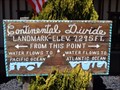
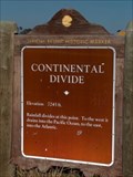
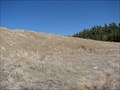
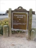 view gallery view galleryN10.8 km |  Continental Divide Continental Divide
in New Mexico Historical Markers One of two identical markers found on either side of I40 along a large ridge. posted by: ChapterhouseInc location: New Mexico date approved: 10/31/2010 last visited: 02/01/2020 |
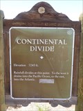
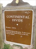
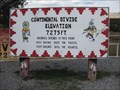
 view gallery view galleryN10.8 km |  7245 ft - Continental Divide, NM 7245 ft - Continental Divide, NM
in Elevation Signs One of two identical markers found on either side of I40 along a large ridge. posted by: ChapterhouseInc location: New Mexico date approved: 10/31/2010 last visited: 02/01/2020 |
 view gallery view galleryN10.8 km |  Continental Divide, NM Continental Divide, NM
in Wikipedia Entries Continental Divide is a village on Interstate 40 where it crosses the continental divide in New Mexico. posted by: rjmcdonough1 location: New Mexico date approved: 08/26/2020 last visited: never |
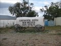 view gallery view galleryN10.8 km |  Covered Wagon - Continental Divide, NM Covered Wagon - Continental Divide, NM
in Covered Wagons One of many notations of the elevation, the wagon is at a gift shop. posted by: ChapterhouseInc location: New Mexico date approved: 11/04/2010 last visited: 10/30/2019 |
 view gallery view galleryN10.8 km |  Continental Divide Trading Post - Continental Divide, New Mexico, USA. Continental Divide Trading Post - Continental Divide, New Mexico, USA.
in Roadside Attractions The Continental Divide at this location is the highest point on Route 66 with an elevation of 7,263 feet. All rain that falls to the left of this location flows into the Pacific, & to the right it flows into the Atlantic, thousands of miles away. posted by: veritas vita location: New Mexico date approved: 02/05/2015 last visited: 10/30/2019 |
 view gallery view galleryN10.8 km | 7275 ft - Continental Divide, NM in Elevation Signs One of many notations of the elevation, the wagon is at a gift shop. posted by: ChapterhouseInc location: New Mexico date approved: 10/31/2010 last visited: 10/30/2019 |
 view gallery view galleryN10.8 km | Continental Divide, New Mexico. 7,295 Feet. in Elevation Signs The Continental Divide at this location is the highest point on Route 66 with an elevation of 7,295 feet. All rain that falls to the left of this location flows into the Pacific, & to the right it flows into the Atlantic, thousands of miles away. posted by: veritas vita location: New Mexico date approved: 10/09/2014 last visited: 08/19/2020 |
 view gallery view galleryN10.8 km |  U.S. 40 - Continental Divide - New Mexico. U.S. 40 - Continental Divide - New Mexico.
in U.S. 40 - The National Road The Continental Divide, is the highest point on US.40 in New Mexico. Two Historic Markers confirm the elevation as 7,263 feet. The markers are located each side of US.40 at Junction 47, McKinley County, New Mexico. posted by: veritas vita location: New Mexico date approved: 07/24/2015 last visited: 02/01/2020 |
 view gallery view galleryN10.8 km |  Historic Route 66 - Continental Divide - New Mexico, USA. Historic Route 66 - Continental Divide - New Mexico, USA.
in National Scenic Byways The Continental Divide at this location is the highest point on Route 66 with an elevation of 7,263 feet. All rain that falls to the left of this location flows into the Pacific, & to the right it flows into the Atlantic, thousands of miles away. posted by: veritas vita location: New Mexico date approved: 10/07/2014 last visited: 10/30/2019 |
 view gallery view galleryN10.8 km |  Highest Point - Route 66 - Continental Divide, New Mexico, USA. Highest Point - Route 66 - Continental Divide, New Mexico, USA.
in Route 66 - The Mother Road The Continental Divide at this location is the highest point on Route 66 with an elevation of 7,263 feet. All rain that falls to the left of this location flows into the Pacific, & to the right it flows into the Atlantic, thousands of miles away. posted by: veritas vita location: New Mexico date approved: 10/08/2014 last visited: 10/30/2019 |
 view gallery view galleryN10.8 km |  Continental Divide - McKinley County, New Mexico, USA. Continental Divide - McKinley County, New Mexico, USA.
in Watershed Markers and Monuments The Continental Divide at this location is the highest point on Route 66 with an elevation of 7,263 feet. All rain that falls to the left of this location flows into the Pacific, & to the right it flows into the Atlantic, thousands of miles away.
Location: New Mexico, United States posted by: veritas vita location: New Mexico date approved: 10/04/2017 last visited: 08/19/2020 |
 view gallery view galleryN10.9 km | 7245 ft - Continental Divide, NM in Elevation Signs One of two identocal markers found on either side of I40 along a large ridge. posted by: ChapterhouseInc location: New Mexico date approved: 10/31/2010 last visited: 05/30/2022 |
 view gallery view galleryN10.9 km | Continental Divide in New Mexico Historical Markers New Mexico Offical Scenic Historical Marker at the Continental Divide. posted by:  Johnny_Quest Johnny_Quest location: New Mexico date approved: 08/09/2008 last visited: 05/30/2022 |
 view gallery view galleryN10.9 km | 7245 ft - Continental Divide, NM in Elevation Signs One of many notations of the elevation in this ridge top town. posted by: ChapterhouseInc location: New Mexico date approved: 10/31/2010 last visited: 02/02/2017 |
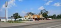
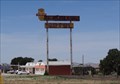 view gallery view gallery NW11.4 km NW11.4 km
| Whiting Brothers Motel and Service Station - Continental Divide, NM in Route 66 - The Mother Road Former Route 66 motel in Continental Divide, NM. posted by: Wallyum location: New Mexico date approved: 05/29/2021 last visited: never |
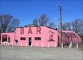 view gallery view gallery E20.3 km E20.3 km
|  Tomahawk Bar Tomahawk Bar
in Quonset Huts Along Route 66 in western New Mexico, the Tomahawk Bar is an operating roadside bar located in a loud-pink quonset hut. It's hard to miss. I'll bet it even glows in the dark! posted by: TravisGood location: New Mexico date approved: 03/18/2007 last visited: 07/21/2010 |
 view gallery view galleryE20.3 km | Tomahawk Bar in Route 66 - The Mother Road Along Route 66 east of Gallup, New Mexico, the Tomahawk Bar is an operating roadside bar located in a loud-pink quonset hut. posted by: TravisGood location: New Mexico date approved: 03/18/2007 last visited: 04/15/2017 |
 view gallery view galleryE26.2 km | Bowlin's Old Crater Trading Post - Bluewater, NM in Route 66 - The Mother Road Abandoned trading post on Route 66 in Bluewater, New Mexico. posted by: Wallyum location: New Mexico date approved: 05/15/2021 last visited: never |
 view gallery view gallery SW28.8 km SW28.8 km
|  Ramah Lake Dam - Ramah, New Mexico Ramah Lake Dam - Ramah, New Mexico
in Water Dams What started as an irrigation dike in the late 1890's is now an earthen dam on the Zuni River. posted by: linkys location: New Mexico date approved: 04/01/2008 last visited: never |
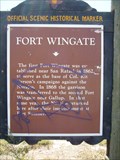 view gallery view galleryNW29.1 km | Fort Wingate in New Mexico Historical Markers A New Mexico OSHM near the town of Red Rock. posted by: leadhiker location: New Mexico date approved: 06/11/2011 last visited: 01/18/2014 |
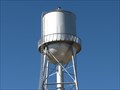 view gallery view gallerySW29.6 km |  Ramah Water Tower - Ramah, New Mexico Ramah Water Tower - Ramah, New Mexico
in Water Towers Small water tower in a small New Mexico town. posted by: linkys location: New Mexico date approved: 03/31/2008 last visited: 07/28/2014 |
 view gallery view gallerySW29.6 km | Cadastral Disk in Ramah, NM in U.S. Benchmarks Bureau of Land Management Cadastral Survey Disc on an exercise trail in the community of Ramah, New Mexico, USA posted by: Hawikuh location: New Mexico date approved: 07/23/2009 last visited: never |
 view gallery view gallerySW30.1 km |  The Pioneer Gardener - Ramah, New Mexico The Pioneer Gardener - Ramah, New Mexico
in Figurative Public Sculpture Bronze life size sculpture a woman and child gardening. posted by: linkys location: New Mexico date approved: 04/01/2008 last visited: 05/10/2012 |
|