 view gallery view gallery N1.6 km N1.6 km
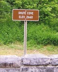
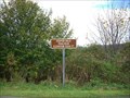
|   Shute Cove - Graham County, NC - 2,660 feet Shute Cove - Graham County, NC - 2,660 feet
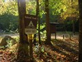
in Elevation Signs The Cherohala Skyway between North Carolina and Tennessee travels through the Cherokee National Forest posted by:  YoSam. YoSam. location: North Carolina date approved: 12/04/2017 last visited: never |
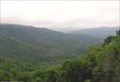
 view gallery view galleryN1.6 km |  Shute Cove - near Robbinsville, NC Shute Cove - near Robbinsville, NC
in Scenic Roadside Look-Outs Along the Cherohala Highway.... posted by: YoSam. location: North Carolina date approved: 12/09/2017 last visited: never |
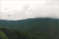
 view gallery view galleryN1.6 km |  Surviving In These Rugged Mountains - Shute Cove - near Robbinsville, NC Surviving In These Rugged Mountains - Shute Cove - near Robbinsville, NC
in Signs of History Historic marker pointing out what pioneers here had to deal with posted by: YoSam. location: North Carolina date approved: 12/06/2017 last visited: never |
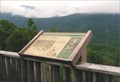
 view gallery view galleryN1.6 km |  Shute Cove - Graham County, NC Shute Cove - Graham County, NC
in Satellite Imagery Oddities Scenic overlook, and satellite view of deer harvest sites inside the cove posted by: YoSam. location: North Carolina date approved: 12/07/2017 last visited: never |
 view gallery view gallery W6.1 km W6.1 km
| Hooper Bald Trailhead - 5205ft in Elevation Signs Another pull off along the Cherohala Skyway posted by:  fatcat161 fatcat161 location: North Carolina date approved: 10/07/2009 last visited: 03/18/2013 |
 view gallery view galleryW8.2 km |  Big Junction Summit Big Junction Summit
in Mountain Summits Big Junction is a mountain summit in Graham County in the state of North Carolina (NC). posted by: fatcat161 location: North Carolina date approved: 10/07/2008 last visited: 03/18/2013 |
 view gallery view galleryW9.7 km | Unicoi Crest - 4594 ft in Elevation Signs Along the Cherohala Skyway on the NC side. posted by: fatcat161 location: North Carolina date approved: 10/07/2009 last visited: 08/13/2020 |
 view gallery view galleryW10 km | Beech Gap - 4501 ft in Elevation Signs This elevation marker on the Cherohala Skyway is at the state line between North Carolina and Tennesse. posted by: fatcat161 location: North Carolina date approved: 10/07/2009 last visited: 03/18/2013 |
 view gallery view gallery E11.4 km E11.4 km
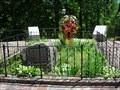
|  Junaluska and Nicie Gravesite - Robbinsville, NC Junaluska and Nicie Gravesite - Robbinsville, NC
in Trail of Tears Junaluska Museum is located on Junaluska Rd in Robbinsville, NC posted by: nomadwillie location: North Carolina date approved: 05/17/2011 last visited: 05/22/2008 |
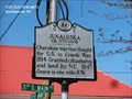
 view gallery view galleryE11.6 km |  Junaluska - Robbinsville NC Junaluska - Robbinsville NC
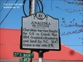
in Civil Rights Memorials Junaluska ca. 1779 - 1858 Cherokee warrior, fought for U.S. in Creek War, 1814. Granted citizenship and land by N.C., 1847. Grave is one mile S.W. posted by: Don.Morfe location: North Carolina date approved: 03/18/2023 last visited: 03/17/2023 |
 view gallery view galleryE11.6 km |  Junaluska Junaluska
in North Carolina Historical Markers Junaluska ca. 1779 - 1858 Cherokee warrior, fought for U.S. in Creek War, 1814. Granted citizenship and land by N.C., 1847. Grave is one mile S.W. posted by: Don.Morfe location: North Carolina date approved: 04/02/2020 last visited: 10/23/2021 |
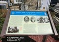
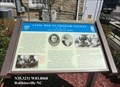 view gallery view galleryE11.7 km |  Civil War in Graham County Union and Confederate Raiders - Robbinsville NC Civil War in Graham County Union and Confederate Raiders - Robbinsville NC
in Civil War Discovery Trail Sites During the Civil War, Graham Country (the part of Cherokee County) offered scant support to the secessionist cause, although both ardent Confederates and staunch Unionists lived here. posted by: Don.Morfe location: North Carolina date approved: 05/02/2020 last visited: 10/08/2021 |
 view gallery view galleryE11.7 km | Civil War in Graham County - Robbinsville NC in U.S. Civil War Sites During the Civil War, Graham Country (the part of Cherokee County) offered scant support to the secessionist cause, although both ardent Confederates and staunch Unionists lived here. The region was not financially dependent on slavery. posted by: Don.Morfe location: North Carolina date approved: 04/25/2023 last visited: 04/25/2023 |
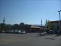 view gallery view galleryE12.1 km |  Robbinsville McDonalds Robbinsville McDonalds
in McDonald's Restaurants Mc Donalds in Robbinsville NC. posted by: fatcat161 location: North Carolina date approved: 10/11/2008 last visited: 07/20/2008 |
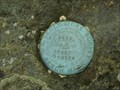 view gallery view gallery SE13.4 km SE13.4 km
|  Tatham Gap USGS Benchmark Tatham Gap USGS Benchmark
in U.S. Benchmarks Elevation BM on the Tatham Gap Road between Andrews and Robbinsville, NC. posted by: paul-3 location: North Carolina date approved: 05/05/2012 last visited: never |
 view gallery view gallerySE13.4 km | Tatham Gap Rd-highest point. Part of Trail of Tears. in Trail of Tears High point of Tatham Gap Rd. El: 3645' posted by: paul-3 location: North Carolina date approved: 05/05/2012 last visited: never |
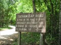 view gallery view gallerySE15.4 km | Tatham Gap Rd. Part of the Trail of Tears in Trail of Tears Sign showing the end of the Tatham Gap Rd. posted by: paul-3 location: North Carolina date approved: 05/05/2012 last visited: never |
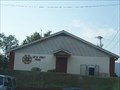 view gallery view gallerySE16.3 km |  Post 7620 - Andrews, NC Post 7620 - Andrews, NC
in VFW Posts VFW Post 7620 is located in Andrews, NC. posted by: lilluckyclover location: North Carolina date approved: 09/21/2007 last visited: 09/13/2007 |
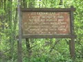
 view gallery view gallery NW16.3 km NW16.3 km
|  Citico Creek Area 13 Citico Creek Area 13
in Free Campsites Area 13 posted by: Better Half location: Tennessee date approved: 11/01/2007 last visited: 03/18/2013 |
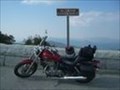
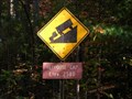
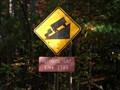
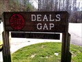 view gallery view galleryN16.7 km | Deals Gap, North Carolina (Dragon's Tail) in Elevation Signs Deals Gap, North Carolina Elevation 1756 Ft posted by: Rat Rat location: North Carolina date approved: 04/12/2011 last visited: 03/27/2024 |
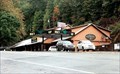
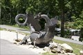
 view gallery view galleryN16.7 km |  Tail of the Dragon - Deals Gap, North Carolina Tail of the Dragon - Deals Gap, North Carolina
in Roadside Attractions It’s the two-lane stretch of U.S. 129 to the north. Its 318 curves in 11 miles earned it the name Tail of the Dragon. posted by: YoSam. location: North Carolina date approved: 02/10/2019 last visited: 04/10/2014 |
 view gallery view galleryN16.7 km |  Deals Gap, North Carolina Deals Gap, North Carolina
in Wikipedia Entries The Dragon two-lane stretch of U.S. 129 to the north. Its 318 curves in 11 miles earned it the name Tail of the Dragon. posted by: YoSam. location: North Carolina date approved: 02/11/2019 last visited: never |
 view gallery view galleryN16.7 km |  The Dragon: Super-twisty N.C. Road is the Ultimate Fall Ride The Dragon: Super-twisty N.C. Road is the Ultimate Fall Ride
in News Article Locations It’s the two-lane stretch of U.S. 129 to the north. Its 318 curves in 11 miles earned it the name Tail of the Dragon. posted by: YoSam. location: North Carolina date approved: 02/10/2019 last visited: 03/27/2024 |
 view gallery view galleryNW17.2 km | Beehouse Gap ~2580 Elevation in Elevation Signs Beehouse Gap posted by: Better Half location: Tennessee date approved: 11/01/2007 last visited: never |
 view gallery view galleryNW17.2 km |  Beehouse Gap Beehouse Gap
in Named Mountain Gaps Cherokee National Forest posted by: Better Half location: Tennessee date approved: 11/01/2007 last visited: never |
|