 view gallery view gallery S2.7 km S2.7 km
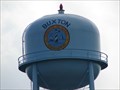
|   Buxton Water Tower Buxton Water Tower
in Water Towers Buxton Water Tower stands near Cape Hatteras Light House. posted by:  VirginiaSeeker VirginiaSeeker location: North Carolina date approved: 07/30/2006 last visited: 06/09/2011 |
 view gallery view gallery SE3.2 km SE3.2 km
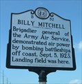
|  Billy Mitchell, Marker B-32 Billy Mitchell, Marker B-32
in North Carolina Historical Markers Military aviation pioneer, General Billy Mitchell conducted bombing tests of WWI German and decommissioned U.S. warships off the coast of North Carolina in 1923. posted by:  showbizkid showbizkid location: North Carolina date approved: 07/04/2006 last visited: 08/09/2016 |
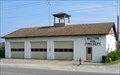 view gallery view gallerySE3.2 km |  Buxton Vol Fire Dept Buxton Vol Fire Dept
in Firehouses Buxton Volunteer Fire Dept is located in the center of Buxton near the Cape Hatteras Lighthouse. posted by: VirginiaSeeker location: North Carolina date approved: 07/30/2006 last visited: 06/03/2013 |
 view gallery view gallerySE3.2 km | R.A. Fessenden, Marker B-53 in North Carolina Historical Markers Reginald Fessenden is a man often referred to as the “Father of Radio Broadcasting.” One of the watershed events in the history of radio broadcasting occurred near the location of this marker in 1902. posted by: showbizkid location: North Carolina date approved: 06/26/2006 last visited: 08/09/2016 |
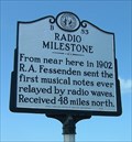 view gallery view gallerySE3.2 km |  FIRST - Musical Notes Ever Relayed by Radio Waves FIRST - Musical Notes Ever Relayed by Radio Waves
in First of its Kind One of the watershed firsts in the history of radio broadcasting occurred near the location of this marker in 1902 - Reginald Fessenden's transmission of musical notes by radio. posted by: showbizkid location: North Carolina date approved: 07/04/2006 last visited: 08/09/2016 |
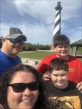
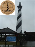
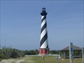
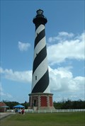 view gallery view gallerySE3.4 km | Cape Hatteras Lighthouse, Marker B-54 in North Carolina Historical Markers The Cape Hatteras Lighthouse on North Carolina's Outer Banks is probably the most recognizable lighthouse in the state, perhaps in the nation. It is the tallest brick lighthouse in the country. The lighthouse is operated by the National Parks Service and is open every day except Christmas. Visiting the grounds is free. The tower may be climbed for a fee.
posted by: showbizkid location: North Carolina date approved: 06/28/2006 last visited: 09/27/2022 |
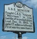 view gallery view gallerySE3.4 km | USS Monitor, Marker B-50 in North Carolina Historical Markers Marker honors the first Union ironclad warship, the USS Monitor. This ship engaged in the first clash between two ironclad ships in March 1862 during the Civil War. The Monitor sank in a storm in December 1862. posted by: showbizkid location: North Carolina date approved: 07/27/2006 last visited: 08/09/2016 |
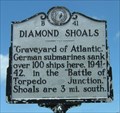 view gallery view gallerySE3.5 km | Diamond Shoals, Marker B-41 in North Carolina Historical Markers Diamond Shoals was the focal point of concentrated and unrestricted German U-boat attacks on shipping off the coast of the Outer Banks during the early years of World War II. posted by: showbizkid location: North Carolina date approved: 07/27/2006 last visited: 08/09/2016 |
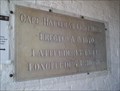
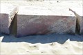 view gallery view gallerySE4.5 km |  Cape Hatteras Light House original site Cape Hatteras Light House original site
in Preserved Architectural Remnants and Ruins Cape Hatteras Light House original site foundation stones. posted by: kJfishman location: North Carolina date approved: 03/28/2008 last visited: 05/14/2023 |
 view gallery view galleryS4.7 km |  Hatteras Lighthouse Hatteras Lighthouse
in Look-Out Towers One of the beautiful lighthouses of NC posted by: TeamRCNC location: North Carolina date approved: 05/08/2021 last visited: 09/27/2022 |
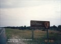 view gallery view galleryS4.7 km |  Cape Hatteras National Seashore - Buxton NC Cape Hatteras National Seashore - Buxton NC
in National Parks of the World Cape Hatteras National Seashore is a United States national seashore which preserves the portion of the Outer Banks of North Carolina from Bodie Island to Ocracoke Island, stretching over 70 miles, and is managed by the National Park Service. posted by: Don.Morfe location: North Carolina date approved: 09/29/2022 last visited: 05/13/2023 |
 view gallery view galleryS4.7 km |  Cape Hatteras National Seashore - Buxton NC Cape Hatteras National Seashore - Buxton NC
in Official Local Tourism Attractions Cape Hatteras National Seashore is a United States national seashore which preserves the portion of the Outer Banks of North Carolina from Bodie Island to Ocracoke Island, stretching over 70 miles, and is managed by the National Park Service. posted by: Don.Morfe location: North Carolina date approved: 09/27/2022 last visited: 05/14/2023 |
 view gallery view galleryS4.7 km |  Cape Hatteras National Seashore - Buxton NC Cape Hatteras National Seashore - Buxton NC
in Wikipedia Entries Cape Hatteras National Seashore is a United States national seashore which preserves the portion of the Outer Banks of North Carolina from Bodie Island to Ocracoke Island, stretching over 70 miles, and is managed by the National Park Service. posted by: Don.Morfe location: North Carolina date approved: 09/26/2022 last visited: 09/27/2022 |
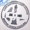
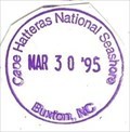 view gallery view galleryS4.7 km |  Cape Hatteras National Seashore - Buxton, NC Cape Hatteras National Seashore - Buxton, NC
in NPS Passport Cancellation Stations Cape Hatteras National Seashore -The sound of ocean waves, the starry night sky, or the calm of the salt marshes, you can experience it all. posted by: Don.Morfe location: North Carolina date approved: 02/14/2020 last visited: 10/10/2021 |
 view gallery view galleryS4.7 km |  Ranger Station at the Cape Hatteras National Seashore - Buxton NC Ranger Station at the Cape Hatteras National Seashore - Buxton NC
in Ranger Stations This Ranger Station is located at the Cape Hatteras Light Station in Buxton NC. There are three visitor centers, each located on a barrier island. There one may obtain a NPS cancellation stamp. posted by: Don.Morfe location: North Carolina date approved: 09/27/2022 last visited: 09/27/2022 |
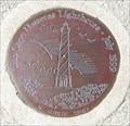
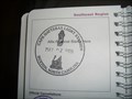 view gallery view galleryS4.7 km |  Cape Hatteras Light Station - Manteo, NC Cape Hatteras Light Station - Manteo, NC
in Lighthouse Passport Stamps Cape Hatteras Light Station stamp at Hatteras Island Visitor Center. posted by: fatcat161 location: North Carolina date approved: 07/07/2010 last visited: 07/07/2016 |
 view gallery view galleryS4.7 km | Cape Hatteras Light Station in NPS Passport Cancellation Stations Cape Hatteras Light Station stamp at Hatteras Island Visitor Center. posted by: GwynEvie location: North Carolina date approved: 02/02/2009 last visited: 07/06/2016 |
 view gallery view galleryS4.7 km |  Cape Hatteras Light House NC Geodetic Survey Cape Hatteras Light House NC Geodetic Survey
in U.S. Benchmarks Cape Hatteras Light House NC Geodetic Survey posted by: kJfishman location: North Carolina date approved: 03/23/2008 last visited: 05/18/2016 |
 view gallery view galleryS4.7 km |  Cape Hatteras Light House NC Geodetic Survey Cape Hatteras Light House NC Geodetic Survey
in U.S. Historic Survey Stones and Monuments Cape Hatteras Light House NC Geodetic Survey posted by: kJfishman location: North Carolina date approved: 03/22/2008 last visited: 10/24/2023 |
 view gallery view galleryS4.7 km |  No. 136, Cape Hatteras Lighthouse - Hatteras Island, NC No. 136, Cape Hatteras Lighthouse - Hatteras Island, NC
in Tourist Stamps Photos The Cape Hatteras Lighthouse is the 23rd tallest traditional lighthouse in the world. posted by: Marine Biologist location: North Carolina date approved: 10/20/2011 last visited: 06/29/2015 |
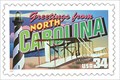 view gallery view galleryS4.7 km |  Greetings from North Carolina - Cape Hatteras Lighthouse - Hatteras Island, NC Greetings from North Carolina - Cape Hatteras Lighthouse - Hatteras Island, NC
in Philatelic Photographs The Greetings from North Carolina postage stamp includes an image of the Cape Hatteras Lighthouse on Hatteras Island, North Carolina, USA. posted by: Marine Biologist location: North Carolina date approved: 11/27/2011 last visited: 06/15/2015 |
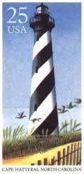 view gallery view galleryS4.7 km | Cape Hatteras Lighthouse - Cape Hatteras, NC in Philatelic Photographs The United States Post Office's first series of lighthouse stamps was issued in 1990 and sold for 25 cents each. This postage stamp honors the great American Cape Hatteras Lighthouse (North Carolina). posted by: fatcat161 location: North Carolina date approved: 10/16/2009 last visited: 06/29/2015 |
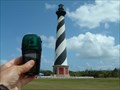
 view gallery view galleryS4.7 km |  N35 15' 14" W075 30' 56" - Hatteras Lighthouse - Buxton, NC N35 15' 14" W075 30' 56" - Hatteras Lighthouse - Buxton, NC
in Permanent Geographic Coordinates Don't expect to find the waymark at the "permanent" geographic coordinates. The Hatteras Lighthouse where the coordinate marker is located was moved in 1999 to protect the historic structure from an eroding shoreline. posted by: Scooter Bill location: North Carolina date approved: 05/11/2009 last visited: 06/29/2015 |
 view gallery view galleryS4.7 km |  The Big Move - Cape Hatteras, NC The Big Move - Cape Hatteras, NC
in News Article Locations On June 5, 1999 The National Park Service began moving the lighthouse and its outbuildings 2900 feet. posted by: fatcat161 location: North Carolina date approved: 10/16/2009 last visited: 05/14/2023 |
 view gallery view galleryS4.7 km |  Cape Hatteras Lighthouse, North Carolina Cape Hatteras Lighthouse, North Carolina
in Coastal Lighthouses The Cape Hatteras Lighthouse on North Carolina's Outer Banks is probably the most recognizable lighthouse in the state, perhaps in the nation. It is the tallest brick lighthouse in the country. When the erosion from the encroaching Atlantic Ocean threatened to topple Hatteras, the tower was relocated about 2900 feet, an engineering feat that produced some national awards. The lighthouse is operated by the National Parks Service. Visiting the grounds is free. Tower may be climbed for a fee. posted by: showbizkid location: North Carolina date approved: 06/26/2006 last visited: 05/14/2023 |
|