 view gallery view gallery NE12.4 km NE12.4 km
|   Tomahawk Bar Tomahawk Bar
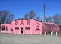
in Route 66 - The Mother Road Along Route 66 east of Gallup, New Mexico, the Tomahawk Bar is an operating roadside bar located in a loud-pink quonset hut. posted by:  TravisGood TravisGood location: New Mexico date approved: 03/18/2007 last visited: 04/15/2017 |
 view gallery view galleryNE12.4 km |  Tomahawk Bar Tomahawk Bar
in Quonset Huts Along Route 66 in western New Mexico, the Tomahawk Bar is an operating roadside bar located in a loud-pink quonset hut. It's hard to miss. I'll bet it even glows in the dark! posted by: TravisGood location: New Mexico date approved: 03/18/2007 last visited: 07/21/2010 |
 view gallery view gallery E12.4 km E12.4 km
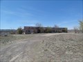
| Bowlin's Old Crater Trading Post - Bluewater, NM in Route 66 - The Mother Road Abandoned trading post on Route 66 in Bluewater, New Mexico. posted by: Wallyum location: New Mexico date approved: 05/15/2021 last visited: never |
 view gallery view gallery SE22.2 km SE22.2 km
|  Milan, New Mexico 6520' Milan, New Mexico 6520'
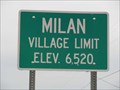
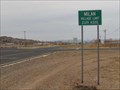
in Elevation Signs Sign for small town on Historic Route 66 that shows its elevation. posted by: linkys location: New Mexico date approved: 11/12/2009 last visited: 07/21/2010 |
 view gallery view gallerySE22.2 km |  Milan, New Mexico Milan, New Mexico
in Small Town, Big Name It's a long ways from Italy. posted by: linkys location: New Mexico date approved: 11/12/2009 last visited: 04/23/2014 |
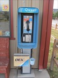 view gallery view gallerySE22.4 km |  Bar S Payphone - Milan, NM Bar S Payphone - Milan, NM
in Payphones Payphone in front of the Bar S RV Park behind the Loves Truckstop in Milan, New Mexico. posted by: linkys location: New Mexico date approved: 11/14/2009 last visited: 05/14/2021 |
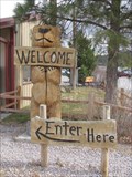 view gallery view gallerySE22.4 km |  A Welcoming Bear - Milan, NM A Welcoming Bear - Milan, NM
in Bear Statues Bear statue in front of the Bar S RV Park behind the Loves Truckstop in Milan, New Mexico. posted by: linkys location: New Mexico date approved: 11/18/2009 last visited: never |
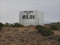 view gallery view gallerySE23 km |  Village of Milan, New Mexico - Water Tower Village of Milan, New Mexico - Water Tower
in Water Towers Water tank is situated on a hill above the Historic Route 66 town. posted by: linkys location: New Mexico date approved: 11/12/2009 last visited: 05/14/2021 |
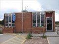
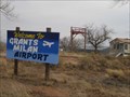 view gallery view gallerySE23.5 km |  Grants-Milan Municipal Airport - Grants, NM Grants-Milan Municipal Airport - Grants, NM
in Airports Small town municipal airport posted by: linkys location: New Mexico date approved: 11/15/2009 last visited: 05/14/2021 |
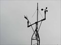 view gallery view gallerySE23.5 km |  Grants Milan Municipal Airport - Grants, NM Grants Milan Municipal Airport - Grants, NM
in Weather Stations Official NOAA weather station for Grants, NM. posted by: linkys location: New Mexico date approved: 11/14/2009 last visited: 05/14/2021 |
 view gallery view gallery NW23.8 km NW23.8 km
|  Continental Divide, NM 87312 Continental Divide, NM 87312
in U.S. Post Offices Located near I40 atop the New Mexico stretch of the Continental Divide. posted by:  ChapterhouseInc ChapterhouseInc location: New Mexico date approved: 10/31/2010 last visited: 05/10/2012 |
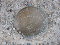 view gallery view galleryNW23.8 km |  226 - NMHD 226 - NMHD
in U.S. Benchmarks Set in the parkinglot of the Continental Divide Post Office. posted by: ChapterhouseInc location: New Mexico date approved: 11/02/2010 last visited: 01/18/2014 |
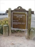 view gallery view galleryNW23.8 km |  Continental Divide Continental Divide
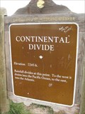
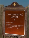
in New Mexico Historical Markers One of two identical markers found on either side of I40 along a large ridge. posted by: ChapterhouseInc location: New Mexico date approved: 10/31/2010 last visited: 02/01/2020 |
 view gallery view galleryNW23.8 km | 7245 ft - Continental Divide, NM in Elevation Signs One of two identical markers found on either side of I40 along a large ridge. posted by: ChapterhouseInc location: New Mexico date approved: 10/31/2010 last visited: 02/01/2020 |
 view gallery view galleryNW23.8 km | 7275 ft - Continental Divide, NM in Elevation Signs One of many notations of the elevation, the wagon is at a gift shop. posted by: ChapterhouseInc location: New Mexico date approved: 10/31/2010 last visited: 10/30/2019 |
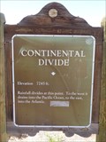
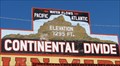
 view gallery view galleryNW23.8 km | Continental Divide, New Mexico. 7,295 Feet. in Elevation Signs The Continental Divide at this location is the highest point on Route 66 with an elevation of 7,295 feet. All rain that falls to the left of this location flows into the Pacific, & to the right it flows into the Atlantic, thousands of miles away. posted by: veritas vita location: New Mexico date approved: 10/09/2014 last visited: 08/19/2020 |
 view gallery view galleryNW23.8 km |  U.S. 40 - Continental Divide - New Mexico. U.S. 40 - Continental Divide - New Mexico.
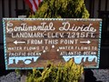
in U.S. 40 - The National Road The Continental Divide, is the highest point on US.40 in New Mexico. Two Historic Markers confirm the elevation as 7,263 feet. The markers are located each side of US.40 at Junction 47, McKinley County, New Mexico. posted by: veritas vita location: New Mexico date approved: 07/24/2015 last visited: 02/01/2020 |
 view gallery view galleryNW23.8 km |  Historic Route 66 - Continental Divide - New Mexico, USA. Historic Route 66 - Continental Divide - New Mexico, USA.
in National Scenic Byways The Continental Divide at this location is the highest point on Route 66 with an elevation of 7,263 feet. All rain that falls to the left of this location flows into the Pacific, & to the right it flows into the Atlantic, thousands of miles away. posted by: veritas vita location: New Mexico date approved: 10/07/2014 last visited: 10/30/2019 |
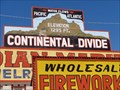
 view gallery view galleryNW23.8 km | Highest Point - Route 66 - Continental Divide, New Mexico, USA. in Route 66 - The Mother Road The Continental Divide at this location is the highest point on Route 66 with an elevation of 7,263 feet. All rain that falls to the left of this location flows into the Pacific, & to the right it flows into the Atlantic, thousands of miles away. posted by: veritas vita location: New Mexico date approved: 10/08/2014 last visited: 10/30/2019 |
 view gallery view galleryNW23.8 km |  Covered Wagon - Continental Divide, NM Covered Wagon - Continental Divide, NM
in Covered Wagons One of many notations of the elevation, the wagon is at a gift shop. posted by: ChapterhouseInc location: New Mexico date approved: 11/04/2010 last visited: 10/30/2019 |
 view gallery view galleryNW23.8 km |  Continental Divide Trading Post - Continental Divide, New Mexico, USA. Continental Divide Trading Post - Continental Divide, New Mexico, USA.
in Roadside Attractions The Continental Divide at this location is the highest point on Route 66 with an elevation of 7,263 feet. All rain that falls to the left of this location flows into the Pacific, & to the right it flows into the Atlantic, thousands of miles away. posted by: veritas vita location: New Mexico date approved: 02/05/2015 last visited: 10/30/2019 |
 view gallery view galleryNW23.8 km |  Continental Divide - McKinley County, New Mexico, USA. Continental Divide - McKinley County, New Mexico, USA.
in Watershed Markers and Monuments The Continental Divide at this location is the highest point on Route 66 with an elevation of 7,263 feet. All rain that falls to the left of this location flows into the Pacific, & to the right it flows into the Atlantic, thousands of miles away.
Location: New Mexico, United States posted by: veritas vita location: New Mexico date approved: 10/04/2017 last visited: 08/19/2020 |
 view gallery view galleryNW23.8 km |  Continental Divide, NM Continental Divide, NM
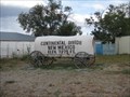
in Wikipedia Entries Continental Divide is a village on Interstate 40 where it crosses the continental divide in New Mexico. posted by: rjmcdonough1 location: New Mexico date approved: 08/26/2020 last visited: never |
 view gallery view galleryNW24 km | 7245 ft - Continental Divide, NM in Elevation Signs One of two identocal markers found on either side of I40 along a large ridge. posted by: ChapterhouseInc location: New Mexico date approved: 10/31/2010 last visited: 05/30/2022 |
 view gallery view galleryNW24 km | Continental Divide in New Mexico Historical Markers New Mexico Offical Scenic Historical Marker at the Continental Divide. posted by: Johnny_Quest location: New Mexico date approved: 08/09/2008 last visited: 05/30/2022 |
|