 view gallery view gallery SE5.6 km SE5.6 km
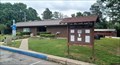
|   Elm Park Rest Area - Elm Park, AR Elm Park Rest Area - Elm Park, AR
in Highway Rest Areas This small rest area is on the east side of Highway 71, just north of Elm Park, Arkansas. posted by:  The Snowdog The Snowdog location: Arkansas date approved: 06/03/2023 last visited: never |
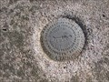
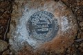
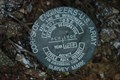
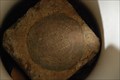
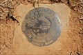
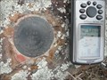 view gallery view gallerySE6.6 km |  FH0839: K 299 - Elm Park AR FH0839: K 299 - Elm Park AR
in U.S. Benchmarks This Benchmark is 150 feet northwest of US Hwy 71 and State Hwy 378 near Elm Park, Arkansas. posted by: PeterNoG location: Arkansas date approved: 09/29/2013 last visited: 01/23/2009 |
 view gallery view gallery S7.4 km S7.4 km
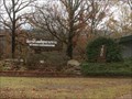
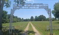
|  Freedom Cemetery - Scott County, AR Freedom Cemetery - Scott County, AR
in Worldwide Cemeteries This beautiful and well-tended rural cemetery is about six miles north of Waldron, Arkansas. posted by: The Snowdog location: Arkansas date approved: 06/03/2023 last visited: never |
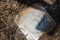
 view gallery view galleryS7.4 km |  Darla McDaniel - Freedom Cemetery, Scott County, AR Darla McDaniel - Freedom Cemetery, Scott County, AR
in Homemade Tombstones Two home-made grave markers for members of the McDaniel Family are just to the left of the entrance of Freedom Cemetery - in Scott County, Arkansas. posted by: The Snowdog location: Arkansas date approved: 06/12/2023 last visited: never |
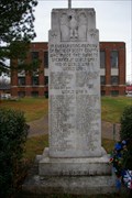 view gallery view galleryS20 km |  WW1 Monument Waldron AR WW1 Monument Waldron AR
in World War I Memorials and Monuments WW1 Monument Waldron AR Honoring those from Scott County who gave their lives. posted by: kJfishman location: Arkansas date approved: 01/07/2009 last visited: 01/07/2009 |
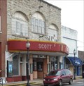 view gallery view galleryS20.1 km |  Scott Theater - Waldron AR Scott Theater - Waldron AR
in Vintage Movie Theaters Scott Theater - Waldron AR built in 1930 posted by: kJfishman location: Arkansas date approved: 01/07/2009 last visited: 01/07/2009 |
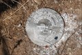
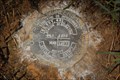
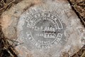
 view gallery view gallery SW23.3 km SW23.3 km
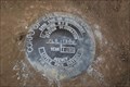
|  Poteau Azimuth 1935 Arkansas Poteau Azimuth 1935 Arkansas
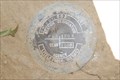
in Azimuth Benchmarks An Azimuth Mark of The Poteau Triangulation Station that the surface mark has been marked as Destroyed by NGS. A data sheet for the Station is not available at NGS or geocaching.com. posted by: Cardinal location: Arkansas date approved: 04/17/2008 last visited: never |
 view gallery view gallery NW27.8 km NW27.8 km
|  Buddhist Temple, Greenwood, Ark Buddhist Temple, Greenwood, Ark
in Buddhist Temples and Public Shrines This Buddhist temple attracts Laotian and Cambodian worshippers from the surrounding four states. posted by: sagefemme location: Arkansas date approved: 12/01/2015 last visited: never |
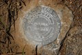
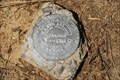
 view gallery view galleryNW28.6 km | FC BDY 413 in U.S. Benchmarks A standard metal disk set in concrete posted by: secondgunman location: Arkansas date approved: 08/07/2010 last visited: never |
 view gallery view galleryNW28.8 km | FC BDY 501 in U.S. Benchmarks A standard metal disk set in concrete. posted by: secondgunman location: Arkansas date approved: 08/07/2010 last visited: never |
 view gallery view galleryNW28.8 km | 97-FC-15 in U.S. Benchmarks A standard metal disk set in concrete posted by: secondgunman location: Arkansas date approved: 08/07/2010 last visited: never |
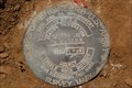 view gallery view galleryNW28.8 km | FC BDY 502 in U.S. Benchmarks The mark is a standard metal disk. posted by: secondgunman location: Arkansas date approved: 08/07/2010 last visited: never |
 view gallery view galleryNW29 km | FC BDY 503 in U.S. Benchmarks The mark is a 9cm metal disk set in a concrete square 12cm on a side. posted by: secondgunman location: Arkansas date approved: 08/29/2010 last visited: never |
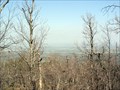 view gallery view gallery W29.1 km W29.1 km
|  Sugarloaf Mountain, Oklahoma Sugarloaf Mountain, Oklahoma
in Mountain Summits The highest point in LeFlore County, Oklahoma. Sugarloaf Mountain is home to a benchmark and a geocache as well.
See the geocache: http://www.geocaching.com/seek/cache_details.aspx?guid=c23778e3-ec35-4fa1-ad36-be565f099d2e posted by: MadDog Family location: Oklahoma date approved: 08/17/2005 last visited: 03/03/2013 |
 view gallery view galleryNW29.1 km | FC BDY 503A in U.S. Benchmarks The mark is a 9cm metal disk set in concrete flush with the ground and approximately 1.5m below the level of the Blvd. posted by: secondgunman location: Arkansas date approved: 08/29/2010 last visited: never |
 view gallery view galleryNW29.1 km | FC BDY 503B in U.S. Benchmarks The mark is a standard disk set in concrete posted by: secondgunman location: Arkansas date approved: 08/07/2010 last visited: never |
 view gallery view galleryNW29.3 km | FC BDY 503D in U.S. Benchmarks The mark is a 9cm metal disk set in a concrete square 12cm on a side. posted by: secondgunman location: Arkansas date approved: 08/20/2010 last visited: never |
 view gallery view galleryNW29.3 km | FC BDY 516 in U.S. Benchmarks The marker is a standard metal disk set in concrete. posted by: secondgunman location: Arkansas date approved: 08/07/2010 last visited: 02/24/2012 |
 view gallery view galleryNW29.5 km | FC BDY 380 RESET in U.S. Benchmarks The mark is a 9cm metal disk set in a concrete square 12cm on a side. posted by: secondgunman location: Arkansas date approved: 08/20/2010 last visited: never |
 view gallery view galleryNW29.5 km | FC BDY 441 in U.S. Benchmarks The marker is a standard metal disc set in concrete. posted by: secondgunman location: Arkansas date approved: 08/06/2010 last visited: never |
 view gallery view gallery N29.5 km N29.5 km
| Measles Memorial Public Cemetery - Lavaca, AR in Worldwide Cemeteries This small cemetery is on the south side of E. Main Street - in Lavaca, Arkansas. posted by: The Snowdog location: Arkansas date approved: 07/27/2022 last visited: never |
 view gallery view galleryNW29.9 km | FC BDY 360 in U.S. Benchmarks The mark is a 9cm metal disk set in a concrete square 12cm on a side. posted by: secondgunman location: Arkansas date approved: 08/20/2010 last visited: never |
 view gallery view galleryNW30.1 km | FC BDY 346 in U.S. Benchmarks The mark is a 9cm metal disk set in a concrete square 12cm on a side. posted by: secondgunman location: Arkansas date approved: 08/29/2010 last visited: never |
 view gallery view galleryNW30.6 km | 97 FC 12 in U.S. Benchmarks The mark is a 9cm metal disk set in a concrete square 12cm on a side. posted by: secondgunman location: Arkansas date approved: 08/29/2010 last visited: 02/23/2012 |
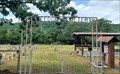
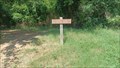 view gallery view galleryNW30.6 km |  Field and Forest Trail - AGFC Janet Huckabee Arkansas River Valley Nature Center - Fort Smith, AR Field and Forest Trail - AGFC Janet Huckabee Arkansas River Valley Nature Center - Fort Smith, AR
in Hiking and walking trailheads This trailhead is at the northwest corner of a parking lot at the AGFC Janet Huckabee Arkansas River Valley Nature Center - in Fort Smith, Arkansas. posted by: The Snowdog location: Arkansas date approved: 09/04/2023 last visited: never |
|