 view gallery view gallery NW10.1 km NW10.1 km
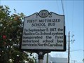
|   First Motorized School Bus ---- C-47 First Motorized School Bus ---- C-47
in North Carolina Historical Markers Located on Broad St. and Church St. in Oriental NC posted by:  Countrydragon Countrydragon location: North Carolina date approved: 01/18/2010 last visited: 01/02/2013 |
 view gallery view galleryNW10.1 km |  First Motorized School Bus in North Carolina First Motorized School Bus in North Carolina
in First of its Kind Located on Broad St. and Church St. in Oriental NC posted by: Countrydragon location: North Carolina date approved: 01/14/2010 last visited: 01/01/2013 |
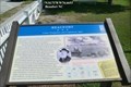
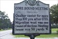 view gallery view gallery SW15.8 km SW15.8 km
| Core Sound Meeting -- C-35 in North Carolina Historical Markers Located on NC-101, Harlowe, NC posted by: Countrydragon location: North Carolina date approved: 01/14/2010 last visited: 12/03/2003 |
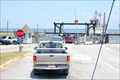 view gallery view gallery W15.8 km W15.8 km
|  Cherry Branch-Minnesott Beach, Nr. Cherry Point, NC Cherry Branch-Minnesott Beach, Nr. Cherry Point, NC
in Ferries and Ferry Landings NC ferry across the Neuse River. Southern terminal. posted by: garmin_geek location: North Carolina date approved: 01/28/2009 last visited: 01/01/2013 |
 view gallery view gallery SE21.7 km SE21.7 km
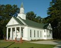
|  Williston United Methodist Church, formerly Springfield Methodist Episcopal Church, Williston, North Carolina Williston United Methodist Church, formerly Springfield Methodist Episcopal Church, Williston, North Carolina
in This Old Church Williston United Methodist Church was orginally called Springfield Methodist Episcopal Church, South and was built in 1883. posted by: showbizkid location: North Carolina date approved: 07/22/2006 last visited: 06/24/2006 |
 view gallery view gallerySE21.7 km | Williston United Methodist Church, Williston, North Carolina in Country Churches Springfield Methodist Episcopal Church was built in 1883. The church is now called Williston United Methodist Church. It is located in the "Down East" community of Williston. posted by: showbizkid location: North Carolina date approved: 07/22/2006 last visited: 06/25/2006 |
 view gallery view galleryNW24.6 km |  Pamlico County Confederate Memorial in Bayboro North Carolina Pamlico County Confederate Memorial in Bayboro North Carolina
in American Civil War Monuments and Memorials This wonderful bronze memorial site on a rounded stone on the left side of Pamlico County Courthouse. It is a reminder to all who pass it that even though these men dead for the southern they were fighting for what they believed in. posted by: Countrydragon location: North Carolina date approved: 01/15/2010 last visited: 01/16/2010 |
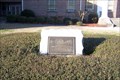
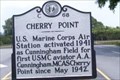 view gallery view galleryW24.9 km | Cherry Point ---- C-68 in North Carolina Historical Markers Located on NC 101 at Cunningham Blvd in Havelock NC posted by: Countrydragon location: North Carolina date approved: 01/14/2010 last visited: 01/01/2013 |
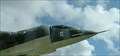 view gallery view galleryW25.4 km |  AV-8A Harrier, Havelock, North Carolina AV-8A Harrier, Havelock, North Carolina
in Static Aircraft Displays This static aircraft display in Havelock, North Carolina has actually become the city seal. Marine Corps Air Station, Cherry Point is located in Havelock. posted by: showbizkid location: North Carolina date approved: 07/02/2006 last visited: 01/01/2013 |
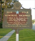 view gallery view galleryW25.4 km |  U.S. Highway 70, Havelock, North Carolina U.S. Highway 70, Havelock, North Carolina
in Blue Star Memorial Highway Markers The Blue Star Memorial Marker in Havelock, North Carolina, home of the Marine Corps Naval Air Station, Cherry Point. posted by: showbizkid location: North Carolina date approved: 07/05/2006 last visited: 08/25/2013 |
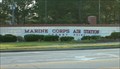 view gallery view galleryW25.4 km |  Marine Corps Air Station, Cherry Point Marine Corps Air Station, Cherry Point
in Military Installations Marine Corps Air Station, Cherry Point is the largest MCAS in the world. It is located in Havelock, North Carolina. More than 49,000 people make up the Cherry Point-related population, including active duty and retired Marines, the civilian workforce, and their dependents. posted by: showbizkid location: North Carolina date approved: 07/22/2006 last visited: 01/01/2013 |
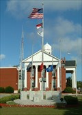 view gallery view gallery S25.6 km S25.6 km
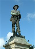
|  Carteret County Veterans Memorial, Beaufort, North Carolina Carteret County Veterans Memorial, Beaufort, North Carolina
in World War I Memorials and Monuments The Carteret County Veterans Memorial honors veterans from World War I forward. posted by: showbizkid location: North Carolina date approved: 07/28/2006 last visited: 10/16/2012 |
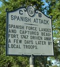 view gallery view galleryS25.6 km | Spanish Attack, Marker C-8 in North Carolina Historical Markers The Spanish Navy harrased and captured Beauford in 1747. They were repulsed, but the need for a coastal fort was apparent and Fort Dobbs was built nearby in 1756. This was later replaced by Fort Macon. posted by: showbizkid location: North Carolina date approved: 07/01/2006 last visited: 07/28/2013 |
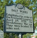 view gallery view galleryS25.6 km | Salt Works, Marker C-13 in North Carolina Historical Markers This marker makes note of a Revolutionary War Salt Works nearby. posted by: showbizkid location: North Carolina date approved: 07/02/2006 last visited: 07/28/2013 |
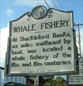 view gallery view galleryS25.6 km | Whale Fishery, Marker C-21 in North Carolina Historical Markers Whaling was never a huge industry in North Carolina. In fact, it was seasonal work for Outer Bankers. posted by: showbizkid location: North Carolina date approved: 07/04/2006 last visited: 07/28/2013 |
 view gallery view galleryS25.7 km | Carteret County Confederate Monument, Beaufort, North Carolina in American Civil War Monuments and Memorials The Civil War Monument for Carteret County is on the grounds of the courthouse in Beaufort. posted by: showbizkid location: North Carolina date approved: 07/02/2006 last visited: 04/10/2023 |
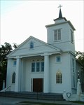 view gallery view galleryS25.7 km | Purvis Chapel, Beaufort, North Carolina in This Old Church Purvis Chapel is the oldest church in continuous use in Beaufort. This church was originally built as a Methodist church and later given to the AME Zion congregation. This church is one of three in Beaufort that border on the Old Burying Ground cemetery. posted by: showbizkid location: North Carolina date approved: 07/26/2006 last visited: 10/16/2012 |
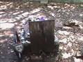 view gallery view galleryS25.7 km |  Wooden Handmade Grave Marker - Old Burying Ground, Beaufort, NC Wooden Handmade Grave Marker - Old Burying Ground, Beaufort, NC
in Homemade Tombstones Hand made wooden grave marker for a child at the old burying grounds in Beaufort, NC. posted by: 79scouts location: North Carolina date approved: 08/01/2010 last visited: 10/16/2012 |
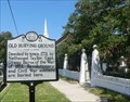
 view gallery view galleryS25.7 km | Old Burying Ground, Marker C-43 in North Carolina Historical Markers The Old Burying Ground is an 18th century cemetery owned by the town of Beaufort since 1731. posted by: showbizkid location: North Carolina date approved: 07/01/2006 last visited: 04/10/2023 |
 view gallery view galleryS25.7 km |  Old Burying Ground Old Burying Ground
in U.S. National Register of Historic Places The Old Burying Ground is an 18th Century cemetery in Beaufort. The coordinates are for the Ann Street gates to the Burying Grounds where a state historic marker located. posted by: showbizkid location: North Carolina date approved: 07/01/2006 last visited: 04/10/2023 |
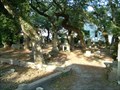
 view gallery view galleryS25.7 km |  Old Burying Ground - Beaufort NC Old Burying Ground - Beaufort NC
in Official Local Tourism Attractions Nestled in the 400 block of Ann Street in Beaufort’s Historic District, the oldest of the town’s cemeteries was established in the early 1700s. posted by: Don.Morfe location: North Carolina date approved: 04/09/2023 last visited: 04/10/2023 |
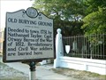
 view gallery view galleryS25.7 km |  Old Burying Ground - Beaufort NC Old Burying Ground - Beaufort NC
in Worldwide Cemeteries Deeded to town, 1731, by Nathanael Taylor. Capt. Otway Burns of the War of 1812, Revolutionary and Civil War soldiers are buried here. posted by: Don.Morfe location: North Carolina date approved: 10/19/2022 last visited: 04/10/2023 |
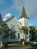 view gallery view galleryS25.9 km | Ann Street United Methodist Church, Beaufort, North Carolina in This Old Church Ann Street United Methodist Church was built in 1854, but the congregation dates back to 1778. posted by: showbizkid location: North Carolina date approved: 07/21/2006 last visited: 04/20/2015 |
 view gallery view galleryS25.9 km | North Carolina Civil War Trail - Beaufort in Civil War Discovery Trail Sites Trail sign in historic Beaufort, NC - Union Occupation and Confederate Spies. posted by: 79scouts location: North Carolina date approved: 08/02/2010 last visited: 04/10/2023 |
 view gallery view galleryS25.9 km | Beaufort Union Occupation and Confederate Spies - Beaufort NC in U.S. Civil War Sites Before the outbreak of the Civil War in 1861, local citizens formed the Beaufort Harbor Guards. These Confederate sympathizers, led by Capt. Josiah Pender, occupied Fort Mason wheb U.S. Army Ordnance Sgt. William Alexander, surrendered. posted by: Don.Morfe location: North Carolina date approved: 04/10/2023 last visited: 04/10/2023 |
|