 view gallery view gallery S0.6 km S0.6 km
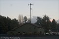
|   Pinewood Fire Department - Munds Park, AZ Pinewood Fire Department - Munds Park, AZ
in Firehouses The Pinewood Fire Dept serves the Munds Park area along I-17 from Stoneman Lake to Kelly Canyon. The Pinewood Volunteer Association was formed in 1973, becoming a Special Fire District in 1976. posted by:  DopeyDuck DopeyDuck location: Arizona date approved: 04/10/2009 last visited: 05/18/2011 |
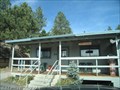
 view gallery view galleryS0.6 km |  Pinewood Country Club - Munds Park, AZ Pinewood Country Club - Munds Park, AZ
in Public and Private Golf Courses The 18-hole Pinewood Golf Course and Country Club has a restaurant, lounge, driving range, pro shop, tennis courts, heated swimming pool, and many organized activities for members. posted by: DopeyDuck location: Arizona date approved: 04/14/2009 last visited: never |
 view gallery view gallery SW1.1 km SW1.1 km
|  Munds Park, AZ 86017 Munds Park, AZ 86017
in U.S. Post Offices Munds Park is a small town south of Flagstaff, AZ. This post office serves only PO Boxes. posted by: DopeyDuck location: Arizona date approved: 01/07/2009 last visited: 05/18/2011 |
 view gallery view gallery W1.1 km W1.1 km
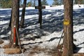
|  Janice Place ATV Trail - Munds Park, AZ Janice Place ATV Trail - Munds Park, AZ
in Offroad Trails This hiking & ATV trail in the Coconino National Forest is maintained by the volunteer Munds Park Trail Stewards (MUTS). There is a large pull-out for parking in front of the trailhead. posted by: DopeyDuck location: Arizona date approved: 01/20/2009 last visited: 06/12/2012 |
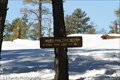 view gallery view galleryW1.1 km |  Munds Park Trail System - Janice Place Forest Access - Munds Park, AZ Munds Park Trail System - Janice Place Forest Access - Munds Park, AZ
in Hiking and walking trailheads This hiking & ATV trail in the Coconino National Forest is maintained by the volunteer Munds Park Trail Stewards (MUTS). There is a large pull-out for parking in front of the trailhead. posted by: DopeyDuck location: Arizona date approved: 01/20/2009 last visited: never |
 view gallery view gallery E1.9 km E1.9 km
| Munds Park/Mormon Lake Trail System - Munds Park, AZ in Offroad Trails This trail head is for the forest roads and network of ATV trails in the Coconino National Forest from Munds Park to Mormon Lake. There is a large parking area for trailers, and a kiosk with information on the 4x4, ATV, and Snowmobile trails. posted by: DopeyDuck location: Arizona date approved: 04/13/2009 last visited: 06/12/2012 |
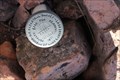
 view gallery view galleryW3.2 km |  AZ Hwy BM - Munds Park, AZ AZ Hwy BM - Munds Park, AZ
in U.S. Benchmarks We stumbled upon this ADOT benchmark set in concrete along a fence while geocaching along Forest Road 9469S behind the rest area. posted by: DopeyDuck location: Arizona date approved: 04/11/2010 last visited: never |
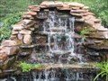 view gallery view galleryW8.9 km |  Oak Creek Waterfall, Sedona, AZ Oak Creek Waterfall, Sedona, AZ
in Man-made Waterfalls A great little fall. posted by:  BackPak BackPak location: Arizona date approved: 11/10/2006 last visited: 10/18/2010 |
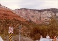
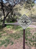 view gallery view galleryW9 km |  Watch for Snakes! N. of Sedona Watch for Snakes! N. of Sedona
in Uncommon Crossing Signs At the entrance to Encinoso Picnic Area is this warning sign to Not run over the snakes! posted by: funsigns location: Arizona date approved: 04/19/2021 last visited: never |
 view gallery view galleryW9 km |  You are Here at North Wilson Trailhead - Coconino National Forest - Sedona, AZ You are Here at North Wilson Trailhead - Coconino National Forest - Sedona, AZ
in 'You Are Here' Maps A detailed You are Here sign is next to parking, at the N. Wilson Mountain Trailhead in Sedona. posted by: Max and 99 location: Arizona date approved: 05/28/2023 last visited: never |
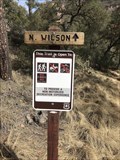 view gallery view galleryW9 km | N. Wilson Trail - Coconino National Forest - Sedona, AZ in Hiking and walking trailheads A 9.9 mile out-and-back trail north of Sedona. posted by: Max and 99 location: Arizona date approved: 05/28/2023 last visited: never |
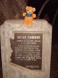 view gallery view gallerySW9 km |  Indian Gardens Indian Gardens
in Arizona Historical Markers Homestead of the first settler in Oak Creek Canyon posted by: Dalphin location: Arizona date approved: 04/30/2007 last visited: 09/09/2019 |
 view gallery view gallery NW10.1 km NW10.1 km
| ES0641: Y 491 1982 (NGS, Oak Creek Canyon, AZ) in U.S. Benchmarks An NGS vertical control mark, located in Oak Creek Canyon, AZ.
The NGS PID# is ES0641. posted by: NH2beers location: Arizona date approved: 01/05/2017 last visited: never |
 view gallery view galleryW10.3 km |  Slide Rock State Park - Arizona Slide Rock State Park - Arizona
in State/Provincial Parks An interesting park with cool rock formations. posted by: OxfordMasterCacher location: Arizona date approved: 04/09/2013 last visited: 02/20/2018 |
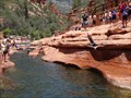 view gallery view galleryW10.3 km |  Slide Rock Swimming Hole, Sedona, Arizona Slide Rock Swimming Hole, Sedona, Arizona
in Swimming Holes Located 6 miles north of Sedona on highway 89A posted by: Lord Mot location: Arizona date approved: 06/18/2013 last visited: 02/20/2018 |
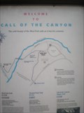 view gallery view galleryNW10.6 km | The Call of the Canyon in 'You Are Here' Maps Trailhead for several hiking trails in Oak Creek Canyon area, north of Sedona. posted by: dragnwagn8 location: Arizona date approved: 05/26/2010 last visited: 05/23/2010 |
 view gallery view gallerySW11.3 km | BLM Cadastral Survey Marker T17N R6E in U.S. Benchmarks US Cadastral Survey Benchmark Disk T18N S33 T17N R6E posted by: wsp2 location: Arizona date approved: 11/08/2014 last visited: never |
 view gallery view gallerySW11.4 km |  Midgely Bridge Observation Site - Sedona AZ Midgely Bridge Observation Site - Sedona AZ
in Scenic Roadside Look-Outs Midgley Bridge Observation Site is a popular picnic site at the mouth of Oak Creek Canyon just north of Sedona located in the Coconino National Forest. posted by: Don.Morfe location: Arizona date approved: 02/08/2022 last visited: 01/23/2022 |
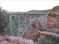 view gallery view gallerySW11.4 km |  Midgley, W. W., Bridge - Sedona, AZ Midgley, W. W., Bridge - Sedona, AZ
in U.S. National Register of Historic Places This is an arch bridge on US89A just north of Sedona, Arizona. The bridge spans Wilson Canyon where the canyon enters Oak Creek Canyon. posted by: adenium location: Arizona date approved: 05/29/2012 last visited: 09/02/2018 |
 view gallery view gallerySW11.4 km |  Midgley Bridge - Sedona, Arizona Midgley Bridge - Sedona, Arizona
in Arch Bridges This is an arch bridge on US89A just north of Sedona, Arizona. The bridge spans Wilson Canyon where the canyon enters Oak Creek Canyon. posted by: adenium location: Arizona date approved: 05/29/2012 last visited: 12/03/2010 |
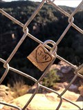 view gallery view gallerySW11.4 km |  Oak Canyon Overlook - Sedona, Arizona Oak Canyon Overlook - Sedona, Arizona
in Love Padlocks Located at the Oak Canyon Overlook along Midgely Bridge Trail. posted by: flyingmoose location: Arizona date approved: 12/16/2022 last visited: never |
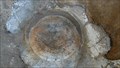
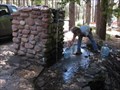 view gallery view galleryNW11.7 km |  Oak Creek Well, AZ Oak Creek Well, AZ
in Artesian Well This artesian well is located in Oak Creek Canyon in Arizona. posted by: Team Min Dawg location: Arizona date approved: 08/17/2009 last visited: 07/12/2010 |
 view gallery view galleryNW12.6 km | OAK in U.S. Benchmarks At south end of the Oak Creek Canyon Vista. posted by: macpurity location: Arizona date approved: 07/27/2010 last visited: 04/27/2023 |
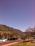
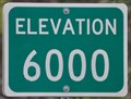 view gallery view galleryNW12.6 km |  Arizona Highway 89A ~ 6000 Foot Level Arizona Highway 89A ~ 6000 Foot Level
in Elevation Signs At this point you pass through the 6000 foot level on Arizona Highway 89A north of Sedona. posted by: brwhiz location: Arizona date approved: 06/22/2011 last visited: 09/05/2018 |
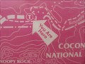 view gallery view gallerySW13.2 km | You Are Here Map - Sedona, AZ in 'You Are Here' Maps This map is located at the trailhead to Snoopy rock. posted by: bluesnote location: Arizona date approved: 04/13/2011 last visited: 04/13/2011 |
|