 view gallery view gallery N1.9 km N1.9 km
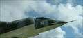
|   AV-8A Harrier, Havelock, North Carolina AV-8A Harrier, Havelock, North Carolina
in Static Aircraft Displays This static aircraft display in Havelock, North Carolina has actually become the city seal. Marine Corps Air Station, Cherry Point is located in Havelock. posted by:  showbizkid showbizkid location: North Carolina date approved: 07/02/2006 last visited: 01/01/2013 |
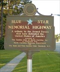 view gallery view galleryN2.1 km |  U.S. Highway 70, Havelock, North Carolina U.S. Highway 70, Havelock, North Carolina
in Blue Star Memorial Highway Markers The Blue Star Memorial Marker in Havelock, North Carolina, home of the Marine Corps Naval Air Station, Cherry Point. posted by: showbizkid location: North Carolina date approved: 07/05/2006 last visited: 08/25/2013 |
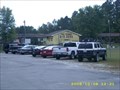
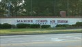 view gallery view galleryN2.6 km |  Marine Corps Air Station, Cherry Point Marine Corps Air Station, Cherry Point
in Military Installations Marine Corps Air Station, Cherry Point is the largest MCAS in the world. It is located in Havelock, North Carolina. More than 49,000 people make up the Cherry Point-related population, including active duty and retired Marines, the civilian workforce, and their dependents. posted by: showbizkid location: North Carolina date approved: 07/22/2006 last visited: 01/01/2013 |
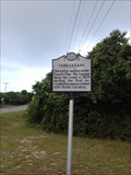
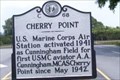 view gallery view galleryN2.6 km |  Cherry Point ---- C-68 Cherry Point ---- C-68
in North Carolina Historical Markers Located on NC 101 at Cunningham Blvd in Havelock NC posted by: Countrydragon location: North Carolina date approved: 01/14/2010 last visited: 01/01/2013 |
 view gallery view gallery W3.7 km W3.7 km
|  B&R Guns and Ranges - Havelock, NC B&R Guns and Ranges - Havelock, NC
in Shooting Ranges B&R is a popular Craven county shooting spot. They also have a fully stocked gun store where you can purchase firearms, ammo and accessories. posted by: oldtool53 location: North Carolina date approved: 10/09/2008 last visited: 11/09/2008 |
 view gallery view gallery NW4 km NW4 km
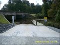
|  Slocum Creek boat ramp Havelock N.C. Slocum Creek boat ramp Havelock N.C.
in Boat Ramps Slocum Creek boat ramp is a popular launch site for fishing, kayaking and canoeing. Located in the city of Havelock near the Cherry Point Marine Corps Air Station. Slocum Creek leads to the Neuse River. The ramp is next to highway 70. posted by: oldtool53 location: North Carolina date approved: 10/08/2008 last visited: 11/09/2008 |
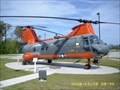 view gallery view galleryNW4.2 km | HH-46D Boeing Vertol Search and Rescue Helicopter in Static Aircraft Displays Displayed at the city of Havelock visitors center near the Cherry Point Marine Corps Air Station. posted by: oldtool53 location: North Carolina date approved: 10/16/2008 last visited: 05/13/2023 |
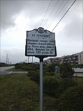
 view gallery view gallery SE9.2 km SE9.2 km
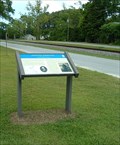
|  Newport Barracks-Winter Quarters Ablaze - Newport NC Newport Barracks-Winter Quarters Ablaze - Newport NC
in U.S. Civil War Sites On February 2, 1864 about 4 p.m. Gen. Martin's men, advancing along the county road and railroad, drove the Vermont troops back toward the barracks. The Federal artillery company prematurely abandoned the forts on both sides of the Newport River. posted by: Don.Morfe location: North Carolina date approved: 04/21/2023 last visited: 04/21/2023 |
 view gallery view gallerySE9.2 km |  Newport Barracks-Winter Quarters Ablaze - Newport NC Newport Barracks-Winter Quarters Ablaze - Newport NC
in Battlefields On February 2, 1864 about 4 p.m. Gen. Martin's men, advancing along the county road and railroad, drove the Vermont troops back toward the barracks. The Federal artillery company prematurely abandoned the forts on both sides of the Newport River. posted by: Don.Morfe location: North Carolina date approved: 04/21/2023 last visited: 04/21/2023 |
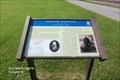
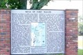
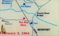 view gallery view gallerySE9.2 km |  You Are Here Maps - Newport Barracks-Winter Quarters Ablaze - Newport NC You Are Here Maps - Newport Barracks-Winter Quarters Ablaze - Newport NC
in 'You Are Here' Maps The You Are Here map shows that you are on Main Street, Newport NC posted by: Don.Morfe location: North Carolina date approved: 04/20/2023 last visited: 04/21/2023 |
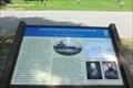
 view gallery view gallerySE9.2 km | Newport Barracks, Newport, North Carolina in Civil War Discovery Trail Sites Newport Barracks were originally built by Confederates in 1861, then captured and greatly improved by Union troops in 1862. The barracks were lost briefly to Confederates in 1864, but then returned to Union hands. posted by: showbizkid location: North Carolina date approved: 07/27/2006 last visited: 04/21/2023 |
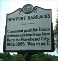 view gallery view gallerySE10 km | Newport Barracks, Marker C-57 in North Carolina Historical Markers A historic marker near the town of Newport notes the nearby location of the site of fortified barracks built by Confederates troops, and occupied sooner after by Union troops following the capture of Fort Macon. posted by: showbizkid location: North Carolina date approved: 07/26/2006 last visited: 04/21/2023 |
 view gallery view gallery NE12.1 km NE12.1 km
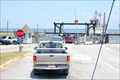
|  Cherry Branch-Minnesott Beach, Nr. Cherry Point, NC Cherry Branch-Minnesott Beach, Nr. Cherry Point, NC
in Ferries and Ferry Landings NC ferry across the Neuse River. Southern terminal. posted by: garmin_geek location: North Carolina date approved: 01/28/2009 last visited: 01/01/2013 |
 view gallery view gallerySE15.1 km | Bogue Sound Blockhouse - Newport NC in U.S. Civil War Sites Confederate artillery opened fire on the blockhouse, covering Company A, 17th North Carolina Infantry, which was deployed as skirmishers to attack it. About 200 yards from the blockhouse, the Confederate skirmish line charged. posted by: Don.Morfe location: North Carolina date approved: 04/21/2023 last visited: 04/21/2023 |
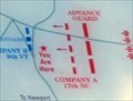 view gallery view gallerySE15.1 km | You Are Here maps - Bogue Sound Blockhouse - Newport NC in 'You Are Here' Maps The You Are Here map shows that you are at the intersection of McCabe Road and North Carolina Highway 24, Newport NC. and at the entrance of Gethsemane Memorial Park. posted by: Don.Morfe location: North Carolina date approved: 04/21/2023 last visited: 04/21/2023 |
 view gallery view gallerySE15.1 km | Bogue Sound Blockhouse - Newport NC in Battlefields Confederate artillery opened fire on the blockhouse, covering Company A, 17th North Carolina Infantry, which was deployed as skirmishers to attack it. About 200 yards from the blockhouse, the Confederate skirmish line charged. posted by: Don.Morfe location: North Carolina date approved: 04/21/2023 last visited: 04/21/2023 |
 view gallery view gallerySE15.1 km | Bogue Sound Blockhouse-Vermonters' Spirited Resistance - Newport NC in Civil War Discovery Trail Sites Company K, 9th New Jersey Volunteers, built the Bogue Sound Blockhouse here in the summer of 1862 to guard the junction of the Bogue Sound Road and Newport Road. posted by: Don.Morfe location: North Carolina date approved: 04/28/2020 last visited: 10/08/2021 |
 view gallery view gallerySE16.7 km |  Hooters Restaurant, Morehead City, NC Hooters Restaurant, Morehead City, NC
in Hooters Restaurants Hooters Restaurant on Route 70 in Morehead City, NC posted by: 79scouts location: North Carolina date approved: 08/01/2010 last visited: 04/09/2011 |
 view gallery view gallery E17.1 km E17.1 km
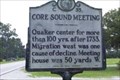
| Core Sound Meeting -- C-35 in North Carolina Historical Markers Located on NC-101, Harlowe, NC posted by: Countrydragon location: North Carolina date approved: 01/14/2010 last visited: 12/03/2003 |
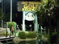 view gallery view gallery S19 km S19 km
|  Professor Hacker's Lost Treasure Golf & Raceway, Salter Path, NC Professor Hacker's Lost Treasure Golf & Raceway, Salter Path, NC
in Miniature Golf How about a ride on a mining train through caves, ancient ruins and under waterfalls to begin the adventure? posted by: garmin_geek location: North Carolina date approved: 02/03/2009 last visited: 07/11/2013 |
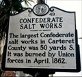 view gallery view gallerySE19.2 km | Confederate Salt Works --- C-49 in North Carolina Historical Markers Located on Arendell Street, Morehead City, NC posted by: Countrydragon location: North Carolina date approved: 01/14/2010 last visited: 04/20/2023 |
 view gallery view gallerySE19.2 km | SIEGE OF FORT MACON ---- CC-3 in North Carolina Historical Markers Located Arendell Street, Morehead City, NC posted by: Countrydragon location: North Carolina date approved: 01/18/2010 last visited: 04/20/2023 |
 view gallery view galleryS19.6 km | C-77 SS Pevensey in North Carolina Historical Markers C-77 SS Pevensey - Located on the Salter Path Road near Atlantic Beach, NC. posted by: david28377 location: North Carolina date approved: 07/28/2013 last visited: 07/28/2013 |
 view gallery view galleryS19.6 km | C-59 Verrazzano in North Carolina Historical Markers C-59 Verrazzano Located on the Salter Path Road near the intersection of Pine Knoll Blvd west of Atlantic Beach, NC. posted by: david28377 location: North Carolina date approved: 07/28/2013 last visited: 07/28/2013 |
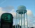 view gallery view gallerySE19.8 km |  Morehead City Municpal Water Tower Morehead City Municpal Water Tower
in Water Towers The municipal water tower in Morehead City, North Carolina. posted by: showbizkid location: North Carolina date approved: 06/29/2006 last visited: 07/13/2013 |
|