 view gallery view gallery N33 km N33 km
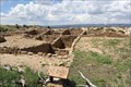
|   Atsinna Pueblo ruins -- El Morro National Monument, NM Atsinna Pueblo ruins -- El Morro National Monument, NM
in New World Ancient Evidence The ruins of the Atsinna Pueblo at El Morro National Monument are located on top of the mesa, and are accessible from the Mesa Loop Trail posted by:  Benchmark Blasterz Benchmark Blasterz location: New Mexico date approved: 08/25/2014 last visited: 01/18/2023 |
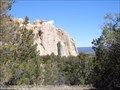 view gallery view galleryN33.2 km |  Inscription Rock and Mesa Top Trail Loop - El Morro National Monument Inscription Rock and Mesa Top Trail Loop - El Morro National Monument
in Scenic Hikes One trail passes by the base and the other climbs to the top of El Morro, a 200 foot high questa that dominates El Morro National Monument. posted by:  linkys linkys location: New Mexico date approved: 04/04/2008 last visited: 01/18/2023 |
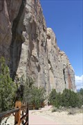 view gallery view galleryN33.2 km |  Inscription Rock -- El Morro National Monument, NM Inscription Rock -- El Morro National Monument, NM
in Graffiti For thousands of years, human beings ranging from Ancient Puebloans to Spanish conquistadors to pioneers to railroad crews have been scratching their names into Inscription Rock. posted by: Benchmark Blasterz location: New Mexico date approved: 08/22/2014 last visited: 01/18/2023 |
 view gallery view galleryN33.2 km |  El Morro National Monument - Ramah NM El Morro National Monument - Ramah NM
in Wikipedia Entries El Morro National Monument is a U.S. national monument in Cibola County, New Mexico. The monument preserves the remains of a large prehistoric pueblo atop a great sandstone promontory with a pool of water at its base. posted by: Don.Morfe location: New Mexico date approved: 01/19/2023 last visited: 01/18/2023 |
 view gallery view galleryN33.2 km |  El Morro National Monument - El Morro NM El Morro National Monument - El Morro NM
in U.S. National Register of Historic Places El Morro National Monument is a U.S. national monument. The monument preserves the remains of a large prehistoric pueblo atop a great sandstone promontory with a pool of water at its base. posted by: Don.Morfe location: New Mexico date approved: 01/21/2023 last visited: 01/18/2023 |
 view gallery view galleryN33.2 km | ") El Morro National Monument - Ramah NM El Morro National Monument - Ramah NM
in National Parks (U.S.) El Morro National Monument is a U.S. national monument in Cibola County, New Mexico. The monument preserves the remains of a large prehistoric pueblo atop a great sandstone promontory with a pool of water at its base. posted by: Don.Morfe location: New Mexico date approved: 01/18/2023 last visited: 01/18/2023 |
 view gallery view galleryN33.2 km |  El Morro National Monument - Ramah NM El Morro National Monument - Ramah NM
in National Parks of the World El Morro National Monument is a U.S. national monument in Cibola County, New Mexico. The monument preserves the remains of a large prehistoric pueblo atop a great sandstone promontory with a pool of water at its base. posted by: Don.Morfe location: New Mexico date approved: 01/18/2023 last visited: 01/18/2023 |
 view gallery view galleryN33.2 km |  El Morro National Monument - Ramah NM El Morro National Monument - Ramah NM
in Official Local Tourism Attractions Ancestral Puebloans, Spanish and American travelers carved over 2,000 signatures, dates, messages, and petroglyphs. We invite you to make El Morro a stopping point on your travels. posted by: Don.Morfe location: New Mexico date approved: 01/19/2023 last visited: 01/18/2023 |
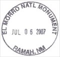
 view gallery view galleryN33.2 km |  Ranger Station at El Morro National Monument - Ramah NM Ranger Station at El Morro National Monument - Ramah NM
in Ranger Stations The Ranger Station is located at the Visitor Center in El Morro National Monument. Here one may obtain a NPS Cancellation Stamp. posted by: Don.Morfe location: New Mexico date approved: 01/18/2023 last visited: 01/18/2023 |
 view gallery view galleryN33.2 km |  El Morro National Monument - Ramah NM El Morro National Monument - Ramah NM
in Satellite Imagery Oddities Ancestral Puebloans, Spanish and American travelers carved over 2,000 signatures, dates, messages, and petroglyphs. We invite you to make El Morro a stopping point on your travels. posted by: Don.Morfe location: New Mexico date approved: 01/18/2023 last visited: 01/18/2023 |
 view gallery view galleryN33.2 km |  El Morro National Monument El Morro National Monument
in NPS Passport Cancellation Stations There is a Passport Cancellation Station in the information center, look near the information desk/cash register. posted by: KC0GRN location: New Mexico date approved: 08/22/2005 last visited: 01/18/2023 |
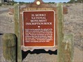 view gallery view galleryN34 km |  El Morro National Monument Inscription Rock El Morro National Monument Inscription Rock
in New Mexico Historical Markers A watering hole and sandstone bluff where travelers carved their symbols and names for century's, and that is now part of a National Monument. posted by: linkys location: New Mexico date approved: 12/17/2009 last visited: 08/19/2019 |
 view gallery view galleryN42 km |  Zuni Reservation - New Mexico Zuni Reservation - New Mexico
in Nations Within Nations A traditional Pueblo People with a unique language, culture, and history that is famous for its inlayed silver jewelry, stone fetishes and pottery. posted by: linkys location: New Mexico date approved: 03/31/2008 last visited: 07/29/2014 |
 view gallery view galleryN42.6 km |  Ramah Water Tower - Ramah, New Mexico Ramah Water Tower - Ramah, New Mexico
in Water Towers Small water tower in a small New Mexico town. posted by: linkys location: New Mexico date approved: 03/31/2008 last visited: 07/28/2014 |
 view gallery view gallery NE42.6 km NE42.6 km
|  Bandera Ice Cave Benchmark Bandera Ice Cave Benchmark
in U.S. Benchmarks This benchmark is located in the Bandera Ice Cave. posted by: urbaneasy & easier location: New Mexico date approved: 09/03/2008 last visited: 07/29/2014 |
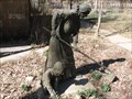 view gallery view galleryN42.8 km |  The Pioneer Gardener - Ramah, New Mexico The Pioneer Gardener - Ramah, New Mexico
in Figurative Public Sculpture Bronze life size sculpture a woman and child gardening. posted by: linkys location: New Mexico date approved: 04/01/2008 last visited: 05/10/2012 |
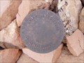 view gallery view galleryN42.8 km | Cadastral Disk in Ramah, NM in U.S. Benchmarks Bureau of Land Management Cadastral Survey Disc on an exercise trail in the community of Ramah, New Mexico, USA posted by: Hawikuh location: New Mexico date approved: 07/23/2009 last visited: never |
 view gallery view galleryNE43 km |  The Land of Fire & Ice The Land of Fire & Ice
in Mom and Pop Rock Shops The Historic Trading Post here has ancient artifacts on display. Most of these were found in the lava and some date back 1,200 years! posted by: Colombian Princess location: New Mexico date approved: 07/17/2008 last visited: 07/29/2014 |
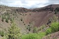 view gallery view galleryNE43 km |  Bandera Crater - nr Candelaria Trading Post, NM Bandera Crater - nr Candelaria Trading Post, NM
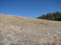
in Volcano Watching The waymark coordinates are for the viewing overlook for the center of this long-dormant volcano at the Bandera Volcano and Ice Cave attraction on N 53, part of the Zuni-Bandera lava field. posted by: Benchmark Blasterz location: New Mexico date approved: 08/22/2014 last visited: 08/19/2019 |
 view gallery view galleryNE43.1 km | Bandera Ice cave & Crater -- nr Candelaria Trading Post NM in Official Local Tourism Attractions The amazing Bandera Ice Cave and Bandera Crater are well worth a stop when travelling in this part of northern NM posted by: Benchmark Blasterz location: New Mexico date approved: 08/23/2014 last visited: 08/23/2014 |
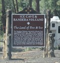 view gallery view galleryNE43.1 km | Ice Cave & Bandera Volcano - nr Bandera Volcano NM in New Mexico Historical Markers The historic marker outside of the Bandera Volcano and Ice Cave visitor center posted by: Benchmark Blasterz location: New Mexico date approved: 08/22/2014 last visited: 08/19/2019 |
 view gallery view galleryNE43.1 km |  Bandera Ice Cave and Crater -- nr Candelaria Trading Post NM Bandera Ice Cave and Crater -- nr Candelaria Trading Post NM
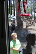
in Birdwatching Locations One of the best places to see hummingbirds is right outside of the Bandera Ice Cave visitor center posted by: Benchmark Blasterz location: New Mexico date approved: 08/26/2014 last visited: 08/27/2014 |
 view gallery view galleryN43.8 km |  Ramah Lake Dam - Ramah, New Mexico Ramah Lake Dam - Ramah, New Mexico
in Water Dams What started as an irrigation dike in the late 1890's is now an earthen dam on the Zuni River. posted by: linkys location: New Mexico date approved: 04/01/2008 last visited: never |
 view gallery view galleryNE43.8 km |  Continental Divide - 7882' - Cibola County, NM Continental Divide - 7882' - Cibola County, NM
in Elevation Signs Continental Divide sign on Hwy 53 in Cibola National Forest. posted by: linkys location: New Mexico date approved: 11/14/2009 last visited: 08/19/2019 |
 view gallery view gallery S45.7 km S45.7 km
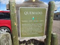
| Quemado NM 6,890 ft in Elevation Signs This Elevation Sign is on US Hwy 60 on the west side of Quemado, New Mexico. posted by: PeterNoG location: New Mexico date approved: 03/16/2018 last visited: 08/18/2020 |
|