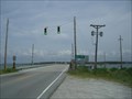
 view gallery view gallery W3.5 km W3.5 km
|   Earl C. Davis Memorial Bridge Earl C. Davis Memorial Bridge
in Moving Bridges Drawbridge across The Straits on SR 1335, at Beaufort, Carteret County, NC. posted by:  fatcat161 fatcat161 location: North Carolina date approved: 05/06/2009 last visited: never |
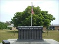 view gallery view gallery S3.7 km S3.7 km
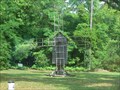
|  Veterans Memorial in Harkers Island, NC Veterans Memorial in Harkers Island, NC
in Non-Specific Veteran Memorials Located on Harkers Island Rd. posted by: fatcat161 location: North Carolina date approved: 05/11/2009 last visited: never |
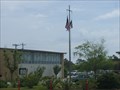 view gallery view galleryS3.7 km |  Harkers Island Elementary School - Harkers Island, NC Harkers Island Elementary School - Harkers Island, NC
in Nautical Flag Poles Located in front of Harkers Island Elementary School on Island Rd. posted by: fatcat161 location: North Carolina date approved: 10/13/2009 last visited: never |
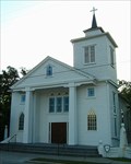
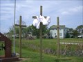 view gallery view galleryS3.9 km |  Huggins Memorial Baptist Church Crosses Huggins Memorial Baptist Church Crosses
in Churchyard Crosses Three wooden crosses located beside the church. posted by: fatcat161 location: North Carolina date approved: 05/06/2009 last visited: never |
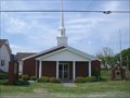 view gallery view galleryS3.9 km |  Huggins Memorial Baptist Church - Harkers Island, NC Huggins Memorial Baptist Church - Harkers Island, NC
in Baptist Churches Small Baptist church in Harkers Island, NC. posted by: fatcat161 location: North Carolina date approved: 05/06/2009 last visited: never |
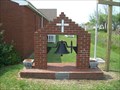 view gallery view galleryS3.9 km |  Huggins Memorial Baptist Church Bell Huggins Memorial Baptist Church Bell
in Bells Bell located at Huggins Memorial Baptist Church in Harkers Island, NC. posted by: fatcat161 location: North Carolina date approved: 05/06/2009 last visited: never |
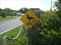 view gallery view galleryS4.3 km |  Duck Crossing in Harkers Island, NC Duck Crossing in Harkers Island, NC
in Uncommon Crossing Signs Located at about 1695 Island Rd, Harkers Island, NC 28531 posted by: fatcat161 location: North Carolina date approved: 05/06/2009 last visited: never |
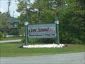 view gallery view galleryS4.5 km |  Core Sound Waterfowl Museum and Heritage Center Core Sound Waterfowl Museum and Heritage Center
in Nature Centers Located on Calico Cloister Rd just off of Island rd in Harkers Island, NC. posted by: fatcat161 location: North Carolina date approved: 05/06/2009 last visited: 10/24/2015 |
 view gallery view galleryS4.5 km |  Core Sound Waterfowl Museum Windmill Core Sound Waterfowl Museum Windmill
in Windmills Windmill located at Core Sound Waterfowl Museum. posted by: fatcat161 location: North Carolina date approved: 05/07/2009 last visited: 08/10/2010 |
 view gallery view galleryS4.7 km |  Olive Thurlow - Cape Lookout NC Olive Thurlow - Cape Lookout NC
in Shipwrecks The Olive Thurlow met its fate here in December 1902. posted by: ECPirates location: North Carolina date approved: 11/10/2008 last visited: 12/08/2022 |
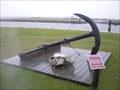 view gallery view galleryS4.7 km |  Olive Thurlow Anchor - Cape Lookout NC Olive Thurlow Anchor - Cape Lookout NC
in Anchors The anchor of the Olive Thurlow. posted by: ECPirates location: North Carolina date approved: 10/17/2008 last visited: 12/08/2022 |
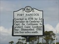 view gallery view galleryS4.7 km |  Fort Hancock - C55 Fort Hancock - C55
in North Carolina Historical Markers Located on Harkers Island Rd at the tip of Harkers Island. posted by: fatcat161 location: North Carolina date approved: 05/05/2009 last visited: 10/27/2015 |
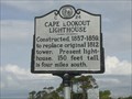 view gallery view galleryS4.8 km | Cape Lookout Lighthouse - C24 in North Carolina Historical Markers Located on Harkers Island Rd at the tip of Harkers Island. posted by: fatcat161 location: North Carolina date approved: 05/05/2009 last visited: 12/08/2022 |
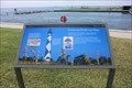 view gallery view galleryS4.8 km |  Protecting People and Ships - Harkers Island NC Protecting People and Ships - Harkers Island NC
in Signs of History The 1859 Cape Lookout Lighthouse warns ships about the dangerous Cape Lookout Shoals—sandbars that jut out over 10 miles into the ocean. posted by: Don.Morfe location: North Carolina date approved: 12/08/2022 last visited: 12/09/2022 |
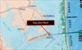 view gallery view galleryS4.8 km |  You Are Here-Cape Lookout National Seashore - Harkers Island NC You Are Here-Cape Lookout National Seashore - Harkers Island NC
in 'You Are Here' Maps The YOU ARE HERE map is on the Be Prepared marker indicating you are at the Visitor Center at Cape Lookout National Seashore. posted by: Don.Morfe location: North Carolina date approved: 12/08/2022 last visited: 12/09/2022 |
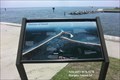
 view gallery view galleryS4.8 km | You Are Here-Cape Lookout National Seashore - Harkers Island NC in 'You Are Here' Maps The YOU ARE HERE map is on a Horizon of Islands marker indicating you are on Shell Point at Cape Lookout National Seashore. posted by: Don.Morfe location: North Carolina date approved: 12/08/2022 last visited: 12/09/2022 |
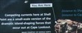
 view gallery view galleryS4.8 km | Horizon of Islands - Harkers Island NC in Signs of History Out on those barrier islands you quickly discover the park’s land is but a thin edge, much of it less than a few hundred yards wide. posted by: Don.Morfe location: North Carolina date approved: 12/08/2022 last visited: 12/09/2022 |
 view gallery view gallery NE7.2 km NE7.2 km
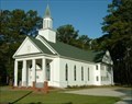
|  Williston United Methodist Church, Williston, North Carolina Williston United Methodist Church, Williston, North Carolina
in Country Churches Springfield Methodist Episcopal Church was built in 1883. The church is now called Williston United Methodist Church. It is located in the "Down East" community of Williston. posted by: showbizkid location: North Carolina date approved: 07/22/2006 last visited: 06/25/2006 |
 view gallery view galleryNE7.2 km | Williston United Methodist Church, formerly Springfield Methodist Episcopal Church, Williston, North Carolina in This Old Church Williston United Methodist Church was orginally called Springfield Methodist Episcopal Church, South and was built in 1883. posted by: showbizkid location: North Carolina date approved: 07/22/2006 last visited: 06/24/2006 |
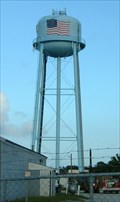 view gallery view galleryW10.3 km |  Municipal Water Tower, Beaufort, North Carolina Municipal Water Tower, Beaufort, North Carolina
in Water Towers The municipal water tower in Beaufort. posted by: showbizkid location: North Carolina date approved: 07/21/2006 last visited: 10/16/2012 |
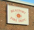 view gallery view galleryW10.6 km |  Beaufort Fire Department, Beaufort, North Carolina Beaufort Fire Department, Beaufort, North Carolina
in Firehouses The Fire Station in Beaufort, North Carolina. posted by: showbizkid location: North Carolina date approved: 07/21/2006 last visited: 10/16/2012 |
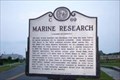 view gallery view galleryW10.9 km | MARINE RESEARCH --- C-69 in North Carolina Historical Markers Located on Front St. at Live Oak St in Beaufort NC posted by: Countrydragon location: North Carolina date approved: 01/18/2010 last visited: 06/11/2016 |
 view gallery view galleryW11.1 km | Purvis Chapel, Beaufort, North Carolina in This Old Church Purvis Chapel is the oldest church in continuous use in Beaufort. This church was originally built as a Methodist church and later given to the AME Zion congregation. This church is one of three in Beaufort that border on the Old Burying Ground cemetery. posted by: showbizkid location: North Carolina date approved: 07/26/2006 last visited: 10/16/2012 |
 view gallery view galleryW11.1 km |  Carteret County Confederate Monument, Beaufort, North Carolina Carteret County Confederate Monument, Beaufort, North Carolina
in American Civil War Monuments and Memorials The Civil War Monument for Carteret County is on the grounds of the courthouse in Beaufort. posted by: showbizkid location: North Carolina date approved: 07/02/2006 last visited: 04/10/2023 |
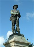
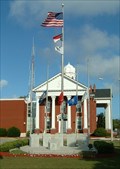 view gallery view galleryW11.1 km |  Carteret County Veterans Memorial, Beaufort, North Carolina Carteret County Veterans Memorial, Beaufort, North Carolina
in World War I Memorials and Monuments The Carteret County Veterans Memorial honors veterans from World War I forward. posted by: showbizkid location: North Carolina date approved: 07/28/2006 last visited: 10/16/2012 |
|