 view gallery view gallery S0.2 km S0.2 km
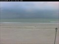
|   Atlantic Beach, North Carolina Webcam Atlantic Beach, North Carolina Webcam
in Web Cameras Surf cam at Atlantic Beach, North Carolina posted by:  showbizkid showbizkid location: North Carolina date approved: 01/06/2006 last visited: 08/27/2011 |
 view gallery view gallery W1 km W1 km
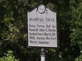
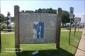
|  Hoophole Creek - C 62 Hoophole Creek - C 62
in North Carolina Historical Markers Historical Marker in Atlantic Beach, North Carolina. posted by: 79scouts location: North Carolina date approved: 07/29/2010 last visited: 07/28/2013 |
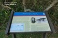 view gallery view galleryW1.1 km |  Hoop Pole Creek Ferrying Troops and Equipment at High Tide - Atlantic Beach NC Hoop Pole Creek Ferrying Troops and Equipment at High Tide - Atlantic Beach NC
in U.S. Civil War Sites On March 29, a detachment of the 4th Rhode Island Infantry crossed Bogue Sound from Carolina City and established an outpost camp on Bogue Banks here at Hoop Pole Creek, five miles from Fort Macon. posted by: Don.Morfe location: North Carolina date approved: 04/08/2023 last visited: 04/08/2023 |
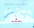 view gallery view galleryW1.1 km |  You Are Here Map - Hoop Pole Creek Ferrying Troops and Equipment at High Tide - Atlantic Beach NC You Are Here Map - Hoop Pole Creek Ferrying Troops and Equipment at High Tide - Atlantic Beach NC
in 'You Are Here' Maps The You Are Here Map shows that you are at Atlantic Station Shopping Center parking lot at 916 W Fort Macon Rd, Atlantic Beach NC 28512 posted by: Don.Morfe location: North Carolina date approved: 04/08/2023 last visited: 04/08/2023 |
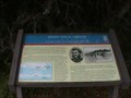 view gallery view galleryW1.1 km | North Carolina Civil War Trail - Hoop Pole Creek in Civil War Discovery Trail Sites Union forces led by General John G. Parke landed at Hoop Pole Creek March 29, 1862, during the Fort Macon campaign. posted by: 79scouts location: North Carolina date approved: 07/28/2010 last visited: 04/08/2023 |
 view gallery view gallery N2.7 km N2.7 km
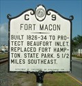
| Fort Macon, Marker C-9 in North Carolina Historical Markers Built in 1826-1834 on the east end of Bogue Banks in Carteret County, Fort Macon replaced Fort Dobbs, a wooden structure built in 1756 and Fort Hampton, a similar structure which eventually washed away. Fort Macon is about 5 1/2 miles from this marker in Atlantic Beach. posted by: showbizkid location: North Carolina date approved: 07/01/2006 last visited: 12/02/2003 |
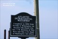 view gallery view galleryN2.7 km | Atlantic Intracoastal Waterway in North Carolina Historical Markers Completed in 1932 from Norfolk to Wilmington via Beaufort-Morehead City. Sen. F.M. Simmons of New Bern and Rep. J.H. Small of Washington led effort. posted by: Don.Morfe location: North Carolina date approved: 03/26/2020 last visited: 10/23/2021 |
 view gallery view galleryN2.7 km |  Morehead City Boating Access Area - NC Morehead City Boating Access Area - NC
in Boat Ramps Boat ramp at 3407 Arendell St, Morehead City. posted by: 79scouts location: North Carolina date approved: 07/29/2010 last visited: 07/23/2014 |
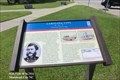
 view gallery view galleryN2.9 km |  Carolina City-A Favorite Resort Stop - Morehead City Carolina City-A Favorite Resort Stop - Morehead City
in Battlefields A Confederate detachment from the fort burned anything that would be useful to the Federals, including the turpentine works, the winter quarters at Camp Vance, and the Carolina Hotel, the town wharf, where barges transported them across the sound. posted by: Don.Morfe location: North Carolina date approved: 04/21/2023 last visited: 04/20/2023 |
 view gallery view galleryN2.9 km | Siege of Fort Macon - Morehead City NC in Battlefields Contact: On April 8 contact was established between the opposing forces. The Confederates were driven (G) into the fort after several days of heavy skirmishing. Fort Macon was now completely invested by the Union forces. posted by: Don.Morfe location: North Carolina date approved: 04/21/2023 last visited: 04/20/2023 |
 view gallery view galleryN2.9 km | Carolina City-A Favorite Resort Stop - Morehead City in U.S. Civil War Sites The war left Carolina City, described as "containing fifty to one hundred inhabitants, a few respectable dwellings and the ruins of a large hotel," devastated and financially ruined. It was eventually absorbed into Morehead City. posted by: Don.Morfe location: North Carolina date approved: 04/21/2023 last visited: 04/20/2023 |
 view gallery view galleryN2.9 km | North Carolina Civil War Trail - Carolina City in Civil War Discovery Trail Sites North Carolina Civil War Trail Marker, Carolina City located at the Crystal Coast Welcome Center in Morehead City. posted by: 79scouts location: North Carolina date approved: 07/28/2010 last visited: 04/20/2023 |
 view gallery view galleryN2.9 km |  Caratet County Rest Area / Visitor Center - US Route 70 - Morehead City, NC Caratet County Rest Area / Visitor Center - US Route 70 - Morehead City, NC
in Highway Rest Areas The Caratet County Rest Area / Visitor Center is located on US Route 70, in Morehead City, Caratet County, NC posted by: outdoorboy34 location: North Carolina date approved: 01/27/2017 last visited: 04/20/2023 |
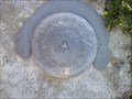 view gallery view galleryN3.1 km |  DP1441(NCRR CA E91 4) - Morehead City NC DP1441(NCRR CA E91 4) - Morehead City NC
in U.S. Benchmarks This is a Concord Engineering & Survey survey disk in Morehead City, Carteret County. posted by: shorbird location: North Carolina date approved: 05/06/2014 last visited: 04/18/2015 |
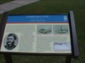
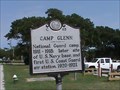 view gallery view galleryN3.1 km | Camp Glenn - C 63 in North Carolina Historical Markers North Carolina Historical Marker - Camp Glenn - C 63 posted by: 79scouts location: North Carolina date approved: 07/29/2010 last visited: 04/18/2015 |
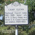 view gallery view galleryN3.1 km |  FIRST - U.S. Coast Guard Air Station-Camp Glenn - Morehead City NC FIRST - U.S. Coast Guard Air Station-Camp Glenn - Morehead City NC
in First of its Kind Camp Glenn site of U.S. Navy base and first U.S. Coast Guard air station 1920-1921. posted by: Don.Morfe location: North Carolina date approved: 10/21/2022 last visited: 10/22/2022 |
 view gallery view gallery NW3.1 km NW3.1 km
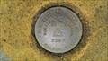
| DK7224 (BETTY) - Morehead City, NC in U.S. Benchmarks A benchmark in the sidewalk in front of the Division of Marine Fisheries in Morehead City, NC. posted by:  DukeRoom DukeRoom location: North Carolina date approved: 09/06/2013 last visited: 04/18/2015 |
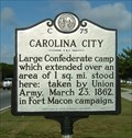
 view gallery view galleryNW3.1 km | Carolina City - Morehead City NC in Battlefields Large Confederate camp in Carolina City was taken by Union Army on March 23, 1862. posted by: Don.Morfe location: North Carolina date approved: 04/21/2023 last visited: 04/20/2023 |
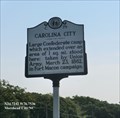
 view gallery view galleryNW3.1 km | Carolina City, Marker C-75 in North Carolina Historical Markers Carolina City was a large Confederate camp until Union Troops captured the area in March 1862. This marker is on U.S. Hwy 70 on Morehead City. posted by: showbizkid location: North Carolina date approved: 07/26/2006 last visited: 04/20/2023 |
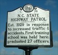 view gallery view galleryNW3.1 km | North Carolina State Highway Patrol, Marker C-76 in North Carolina Historical Markers In response to a substantial increase in motor vehicles and motor vehicle accidents and deaths, the state established the North Carolina State Highway Patrol. The first 10 patrolmen candidates attended school in Pennsylvania, but future troopers would be trained at a new facility at Camp Glenn near Morehead City. posted by: showbizkid location: North Carolina date approved: 07/26/2006 last visited: 07/22/2014 |
 view gallery view gallery E3.1 km E3.1 km
|  A Place at the Beach III - 8 MPH A Place at the Beach III - 8 MPH
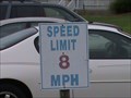
in Unusual Speed Limits 8 MPH is the speed limit in the Place at the Beach III timeshare / condo complex in Atlantic Beach, NC. posted by: 79scouts location: North Carolina date approved: 07/28/2010 last visited: never |
 view gallery view gallery NE3.4 km NE3.4 km
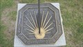
|  Kirk DePriter Memorial Sundial - Morehead City, NC Kirk DePriter Memorial Sundial - Morehead City, NC
in Sundials This sundial is located at the waterfront in Morehead City, NC. It is a memorial to Kirk DePriter. posted by: 79scouts location: North Carolina date approved: 07/27/2011 last visited: 10/16/2012 |
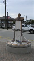
 view gallery view galleryNE3.4 km |  The Carolina Sounder, Morehead City, NC The Carolina Sounder, Morehead City, NC
in Maritime Monuments and Memorials A maritime memorial located at the waterfront in Morhead City, NC. posted by: 79scouts location: North Carolina date approved: 07/27/2011 last visited: 10/16/2012 |
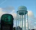 view gallery view galleryNW3.5 km |  Morehead City Municpal Water Tower Morehead City Municpal Water Tower
in Water Towers The municipal water tower in Morehead City, North Carolina. posted by: showbizkid location: North Carolina date approved: 06/29/2006 last visited: 07/13/2013 |
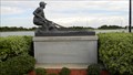
 view gallery view galleryNE3.5 km | North Carolina Waterman Memorial - Morehead City, NC in Maritime Monuments and Memorials A sea related memorial located at the docks in Morehead City. posted by: 79scouts location: North Carolina date approved: 07/27/2011 last visited: 10/16/2012 |
|