 view gallery view gallery SE4.2 km SE4.2 km
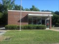
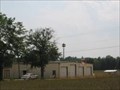
|   Enoree, SC - 29335 Enoree, SC - 29335
in U.S. Post Offices Small town South Carolina :-) posted by:  bluesneaky bluesneaky location: South Carolina date approved: 06/26/2012 last visited: never |
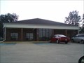
 view gallery view gallery W5.1 km W5.1 km
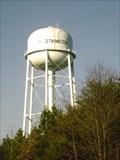
|  Westminster Water Tower Westminster Water Tower
in Water Towers Westminster Water Tower posted by: waypointazoid location: South Carolina date approved: 01/09/2007 last visited: 05/15/2018 |
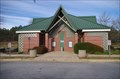
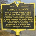 view gallery view galleryW7.2 km |  Youngs School Youngs School
in South Carolina Historical Markers This Historical Marker is located in Young's Community between Gray Court and Woodruff South Carolina. posted by: laurenscitylimits location: South Carolina date approved: 12/13/2007 last visited: never |
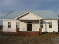 view gallery view galleryW7.2 km |  Youngs School - Gray Court, South Carolina, USA Youngs School - Gray Court, South Carolina, USA
in Former Schools Young's School located between Gray Court and Woodruff South Carolina. posted by: laurenscitylimits location: South Carolina date approved: 12/14/2007 last visited: never |
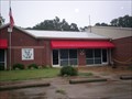
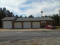
 view gallery view galleryW7.2 km |  Young's Fire Department Young's Fire Department
in Firehouses Located on Harris Bridge Road in Woodruff, SC posted by:  Firefrog69 Firefrog69 location: South Carolina date approved: 12/02/2008 last visited: never |
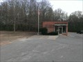
 view gallery view gallery NW9.5 km NW9.5 km
| Woodruff, SC 29388 in U.S. Post Offices The main and only Post Office in Woodruff, SC. posted by: papermanone & catlover location: South Carolina date approved: 08/03/2008 last visited: never |
 view gallery view gallery E12.4 km E12.4 km
| Cross Anchor, SC - 29331 in U.S. Post Offices Small post office in Cross Anchor, SC posted by: gpsblake location: South Carolina date approved: 03/03/2015 last visited: 01/14/2016 |
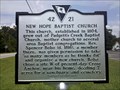 view gallery view galleryE12.4 km | New Hope Baptist Church in South Carolina Historical Markers This marker is located near the intersection of Highway 56 and Burnt Factory Road. The marker was recently installed in 2010. posted by: Hawaiian Ninja location: South Carolina date approved: 09/01/2010 last visited: 12/12/2015 |
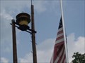
 view gallery view galleryE12.6 km | Cross Anchor Fire Department in Firehouses Located in Cross Anchor,South Carolina. posted by: Firefrog69 location: South Carolina date approved: 10/04/2009 last visited: 01/14/2016 |
 view gallery view galleryE12.6 km |  Cross Anchor, SC Siren Cross Anchor, SC Siren
in Outdoor Warning Sirens This siren is mounted at the Cross Anchor Fire Department. posted by: papermanone & catlover location: South Carolina date approved: 08/01/2008 last visited: 01/14/2016 |
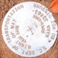
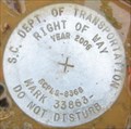 view gallery view galleryW12.9 km |  SCDOT ROW FCR002 SCDOT ROW FCR002
in U.S. Benchmarks SCDOT ROW Marker Owings South Carolina posted by: OXCACHER location: South Carolina date approved: 01/07/2007 last visited: never |
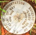
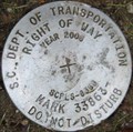 view gallery view galleryW12.9 km | SCDOT ROW FCR001 in U.S. Benchmarks SCDOT ROW Marker Owings South Carolina posted by: OXCACHER location: South Carolina date approved: 01/07/2007 last visited: never |
 view gallery view galleryW12.9 km | SCDOT ROW FCR004 in U.S. Benchmarks SCDOT ROW Marker Owings South Carolina posted by: OXCACHER location: South Carolina date approved: 01/14/2007 last visited: never |
 view gallery view galleryW12.9 km | SCDOT ROW FCR005 in U.S. Benchmarks SCDOT ROW Marker Owings South Carolina posted by: OXCACHER location: South Carolina date approved: 01/14/2007 last visited: never |
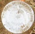 view gallery view galleryW12.9 km | SCDOT ROW FCR003 in U.S. Benchmarks SCDOT ROW Marker Owings South Carolina posted by: OXCACHER location: South Carolina date approved: 01/14/2007 last visited: never |
 view gallery view gallery S13.4 km S13.4 km
| Sandy Springs Fire Dept. in Firehouses A small rural volunteer station located in Laurens County,SC. posted by: Firefrog69 location: South Carolina date approved: 02/20/2011 last visited: never |
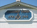 view gallery view gallery SW14.6 km SW14.6 km
|  Schroder Lodge 144 Gray Court, SC Schroder Lodge 144 Gray Court, SC
in Masonic Temples Schroder Lodge 144 Gray Court, SC posted by: RonMiller location: South Carolina date approved: 04/07/2009 last visited: never |
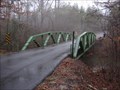 view gallery view gallerySE15.1 km |  Musgrove Mill Bridge Musgrove Mill Bridge
in Truss Bridges This Truss Bridge is located near the Musgrove Mill State Park in Union County, South Carolina posted by: OXCACHER location: South Carolina date approved: 12/31/2006 last visited: 06/07/2018 |
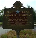 view gallery view galleryS15.4 km |  Interstate 385 Rest Area, Laurens, SC. Interstate 385 Rest Area, Laurens, SC.
in Blue Star Memorial Highway Markers Blue Star Memorial Highway marker at the rest area on Interstate 385, mile marker 6. posted by: BIO-HAZRD location: South Carolina date approved: 07/07/2012 last visited: 04/06/2016 |
 view gallery view galleryS15.6 km |  I-385 NB/SB Rest Area - Laurens, SC. I-385 NB/SB Rest Area - Laurens, SC.
in Highway Rest Areas A rest area located between the North and South bound lanes of Interstate 385. posted by: BIO-HAZRD location: South Carolina date approved: 01/11/2016 last visited: 04/06/2016 |
 view gallery view gallerySE15.8 km |  The Battle of Musgrove's Mill Memorial Bridge - 1999 - Clinton, SC. The Battle of Musgrove's Mill Memorial Bridge - 1999 - Clinton, SC.
in Bridge Date Stones and Plaques This Bridge crosses over the Enoree River and was refurbished in 1999. posted by: BIO-HAZRD location: South Carolina date approved: 02/17/2016 last visited: 06/07/2018 |
 view gallery view gallerySE15.9 km |  Battle of Musgrove Mill - Clinton, SC. Battle of Musgrove Mill - Clinton, SC.
in Battlefields This Marker is located on the side of Hwy 56 at the south end of the bridge over the Enoree River. posted by: BIO-HAZRD location: South Carolina date approved: 02/23/2016 last visited: 06/07/2018 |
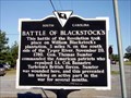 view gallery view galleryE15.9 km | Battle of Blackstock’s in South Carolina Historical Markers The marker is located on the northwest corner of SC49 (Union/Cross Keys Highway) and Blackstock Road. There is no parking. I used a driveway to get off the road. There is a battlefield monument that is north on Blackstock and east on Monument Road. posted by: S5280ft location: South Carolina date approved: 04/15/2007 last visited: 06/01/2012 |
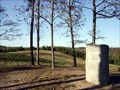 view gallery view galleryE15.9 km | Battle of Blackstock’s in Battlefields The historical marker is located on the northwest corner of SC49 (Union/Cross Keys Highway) and Blackstock Road. There is no parking except a driveway. The battlefield monument that is north on Blackstock and east on Monument Road. Parking available. posted by: S5280ft location: South Carolina date approved: 05/06/2007 last visited: 06/01/2012 |
 view gallery view gallery N17.1 km N17.1 km
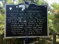
| Site of Fredonia in South Carolina Historical Markers This marker is located right along the road and can be hard to see if you are driving too fast. If you do visit this marker, please be careful and pull off the road completely onto the shoulder. posted by: Hawaiian Ninja location: South Carolina date approved: 10/04/2010 last visited: 05/03/2014 |
|