 view gallery view gallery N8.2 km N8.2 km
|   Lake Hughes ~ Population 500 Lake Hughes ~ Population 500
in Population Signs This combination Elevation/Population sign is on the north side of Elizabeth Lake Road at the eastern town limits of Lake Hughes, California. posted by:  brwhiz brwhiz location: California date approved: 08/25/2013 last visited: never |
 view gallery view galleryN8.2 km |  Lake Hughes ~ Elevation 3250 Lake Hughes ~ Elevation 3250
in Elevation Signs This combination Elevation/Population sign is on the north side of Elizabeth Lake Road at the eastern town limits of Lake Hughes, California. posted by: brwhiz location: California date approved: 08/23/2013 last visited: never |
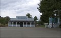
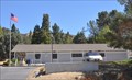 view gallery view galleryN8.4 km |  Lake Hughes, California 93532 Lake Hughes, California 93532
in U.S. Post Offices This Post Office is located at 16817 Elizabeth Lake Road in Lake Hughes, California. posted by: brwhiz location: California date approved: 08/20/2013 last visited: 09/28/2014 |
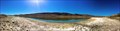 view gallery view gallery NE8.4 km NE8.4 km
|  Elizabeth Lake - Lake Hughes, CA Elizabeth Lake - Lake Hughes, CA
in Wikipedia Entries A lake along the San Andreas Fault. posted by: bluesnote location: California date approved: 11/25/2014 last visited: 11/25/2014 |
 view gallery view galleryNE8.4 km |  Elizabeth Lake - Lake Hughes, CA Elizabeth Lake - Lake Hughes, CA
in Places of Geologic Significance A lake along the San Andreas Fault. posted by: bluesnote location: California date approved: 11/26/2014 last visited: 11/26/2014 |
 view gallery view galleryNE8.4 km |  Elizabeth Lake - Lake Hughes, CA Elizabeth Lake - Lake Hughes, CA
in Natural Lakes A lake along the San Andreas Fault. posted by: bluesnote location: California date approved: 12/02/2014 last visited: 12/02/2014 |
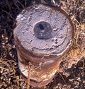
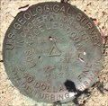 view gallery view galleryNE8.4 km |  U.S. Geological Survey K-19 Mark - Lake Hughes, CA U.S. Geological Survey K-19 Mark - Lake Hughes, CA
in U.S. Benchmarks This is one of a few benchmarks in the area. posted by: bluesnote location: California date approved: 10/20/2014 last visited: 10/20/2014 |
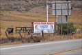
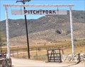
 view gallery view galleryNE8.9 km |  Pitch Fork Ranch Entrance Arch Pitch Fork Ranch Entrance Arch
in Freestanding Arches This Freestanding Arch marks the entrance to the Pitch Fork Llama Ranch, located at 13500 Lake Elizabeth Road between Lake Hughes and Leona Valley, California. posted by: brwhiz location: California date approved: 08/23/2013 last visited: never |
 view gallery view galleryNE8.9 km |  Pitch Fork Ranch ~ Lake Hughes, California Pitch Fork Ranch ~ Lake Hughes, California
in Alpaca and Llama Farms This Llama Ranch is located at 13500 Lake Elizabeth Road between Lake Hughes and Leona Valley, California posted by: brwhiz location: California date approved: 08/24/2013 last visited: never |
 view gallery view galleryNE8.9 km |  Pitch Fork Ranch ~ Lake Hughes, California Pitch Fork Ranch ~ Lake Hughes, California
in Named Farms and Ranches This Named Ranch is located at 13500 Lake Elizabeth Road between Lake Hughes and Leona Valley, California posted by: brwhiz location: California date approved: 08/22/2013 last visited: never |
 view gallery view galleryNE8.9 km |  Switching Station, Elizabeth Lake, CA Switching Station, Elizabeth Lake, CA
in Historic Transformer Sub-Stations Buildings Abandoned power distribution station built in 1911 for the Pacific Electric Railway. posted by:  CraigBaker CraigBaker location: California date approved: 02/27/2024 last visited: never |
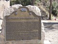 view gallery view gallery SW10.1 km SW10.1 km
|  ST. FRANCIS DAM DISASTER SITE ST. FRANCIS DAM DISASTER SITE
in California Historical Markers Pumphouse 2 was destroyed by the catastrophic failure of the St. Francisquito Dam in 1928 along with many other buildings and people between this point and Ventura. posted by: TerryDad2 location: California date approved: 03/18/2007 last visited: 04/06/2018 |
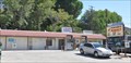 view gallery view gallery E14.6 km E14.6 km
| Leona Valley, California 93551 ~ Rancher's Market CPU in U.S. Post Offices This Contract Postal Unit is inside the Rancher's Market located at 9001 Elizabeth Lake Road in Leona Valley, California. posted by: brwhiz location: California date approved: 08/22/2013 last visited: 09/28/2014 |
 view gallery view gallery SE16.3 km SE16.3 km
|  Agua Dulce Women's Club - Agua Dulce, CA Agua Dulce Women's Club - Agua Dulce, CA
in Woman's Clubs The club is a non-profit organization that focuses on the community, especially the children. The Women's Club building is the only community owned building in the town. posted by: Free2bme29 location: California date approved: 02/24/2009 last visited: 12/04/2010 |
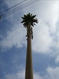 view gallery view gallery S16.6 km S16.6 km
|  Sierra Highway Palm Tree - Canyon Country, CA Sierra Highway Palm Tree - Canyon Country, CA
in Disguised Cell Towers A tall palm tree with a pale trunk! posted by: Free2bme29 location: California date approved: 06/05/2009 last visited: 04/03/2011 |
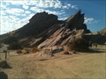
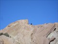 view gallery view gallerySE16.9 km | Vasquez Rocks, CA in Places of Geologic Significance Cool rock formations in northern LA county. The area has been used in many movies and commercials. It's a great place for rock climbing, hiking, horseback riding, picnicking... posted by: Free2bme29 location: California date approved: 01/04/2009 last visited: 03/12/2017 |
 view gallery view gallerySW17.1 km |  Water Dam - Castaic, CA USA Water Dam - Castaic, CA USA
in Water Dams Castaic Lake State Recreation Area
32132 Castaic Lake Drive
Castaic, CA 91384
661) 257-4050 posted by: CacheKidz! location: California date approved: 05/21/2017 last visited: 03/18/2018 |
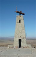 view gallery view galleryN17.4 km |  Mystery Tower Mystery Tower
in Weird Story Locations The mystery tower west of Lancaster posted by: GKrynen location: California date approved: 02/11/2009 last visited: 08/18/2010 |
 view gallery view gallerySE17.7 km |  "Gorn Rock" -- Vasquez Rocks Natural Area "Gorn Rock" -- Vasquez Rocks Natural Area
in Star Trek Well-known as the battleground for James T. Kirk and the Gorn captain. Officially known as Vasquez Rocks Natural Area and Nature Center, it is also known as "Kirk's Rock" and "Gorn Rock". posted by: Zaphody3k location: California date approved: 11/30/2011 last visited: 10/18/2021 |
 view gallery view galleryNE18.3 km | LA CO. ENG'R Survey Marker in U.S. Benchmarks L.A. county survey marker. Ave H and 100th St. West. Lancaster, Ca. posted by: Stars4Esther location: California date approved: 09/11/2011 last visited: never |
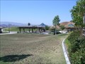
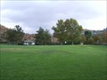 view gallery view galleryS18.7 km |  Begonias Lane Park - Santa Clarita, CA Begonias Lane Park - Santa Clarita, CA
in Municipal Parks and Plazas A neighborhood park with plenty of area to stretch out and relax. posted by: Free2bme29 location: California date approved: 09/14/2009 last visited: 01/13/2010 |
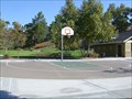
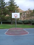 view gallery view galleryS18.7 km |  Begonias Lane Basketball Court - Santa Clarita, CA Begonias Lane Basketball Court - Santa Clarita, CA
in Outdoor Basketball Courts One full court located at the Begonias Lane Park. posted by: Free2bme29 location: California date approved: 09/16/2009 last visited: 04/12/2011 |
 view gallery view galleryS18.8 km | Todd Longshore Park - Santa Clarita, CA in Municipal Parks and Plazas This park offers great views of the Santa Clarita Valley. posted by: Free2bme29 location: California date approved: 09/16/2009 last visited: 07/16/2020 |
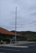 view gallery view gallerySE19 km |  Flagpole - Agua Dulce, CA Flagpole - Agua Dulce, CA
in Eagle Scout Project Sites A flagpole in front of the LDS curch in Agua Dulce. posted by: Free2bme29 location: California date approved: 02/22/2009 last visited: 04/15/2009 |
 view gallery view galleryS19 km | Oak Spring Canyon Park Court - Santa Clarita, CA in Outdoor Basketball Courts This half-court is located in a quiet neighborhood park. posted by: Free2bme29 location: California date approved: 09/16/2009 last visited: 01/31/2014 |
|