 view gallery view gallery N0.5 km N0.5 km
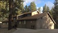
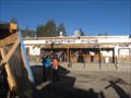
|   Wrightwood Public Library - Wrightwood, CA Wrightwood Public Library - Wrightwood, CA
in Libraries A public library in downtown Wrightwood. posted by:  bluesnote bluesnote location: California date approved: 05/27/2016 last visited: 05/27/2016 |
 view gallery view gallery NE0.6 km NE0.6 km
|  Wrightwood, California Wrightwood, California
in Wikipedia Entries The above coordinates are for the post office in town. posted by: bluesnote location: California date approved: 03/24/2016 last visited: 03/24/2016 |
 view gallery view galleryNE0.6 km |  Wrightwood, California Wrightwood, California
in American Guide Series The above coordinates are for the post office in town. posted by: bluesnote location: California date approved: 03/25/2016 last visited: 03/25/2016 |
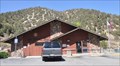 view gallery view galleryNE0.6 km |  Wrightwood, California 92397 Wrightwood, California 92397
in U.S. Post Offices This Post Office is located at 1440 State Highway 2 in Wrightwood, California. posted by: brwhiz location: California date approved: 08/22/2013 last visited: 03/05/2016 |
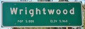
 view gallery view gallery E1 km E1 km
|  Wrightwood ~ Population 5000 Wrightwood ~ Population 5000
in Population Signs This combination Elevation/Population sign is on the north side of Angeles Crest Highway (California 2) at the eastern city limits of Wrightwood, California. posted by: brwhiz location: California date approved: 08/25/2013 last visited: never |
 view gallery view galleryE1 km |  Wrightwood ~ Elevation 5960 Wrightwood ~ Elevation 5960
in Elevation Signs This combination Elevation/Population sign is on the north side of Angeles Crest Highway (California 2) at the eastern city limits of Wrightwood, California. posted by: brwhiz location: California date approved: 08/23/2013 last visited: never |
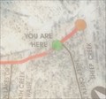 view gallery view galleryE1.9 km |  Trail Map - Wrightwood, CA Trail Map - Wrightwood, CA
in 'You Are Here' Maps A trail map along Highway 2. posted by: bluesnote location: California date approved: 11/27/2014 last visited: 11/27/2014 |
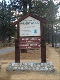
 view gallery view galleryE1.9 km |  Wrightwood, CA Wrightwood, CA
in Welcome Signs A Welcome sign along Highway 2. posted by: bluesnote location: California date approved: 11/25/2014 last visited: 11/25/2014 |
 view gallery view galleryE1.9 km | Wrightwood, CA - Elevation 6,000 in Elevation Signs An elevation sign along Highway 2. posted by: bluesnote location: California date approved: 11/25/2014 last visited: 11/25/2014 |
 view gallery view galleryE1.9 km | Wrightwood, CA - Population 5,000 in Population Signs A population sign along Highway 2. posted by: bluesnote location: California date approved: 03/12/2015 last visited: 03/12/2015 |
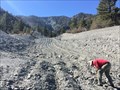 view gallery view gallery SE2.3 km SE2.3 km
|  Heath Canyon - Wrightwood, CA Heath Canyon - Wrightwood, CA
in Places of Geologic Significance A nearby Landslide created a small canyon where green crystals, actinolite, can be found. posted by: bluesnote location: California date approved: 11/26/2014 last visited: 11/26/2014 |
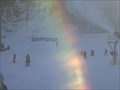 view gallery view gallery NW4.5 km NW4.5 km
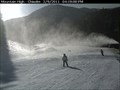
|  Mt. High Playground Web Cam - Wrightwood, CA Mt. High Playground Web Cam - Wrightwood, CA
in Web Cameras This is one of four webcams in Mt. High. posted by: bluesnote location: California date approved: 02/11/2011 last visited: 02/11/2011 |
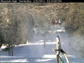 view gallery view gallery W5.3 km W5.3 km
| Borderline Web Cam - Wrightwood, CA in Web Cameras This is one of four webcams at Mt. High. posted by: bluesnote location: California date approved: 02/11/2011 last visited: 02/11/2011 |
 view gallery view galleryNW5.5 km | Mt. High East Web Cam - Wrightwood, CA in Web Cameras This is one of four webcams in Mt. High. posted by: bluesnote location: California date approved: 02/11/2011 last visited: 02/11/2011 |
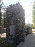 view gallery view galleryNW5.6 km |  Big Pines Arch - Wrightwood, CA Big Pines Arch - Wrightwood, CA
in Look-Out Towers This tower used to have a twin to connect an arch, but now it serves as a look out tower. posted by: bluesnote location: California date approved: 11/02/2014 last visited: 11/02/2014 |
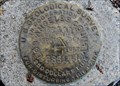 view gallery view galleryNW5.6 km |  Benchmark RS 1924 - PID EV2546 Benchmark RS 1924 - PID EV2546
in U.S. Benchmarks Benchmark located at Big Pine Lodge / Ranger Station on Hwy 2, in the Angeles National Forest. posted by:  Vader! Vader! location: California date approved: 07/12/2009 last visited: 09/28/2014 |
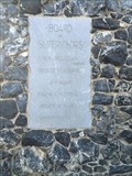 view gallery view galleryNW5.6 km | Big Pines Arch - Wrightwood, CA - Elevation 6861.94 in Elevation Signs A small elevation sign on the Big Pines Arch, or what's left of it. posted by: bluesnote location: California date approved: 10/29/2014 last visited: 10/29/2014 |
 view gallery view galleryNW5.6 km | Mountain High - Wrightwood, CA in Wikipedia Entries One of the most popular places in Southern California during the winter season. posted by: bluesnote location: California date approved: 05/02/2016 last visited: 05/02/2016 |
 view gallery view galleryNW5.6 km |  Mountain High - Wrightwood, CA Mountain High - Wrightwood, CA
in Winter Sports Locations One of the most popular places in Southern California during the winter season. posted by: bluesnote location: California date approved: 05/03/2016 last visited: 05/03/2016 |
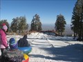 view gallery view galleryNW5.6 km |  Mountain High Tube Run - Wrightwood, CA Mountain High Tube Run - Wrightwood, CA
in Sledding Places This section of Mountain High has a tubbing run, where one can go sledding when there's enough snow. posted by: bluesnote location: California date approved: 05/03/2016 last visited: 05/03/2016 |
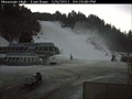
 view gallery view galleryW5.8 km | Mt. High Web Cam - Wrightwood, CA in Web Cameras This is one of four webcams in Mt. High. posted by: bluesnote location: California date approved: 02/11/2011 last visited: 02/11/2011 |
 view gallery view gallery S7.6 km S7.6 km
|  Mt. San Antonio - Mt. Baldy, CA Mt. San Antonio - Mt. Baldy, CA
in Geographic High Points The highest peak in the San Gabriel Mountains and Los Angeles County! posted by: bluesnote location: California date approved: 12/14/2013 last visited: 04/21/2015 |
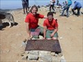
 view gallery view galleryS7.6 km |  Mt. San Antonio, a.k.a. Mt. Baldy, California Mt. San Antonio, a.k.a. Mt. Baldy, California
in Mountain Summits Mt. San Antonio is a 10,064 foot peak in the San Gabriel Mountains in the Angeles National Forest. posted by: showbizkid location: California date approved: 01/24/2006 last visited: 06/25/2013 |
 view gallery view galleryS7.6 km | Mt. San Antonio - Mt. Baldy, CA in Wikipedia Entries The highest peak in the San Gabriel Mountains! posted by: bluesnote location: California date approved: 12/01/2013 last visited: 08/18/2019 |
 view gallery view galleryS7.6 km | Mt. San Antonio - Mt. Baldy, CA in Elevation Signs The highest peak in the San Gabriel Mountains! posted by: bluesnote location: California date approved: 12/05/2013 last visited: 12/05/2013 |
|