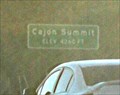
 view gallery view gallery E1.1 km E1.1 km
|   4260ft - Cajon Summit CA 4260ft - Cajon Summit CA
in Elevation Signs This sign marks the Cajon Summit on the southbound I-15: 4260 feet above sea level posted by:  Benchmark Blasterz Benchmark Blasterz location: California date approved: 04/02/2016 last visited: 07/16/2016 |
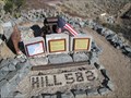 view gallery view gallery S1.6 km S1.6 km
|  Hill 582 Tribute - Cajon, CA Hill 582 Tribute - Cajon, CA
in Active Rail Locations Cajon Hill 582 is known as a railfanning sanctuary and a place of solace. It is also a memorial to William B Garner, Michael John Marzlo, Ed Delvers, and Dave Burton. Please Respect This Area, as there has been vandalism in the past. posted by:  DopeyDuck DopeyDuck location: California date approved: 01/28/2009 last visited: never |
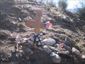 view gallery view galleryE1.8 km |  Mercy Air Crash - Cajon, CA Mercy Air Crash - Cajon, CA
in Plane Crash Sites On Dec 10, 2008, a paramedic helicopter returning from dropping off a patient crashed in the mountainous Cajon pass during foggy conditions. posted by: DopeyDuck location: California date approved: 01/29/2009 last visited: 11/28/2014 |
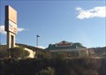 view gallery view gallery SW4.7 km SW4.7 km
|  McDonald's - Wagon Trail Rd. - Phelan, CA McDonald's - Wagon Trail Rd. - Phelan, CA
in Wi-Fi Hotspots A McDonalds right off of Interstate 15. posted by: bluesnote location: California date approved: 08/24/2014 last visited: 08/24/2014 |
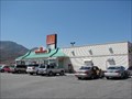 view gallery view gallerySW4.7 km |  McDonald's - Wagon Trail Rd. - Phelan, CA McDonald's - Wagon Trail Rd. - Phelan, CA
in McDonald's Restaurants McDonalds at Cajon Junction, CA. posted by: JacobBarlow location: California date approved: 04/02/2007 last visited: 08/20/2014 |
 view gallery view gallerySW4.7 km |  SUBWAY - Cajon Junction, CA SUBWAY - Cajon Junction, CA
in Subway Restaurants This SUBWAY is right off the interstate at a gas station. posted by: JacobBarlow location: California date approved: 01/22/2008 last visited: 06/04/2008 |
 view gallery view galleryS4.8 km |  How Many Miles? - Cajon Pass, CA How Many Miles? - Cajon Pass, CA
in Route 66 - The Mother Road A map along the PCT at Route 66, showing how many miles you are from Mexico and Canada. posted by: bluesnote location: California date approved: 06/29/2015 last visited: 06/29/2015 |
 view gallery view galleryS4.8 km |  Old Spanish National Historic Trail - Arizona, California, Colorado, Nevada, New Mexico, Utah Old Spanish National Historic Trail - Arizona, California, Colorado, Nevada, New Mexico, Utah
in Wikipedia Entries A national historic trail that crosses the Cajon Pass in Southern California, connecting Los Angeles to Santa Fe. posted by: bluesnote location: California date approved: 02/08/2024 last visited: never |
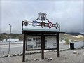 view gallery view galleryS4.8 km |  Welcome to Camp Cajon - Phelan, CA Welcome to Camp Cajon - Phelan, CA
in Signs of History One of many historical markers along Route 66 in Phelan, California. posted by: bluesnote location: California date approved: 02/09/2024 last visited: never |
 view gallery view galleryS4.8 km |  Old Spanish National Historic Trail - Arizona, California, Colorado, Nevada, New Mexico, Utah Old Spanish National Historic Trail - Arizona, California, Colorado, Nevada, New Mexico, Utah
in U.S. National Register of Historic Places A national historic trail that crosses the Cajon Pass in Southern California, connecting Los Angeles to Santa Fe. posted by: bluesnote location: California date approved: 02/10/2024 last visited: never |
 view gallery view galleryS4.8 km |  FIRST -- Ocean to Ocean Highway - Phelan, CA FIRST -- Ocean to Ocean Highway - Phelan, CA
in First of its Kind One of many historical markers along Route 66 in Phelan, California. posted by: bluesnote location: California date approved: 02/08/2024 last visited: never |
 view gallery view galleryS4.8 km |  Old Spanish National Historic Trail - Arizona, California, Colorado, Nevada, New Mexico, Utah Old Spanish National Historic Trail - Arizona, California, Colorado, Nevada, New Mexico, Utah
in National Parks of the World A national historic trail that crosses the Cajon Pass in Southern California, connecting Los Angeles to Santa Fe. posted by: bluesnote location: California date approved: 02/17/2024 last visited: never |
 view gallery view galleryS4.8 km | Welcome to Camp Cajon - Phelan, CA in Route 66 - The Mother Road One of many historical markers along Route 66 in Phelan, California. posted by: bluesnote location: California date approved: 02/09/2024 last visited: never |
 view gallery view galleryS4.8 km |  OLDEST -- Ocean to Ocean Highway - Phelan, CA OLDEST -- Ocean to Ocean Highway - Phelan, CA
in Superlatives One of many historical markers along Route 66 in Phelan, California. posted by: bluesnote location: California date approved: 02/09/2024 last visited: never |
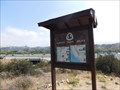
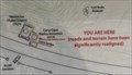 view gallery view galleryS4.8 km |  Welcome to Camp Cajon "You are Here" Map - Phelan, CA Welcome to Camp Cajon "You are Here" Map - Phelan, CA
in 'You Are Here' Maps One of many historical markers along Route 66 in Phelan, California. posted by: bluesnote location: California date approved: 02/08/2024 last visited: never |
 view gallery view galleryS4.8 km |  Welcome to Camp Cajon - Historic Route 66 - Phelan, CA Welcome to Camp Cajon - Historic Route 66 - Phelan, CA
in National Scenic Byways One of many historical markers along Route 66 in Phelan, California. posted by: bluesnote location: California date approved: 02/10/2024 last visited: never |
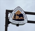
 view gallery view galleryS4.8 km |  Old Spanish National Historic Trail - Phelan, CA Old Spanish National Historic Trail - Phelan, CA
in Hiking and walking trailheads A trailhead for the Old Spanish National Historic Trail in Phelan, California. posted by: bluesnote location: California date approved: 02/09/2024 last visited: never |
 view gallery view galleryS4.8 km | Cajon Pass - Phelan, CA in Wikipedia Entries The main artery connecting the Inland Empire and the high desert. The Cajon Pass was formed by the San Andreas fault and is the transition between the San Gabriel and San Bernardino mountains. It carries major routes including US 66, US 395 and I-15. posted by: bluesnote location: California date approved: 02/08/2024 last visited: never |
 view gallery view galleryS4.8 km |  Cajon Pass - Phelan, CA Cajon Pass - Phelan, CA
in Satellite Imagery Oddities The main artery connecting the Inland Empire and the high desert. The Cajon Pass was formed by the San Andreas fault and is the transition between the San Gabriel and San Bernardino mountains. It carries major routes including US 66, US 395 and I-15. posted by: bluesnote location: California date approved: 02/08/2024 last visited: never |
 view gallery view galleryS4.8 km |  William M. Bristol - Phelan, CA William M. Bristol - Phelan, CA
in Citizen Memorials A large monument in Phelan, California. posted by: bluesnote location: California date approved: 02/08/2024 last visited: never |
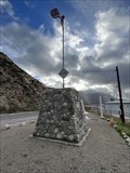
 view gallery view galleryS4.8 km |  Camp Cajon - 100 Years - Phelan, CA Camp Cajon - 100 Years - Phelan, CA
in Commercial Commemorations A large monument in Phelan, California. posted by: bluesnote location: California date approved: 02/09/2024 last visited: never |
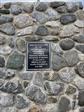
 view gallery view galleryS4.8 km |  Charles L. Frazer - Camp Cajon - Phelan, CA Charles L. Frazer - Camp Cajon - Phelan, CA
in Etched in Stone A large monument in Phelan, California. posted by: bluesnote location: California date approved: 02/14/2024 last visited: never |
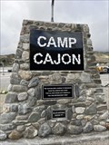 view gallery view galleryS4.8 km |  Camp Cajon - Phelan, CA Camp Cajon - Phelan, CA
in Cairns A large monument in Phelan, California. posted by: bluesnote location: California date approved: 02/08/2024 last visited: never |
 view gallery view galleryS4.8 km |  Camp Cajon - Phelan, CA Camp Cajon - Phelan, CA
in Ghost Towns A large monument in Phelan, California. posted by: bluesnote location: California date approved: 02/14/2024 last visited: never |
 view gallery view galleryS4.8 km |  Cajon Pass - Phelan, CA Cajon Pass - Phelan, CA
in Named Mountain Gaps The main artery connecting the Inland Empire and the high desert. The Cajon Pass was formed by the San Andreas fault and is the transition between the San Gabriel and San Bernardino mountains. It carries major routes including US 66, US 395 and I-15. posted by: bluesnote location: California date approved: 02/17/2024 last visited: never |
|