 view gallery view gallery W0.3 km W0.3 km
|   SUBWAY - Cajon Junction, CA SUBWAY - Cajon Junction, CA
in Subway Restaurants This SUBWAY is right off the interstate at a gas station. posted by:  JacobBarlow JacobBarlow location: California date approved: 01/22/2008 last visited: 06/04/2008 |
 view gallery view gallery SE0.5 km SE0.5 km
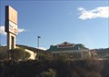
|  McDonald's - Wagon Trail Rd. - Phelan, CA McDonald's - Wagon Trail Rd. - Phelan, CA
in Wi-Fi Hotspots A McDonalds right off of Interstate 15. posted by: bluesnote location: California date approved: 08/24/2014 last visited: 08/24/2014 |
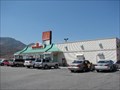 view gallery view gallerySE0.5 km |  McDonald's - Wagon Trail Rd. - Phelan, CA McDonald's - Wagon Trail Rd. - Phelan, CA
in McDonald's Restaurants McDonalds at Cajon Junction, CA. posted by: JacobBarlow location: California date approved: 04/02/2007 last visited: 08/20/2014 |
 view gallery view gallerySE1 km |  Old Spanish National Historic Trail - Arizona, California, Colorado, Nevada, New Mexico, Utah Old Spanish National Historic Trail - Arizona, California, Colorado, Nevada, New Mexico, Utah
in U.S. National Register of Historic Places A national historic trail that crosses the Cajon Pass in Southern California, connecting Los Angeles to Santa Fe. posted by: bluesnote location: California date approved: 02/10/2024 last visited: never |
 view gallery view gallerySE1 km |  FIRST -- Ocean to Ocean Highway - Phelan, CA FIRST -- Ocean to Ocean Highway - Phelan, CA
in First of its Kind One of many historical markers along Route 66 in Phelan, California. posted by: bluesnote location: California date approved: 02/08/2024 last visited: never |
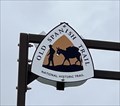 view gallery view gallerySE1 km |  Old Spanish National Historic Trail - Arizona, California, Colorado, Nevada, New Mexico, Utah Old Spanish National Historic Trail - Arizona, California, Colorado, Nevada, New Mexico, Utah
in National Parks of the World A national historic trail that crosses the Cajon Pass in Southern California, connecting Los Angeles to Santa Fe. posted by: bluesnote location: California date approved: 02/17/2024 last visited: never |
 view gallery view gallerySE1 km |  Welcome to Camp Cajon - Phelan, CA Welcome to Camp Cajon - Phelan, CA
in Signs of History One of many historical markers along Route 66 in Phelan, California. posted by: bluesnote location: California date approved: 02/09/2024 last visited: never |
 view gallery view gallerySE1 km |  Old Spanish National Historic Trail - Arizona, California, Colorado, Nevada, New Mexico, Utah Old Spanish National Historic Trail - Arizona, California, Colorado, Nevada, New Mexico, Utah
in Wikipedia Entries A national historic trail that crosses the Cajon Pass in Southern California, connecting Los Angeles to Santa Fe. posted by: bluesnote location: California date approved: 02/08/2024 last visited: never |
 view gallery view gallerySE1 km |  OLDEST -- Ocean to Ocean Highway - Phelan, CA OLDEST -- Ocean to Ocean Highway - Phelan, CA
in Superlatives One of many historical markers along Route 66 in Phelan, California. posted by: bluesnote location: California date approved: 02/09/2024 last visited: never |
 view gallery view gallerySE1 km |  Welcome to Camp Cajon - Phelan, CA Welcome to Camp Cajon - Phelan, CA
in Route 66 - The Mother Road One of many historical markers along Route 66 in Phelan, California. posted by: bluesnote location: California date approved: 02/09/2024 last visited: never |
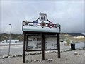
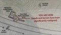 view gallery view gallerySE1 km |  Welcome to Camp Cajon "You are Here" Map - Phelan, CA Welcome to Camp Cajon "You are Here" Map - Phelan, CA
in 'You Are Here' Maps One of many historical markers along Route 66 in Phelan, California. posted by: bluesnote location: California date approved: 02/08/2024 last visited: never |
 view gallery view gallerySE1 km |  Welcome to Camp Cajon - Historic Route 66 - Phelan, CA Welcome to Camp Cajon - Historic Route 66 - Phelan, CA
in National Scenic Byways One of many historical markers along Route 66 in Phelan, California. posted by: bluesnote location: California date approved: 02/10/2024 last visited: never |
 view gallery view gallerySE1 km |  Old Spanish National Historic Trail - Phelan, CA Old Spanish National Historic Trail - Phelan, CA
in Hiking and walking trailheads A trailhead for the Old Spanish National Historic Trail in Phelan, California. posted by: bluesnote location: California date approved: 02/09/2024 last visited: never |
 view gallery view gallerySE1 km |  Camp Cajon - Phelan, CA Camp Cajon - Phelan, CA
in Ghost Towns A large monument in Phelan, California. posted by: bluesnote location: California date approved: 02/14/2024 last visited: never |
 view gallery view gallerySE1 km |  Cajon Pass - Phelan, CA Cajon Pass - Phelan, CA
in Satellite Imagery Oddities The main artery connecting the Inland Empire and the high desert. The Cajon Pass was formed by the San Andreas fault and is the transition between the San Gabriel and San Bernardino mountains. It carries major routes including US 66, US 395 and I-15. posted by: bluesnote location: California date approved: 02/08/2024 last visited: never |
 view gallery view gallerySE1 km |  William M. Bristol - Phelan, CA William M. Bristol - Phelan, CA
in Citizen Memorials A large monument in Phelan, California. posted by: bluesnote location: California date approved: 02/08/2024 last visited: never |
 view gallery view gallerySE1 km |  Camp Cajon - 100 Years - Phelan, CA Camp Cajon - 100 Years - Phelan, CA
in Commercial Commemorations A large monument in Phelan, California. posted by: bluesnote location: California date approved: 02/09/2024 last visited: never |
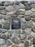
 view gallery view gallerySE1 km |  Charles L. Frazer - Camp Cajon - Phelan, CA Charles L. Frazer - Camp Cajon - Phelan, CA
in Etched in Stone A large monument in Phelan, California. posted by: bluesnote location: California date approved: 02/14/2024 last visited: never |
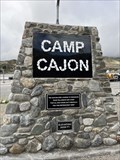 view gallery view gallerySE1 km |  Camp Cajon - Phelan, CA Camp Cajon - Phelan, CA
in Cairns A large monument in Phelan, California. posted by: bluesnote location: California date approved: 02/08/2024 last visited: never |
 view gallery view gallerySE1 km | Cajon Pass - Phelan, CA in Wikipedia Entries The main artery connecting the Inland Empire and the high desert. The Cajon Pass was formed by the San Andreas fault and is the transition between the San Gabriel and San Bernardino mountains. It carries major routes including US 66, US 395 and I-15. posted by: bluesnote location: California date approved: 02/08/2024 last visited: never |
 view gallery view gallerySE1 km |  Cajon Pass - Phelan, CA Cajon Pass - Phelan, CA
in Named Mountain Gaps The main artery connecting the Inland Empire and the high desert. The Cajon Pass was formed by the San Andreas fault and is the transition between the San Gabriel and San Bernardino mountains. It carries major routes including US 66, US 395 and I-15. posted by: bluesnote location: California date approved: 02/17/2024 last visited: never |
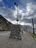
 view gallery view gallerySE1 km |  Camp Cajon - Phelan, CA ~ Elevation 3002 ft. Camp Cajon - Phelan, CA ~ Elevation 3002 ft.
in Elevation Signs A large monument in Phelan, California. posted by: bluesnote location: California date approved: 02/10/2024 last visited: never |
 view gallery view gallerySE1 km | Camp Cajon - Phelan, CA in Route 66 - The Mother Road A large monument in Phelan, California. posted by: bluesnote location: California date approved: 02/09/2024 last visited: never |
 view gallery view gallerySE1 km | Cajon Pass - Phelan, CA in Route 66 - The Mother Road The main artery connecting the Inland Empire and the high desert. The Cajon Pass was formed by the San Andreas fault and is the transition between the San Gabriel and San Bernardino mountains. It carries major routes including US 66, US 395 and I-15. posted by: bluesnote location: California date approved: 02/11/2024 last visited: never |
 view gallery view gallerySE1 km | Cajon Pass - Historic Route 66 - Phelan, CA in National Scenic Byways The main artery connecting the Inland Empire and the high desert. The Cajon Pass was formed by the San Andreas fault and is the transition between the San Gabriel and San Bernardino mountains. It carries major routes including US 66, US 395 and I-15. posted by: bluesnote location: California date approved: 02/24/2024 last visited: never |
|