 view gallery view gallery S4.5 km S4.5 km
|   Fire Department Siren - Calhoun Falls, SC Fire Department Siren - Calhoun Falls, SC
in Outdoor Warning Sirens Located in Calhoun Falls, SC. posted by:  Firefrog69 Firefrog69 location: South Carolina date approved: 12/21/2008 last visited: never |
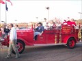
 view gallery view galleryS4.5 km |  Chief's Car - Calhoun Falls Fire Dept.- Calhoun Falls, SC Chief's Car - Calhoun Falls Fire Dept.- Calhoun Falls, SC
in Fire Fighting Vehicles Located in Calhoun Falls South Carolina. posted by: Firefrog69 location: South Carolina date approved: 12/21/2008 last visited: never |
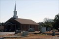
 view gallery view galleryS4.5 km | Calhoun Falls Fire Dept. in Firehouses Located in Calhoun Falls South Carolina. posted by: Firefrog69 location: South Carolina date approved: 12/21/2008 last visited: never |
 view gallery view galleryS4.7 km |  7-eleven #36851 Calhoun Falls, SC 7-eleven #36851 Calhoun Falls, SC
in 7-Eleven Stores 7-eleven store located in Calhoun Falls, SC posted by: gpsblake location: South Carolina date approved: 12/27/2014 last visited: never |
 view gallery view gallery SE5 km SE5 km
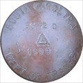
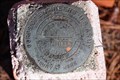
|  Highway 72 Abbeville Highway 72 Abbeville
in U.S. Benchmarks Stamped SCDOT disk located 24 feet south from end of pavement off state road S-01-268 posted by: OXCACHER location: South Carolina date approved: 01/05/2007 last visited: 01/05/2007 |
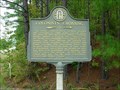
 view gallery view gallery SW7.9 km SW7.9 km
|  Millwood Millwood
in South Carolina Historical Markers Marker is in Calhoun Falls, South Carolina, in Abbeville County. Marker is on Calhoun Falls Highway (State Highway 72), on the right when traveling west. Marker is directly across Highway 72 from the Olin D. Johnston marker. The Millwood Marker is about 35 feet off the road in a grove of trees posted by: mr.volkswagen location: South Carolina date approved: 09/08/2010 last visited: never |
 view gallery view gallerySW9.7 km |  Colonist's Crossing-GHM 052-8A-Elbert Co Colonist's Crossing-GHM 052-8A-Elbert Co
in Georgia Historical Markers Ga 72 about 1 mile west of the Savannah River posted by:  Sprinterman Sprinterman location: Georgia date approved: 10/31/2009 last visited: 02/20/2010 |
 view gallery view gallery NE9.7 km NE9.7 km
|  Abbeville Country Truss Abbeville Country Truss
in Truss Bridges Old truss bridge on Hagler St extension in Abbeville County. posted by: OXCACHER location: South Carolina date approved: 01/03/2007 last visited: never |
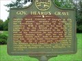 view gallery view gallery W9.8 km W9.8 km
| Gov. Heard's Grave-GHM 052-5-Elbert Co in Georgia Historical Markers At DAR park in Heardmont, north of Ga 72 posted by: Sprinterman location: Georgia date approved: 10/30/2009 last visited: 10/10/2009 |
 view gallery view gallerySW11.3 km |  Fleming Cemetery - Elberton, GA Fleming Cemetery - Elberton, GA
in Worldwide Cemeteries The Fleming Cemetery is located on Cut-Through Rd at Welcome Church Road, Elberton, GA. There are between 100 and 200 headstones in the cemetery. posted by: Lat34North location: Georgia date approved: 04/27/2010 last visited: 02/20/2010 |
 view gallery view gallerySW11.4 km | Bethlehem Methodist Church-GHM 052-7-Elbert Co in Georgia Historical Markers Just off Ga 72 about 12 miles southeast of Elberton posted by: Sprinterman location: Georgia date approved: 10/30/2009 last visited: 02/20/2010 |
 view gallery view gallerySW11.4 km |  L. D. Hall - Bethlehem Methodist Church cemetery – Elberton, GA L. D. Hall - Bethlehem Methodist Church cemetery – Elberton, GA
in Woodmen of the World Grave Markers/Monuments Bethlehem Methodist Church cemetery is located at the church on Welcome Church Road, Elberton, GA. posted by: Lat34North location: Georgia date approved: 04/27/2010 last visited: 02/20/2010 |
 view gallery view gallerySW11.4 km | Bethlehem Methodist Church cemetery – Elberton, GA in Worldwide Cemeteries Bethlehem Methodist Church cemetery is located at the church on Welcome Church Road, Elberton, GA. There are 400 to 500 headstones. posted by: Lat34North location: Georgia date approved: 04/27/2010 last visited: 02/20/2010 |
 view gallery view gallerySW11.4 km |  Bethlehem Methodist Church cemetery – Elberton, GA Bethlehem Methodist Church cemetery – Elberton, GA
in Churchyard Cemeteries Bethlehem Methodist Church cemetery is located at the church on Welcome Church Road, Elberton, GA. There are 400 to 500 headstones. posted by: Lat34North location: Georgia date approved: 04/30/2010 last visited: 01/20/2010 |
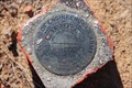 view gallery view gallerySW11.6 km | U.S. Army Corp of Engineers – 3G0028-4 - Lake Hartwell, Elberton, GA in U.S. Benchmarks U.S. Army Corp of Engineers disk stamped 3G0028-4, 1975 is located north of Calhoun Falls Highway (GA 72) and west of Marina Dr. posted by: Lat34North location: Georgia date approved: 03/05/2010 last visited: 02/20/2010 |
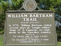 view gallery view galleryNE11.7 km |  William Bartram Trail - Abbeville, South Carolina William Bartram Trail - Abbeville, South Carolina
in Bartram Trail Historical Markers Located west of Abbeyville on Hwy 71, about 6 miles out of town. posted by: jhuoni location: South Carolina date approved: 04/12/2015 last visited: never |
 view gallery view galleryS11.9 km | U.S. Army Corp of Engineers – G0009 – Lake Hartwell, Elberton, GA. in U.S. Benchmarks U.S. Army Corp of Engineers – G0009 located north of the Tates Grove Cemetery on the east side of Bobby Brown State Park Road, Elberton, GA. posted by: Lat34North location: Georgia date approved: 03/05/2010 last visited: 02/20/2010 |
 view gallery view galleryS11.9 km | Tates Grove Cemetery - Elberton, GA in Worldwide Cemeteries Tates Grove Cemetery is located on Bobby Brown State Park Road north of Russell Dam Road. There are 100 to 200 headstones in the cemetery. posted by: Lat34North location: Georgia date approved: 03/02/2010 last visited: 02/20/2010 |
 view gallery view galleryNE13.5 km | Williamston VFD - Eng.1 - Williamston , SC in Fire Fighting Vehicles A retired pumper,this apparatus is now used in parades and car shows. posted by: Firefrog69 location: South Carolina date approved: 12/08/2007 last visited: never |
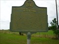
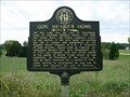 view gallery view gallerySW15.4 km | Gov. Heard's Home-GHM 052-4-Elbert Co in Georgia Historical Markers Ga 72 at road to Heardmont, southeast of Middleton posted by: Sprinterman location: Georgia date approved: 10/30/2009 last visited: 05/12/2005 |
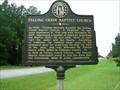 view gallery view gallerySW15.4 km | Falling Creek Baptist Church-GHM 052-11-Elbert Co in Georgia Historical Markers Ga 77 about 3 miles south of Elberton posted by: Sprinterman location: Georgia date approved: 10/30/2009 last visited: 02/20/2010 |
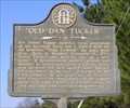 view gallery view gallerySW15.4 km | Old Dan Tucker - 052-12 in Georgia Historical Markers A marker along highway 72 near the home site and burial place of Daniel Tucker. posted by:  NevaP NevaP location: Georgia date approved: 02/13/2007 last visited: 05/12/2005 |
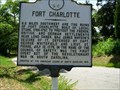 view gallery view gallerySE16.1 km | Fort Charlotte-SCHM 33-1-McCormick Co in South Carolina Historical Markers Intersection of SC 81 and Road 91 in Mt. Carmel posted by: Sprinterman location: South Carolina date approved: 07/07/2009 last visited: 07/04/2009 |
 view gallery view gallerySW16.4 km | Cades Chapel Baptist Church cemetery - Elberton, GA in Worldwide Cemeteries Cades Chapel Baptist Church cemetery is located at 3860 River Road, Elberton, GA. There are 500 to 600 headstones in the cemetery. posted by: Lat34North location: Georgia date approved: 03/02/2010 last visited: 02/20/2010 |
 view gallery view gallery E16.4 km E16.4 km
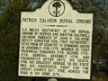
| Patrick Calhoun Family Burial Ground in South Carolina Historical Markers Easy to miss, located at the intersection of SC Highway 823 and SC Highway 72. I suggest parking and walking to this location BEHIND the GUARDRAIL. posted by: jhuoni location: South Carolina date approved: 01/16/2014 last visited: never |
|