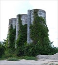
 view gallery view gallery NE7.1 km NE7.1 km
|   Danford Road - Bolivia, NC Danford Road - Bolivia, NC
in Solitary Silos These silos are on the old Family Farm. posted by:  carolina1 carolina1 location: South Carolina date approved: 09/04/2008 last visited: 10/01/2017 |
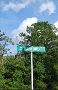 view gallery view gallery E7.7 km E7.7 km
|  Danford Road SE, Bolivia, NC Danford Road SE, Bolivia, NC
in Your Name Here Danford is my maiden name and this road was named after my great-great relatives. posted by: carolina1 location: North Carolina date approved: 09/03/2008 last visited: 10/01/2017 |
 view gallery view gallery S9 km S9 km
|  Greenwood Pet Camp and Cemetery - Bolivia, NC Greenwood Pet Camp and Cemetery - Bolivia, NC
in Pet Cemeteries Greenwood Pet Camp and Cemetery - Bolivia, North Carolina. posted by: carolina1 location: North Carolina date approved: 07/27/2007 last visited: 08/20/2016 |
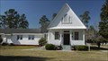 view gallery view galleryNE10.8 km |  New Hope Presbyterian Church - Winnabow,NC New Hope Presbyterian Church - Winnabow,NC
in U.S. National Register of Historic Places Rural church built in 1895. posted by:  FRESH AIR53 FRESH AIR53 location: North Carolina date approved: 02/14/2019 last visited: never |
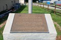 view gallery view galleryE10.9 km |  Boiling Springs Lake, NC - Firefighters Memorial Boiling Springs Lake, NC - Firefighters Memorial
in Firefighter Memorials Memory of E. C. (Dutch) Meade posted by: carolina1 location: South Carolina date approved: 09/11/2008 last visited: 09/11/2008 |
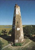 view gallery view galleryE11.9 km |  BALD HEAD LIGHTHOUSE BALD HEAD LIGHTHOUSE
in First of its Kind First lighthouse erected 1796. Present octagonal tower, built 1817, is 109 ft. tall. Used until 1935."
posted by: Countrydragon location: North Carolina date approved: 12/16/2009 last visited: 10/14/2022 |
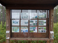 view gallery view gallery NW12.6 km NW12.6 km
|  Green Swamp Preserve, Supply, NC Green Swamp Preserve, Supply, NC
in Flora and Fauna Information Signs Located in the Green Swamp, this natural area preserve is managed by the Nature Conservancy. posted by: NCDaywalker location: North Carolina date approved: 07/23/2020 last visited: never |
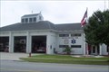 view gallery view galleryS14.3 km |  Oak Island Fire - EMS Oak Island Fire - EMS
in Firehouses This Firehouse is located on Oak Island near Middleton Street. posted by: Frippery location: North Carolina date approved: 08/23/2006 last visited: 08/20/2016 |
 view gallery view galleryS14.3 km | Oak Island Fire & Rescue in Firehouses Additional photos of firestation posted by: Frippery location: North Carolina date approved: 08/23/2006 last visited: 08/20/2016 |
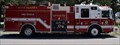 view gallery view galleryS14.3 km | Engine 171 - Oak Island Fire Dept - Oak Island, NC, USA in Fire Fighting Vehicles Engine 171 is housed at Station 1, 101 East Oak Island Drive. As a first out truck for its zone. 171 is called out for fire suppression, rescue calls, and EMS back up. It is a KME truck with a Hale Pump, electric generator and cross-lay attack lines. posted by: NCDaywalker location: North Carolina date approved: 08/24/2016 last visited: 08/26/2016 |
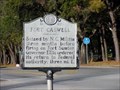
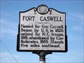 view gallery view gallery SE15.8 km SE15.8 km
|  Fort Caswell-D-8 Fort Caswell-D-8
in North Carolina Historical Markers Located on NC 133 north of Southport posted by: Countrydragon location: North Carolina date approved: 12/17/2009 last visited: 08/20/2016 |
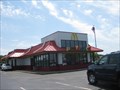 view gallery view gallerySE15.9 km |  Long Beach Rd McDs - Southport, NC Long Beach Rd McDs - Southport, NC
in McDonald's Restaurants A busy McDonalds in a coastal North Carolina town. posted by: ChapterhouseInc location: North Carolina date approved: 04/16/2010 last visited: 08/20/2016 |
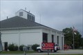
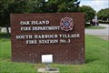 view gallery view gallerySE16.6 km | Oak Island Fire Department South Harbour Village Fire Station No. 3 in Firehouses "The Oak Island Fire and Rescue Department is a combination department that includes dedicated volunteers and career personnel." posted by: NCDaywalker location: North Carolina date approved: 08/25/2016 last visited: 08/26/2016 |
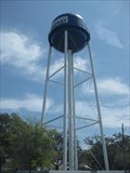
 view gallery view gallerySE17.7 km |  Oak Island Water Tower - Trott Street, Yaupon Beach, NC, USA Oak Island Water Tower - Trott Street, Yaupon Beach, NC, USA
in Water Towers Located in the heart of Yaupon Beach section of Oak Island, is can be seen for miles. posted by: NCDaywalker location: North Carolina date approved: 08/21/2016 last visited: 08/22/2016 |
 view gallery view gallerySE17.9 km | Oak Island Fire Department Yaupon Beach Fire Station 2 in Firehouses "The Oak Island Fire and Rescue Department is a combination department that includes dedicated volunteers and career personnel." posted by: NCDaywalker location: North Carolina date approved: 08/25/2016 last visited: 08/26/2016 |
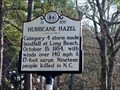 view gallery view gallerySE17.9 km | Hurricane Hazel-D-109 in North Carolina Historical Markers Marker is in Oak Island, North Carolina, in Brunswick County. Marker is on Country Club Drive (North Carolina Route 133) south of Yaupon Way, on the left when traveling south. posted by: Countrydragon location: North Carolina date approved: 12/17/2009 last visited: 08/20/2016 |
 view gallery view gallerySE18.2 km | Fort Caswell-D-62 in North Carolina Historical Markers Marker is in Oak Island, North Carolina, in Brunswick County. Marker is at the intersection of Country Club Road (North Carolina Route 133) and Yaupon Drive, on the right when traveling south on Country Club Road. posted by: Countrydragon location: North Carolina date approved: 12/17/2009 last visited: 08/20/2016 |
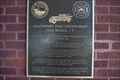 view gallery view gallerySE19.2 km | 1922 Ford Fire Truck - 1st Motorized Southport Fire Truck - Southport, NC in First of its Kind First motorized fire truck for Southport Fire Department and for Brunswick County. posted by: NCDaywalker location: North Carolina date approved: 08/31/2016 last visited: 02/26/2019 |
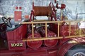 view gallery view gallerySE19.2 km | 1922 Ford Fire Truck - 1st Motorized Southport Fire Truck - Southport, NC in Fire Fighting Vehicles First motorized fire truck for Southport Fire Department and for Brunswick County. posted by: NCDaywalker location: North Carolina date approved: 08/31/2016 last visited: 02/26/2019 |
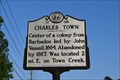 view gallery view galleryNE19.6 km | D-48 Charles Town in North Carolina Historical Markers Marker Text:
"Center of a colony from Barbados led by John Vassall, 1664. Abandoned by 1667. Was located 2 mi. E. on Town Creek." posted by: NCDaywalker location: North Carolina date approved: 05/15/2017 last visited: 05/15/2017 |
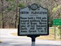 view gallery view galleryE19.8 km | Orton Plantation-D-53 in North Carolina Historical Markers Marker is in Winnabow, North Carolina, in Brunswick County. Marker is at the intersection of Plantation Road and Orton Road, on the left when traveling south on Plantation Road. posted by: Countrydragon location: North Carolina date approved: 12/17/2009 last visited: 02/22/2018 |
 view gallery view galleryE20 km | Brunswick-D54 in North Carolina Historical Markers Marker is near Winnabow, North Carolina, in Brunswick County. Marker is on Plantation Road near Orton Road, on the left when traveling south. posted by: Countrydragon location: North Carolina date approved: 12/17/2009 last visited: 08/20/2016 |
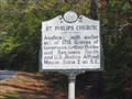 view gallery view galleryE20 km | St. Philips Church-D-55 in North Carolina Historical Markers Marker is near Winnabow, North Carolina, in Brunswick County. Marker is at the intersection of Plantation Road and Orton Road, on the left when traveling south on Plantation Road posted by: Countrydragon location: North Carolina date approved: 12/17/2009 last visited: 02/16/2023 |
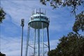
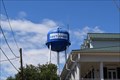 view gallery view gallerySE20 km | Southport Water Tower - Southport, NC, USA in Water Towers Located in the heart of town, is can be readily seen along Howe Street. posted by: NCDaywalker location: North Carolina date approved: 08/21/2016 last visited: 03/09/2017 |
 view gallery view gallerySE20 km |  DD2480 - SOUTHPORT MUNICIPAL TANK DD2480 - SOUTHPORT MUNICIPAL TANK
in U.S. Benchmarks Located in the heart of town, is can be seen for miles. posted by: ChapterhouseInc location: North Carolina date approved: 04/28/2010 last visited: 03/09/2017 |
|