 view gallery view gallery E9.2 km E9.2 km
|   Camp Coxcomb - Twentynine Palms, CA Camp Coxcomb - Twentynine Palms, CA
in Military Installations A former desert camp from WWII. posted by:  saopaulo1 saopaulo1 location: California date approved: 03/09/2020 last visited: never |
 view gallery view galleryE9.2 km |  Coxcomb Divisional Camp - Riverside County CA Coxcomb Divisional Camp - Riverside County CA
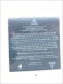
in E Clampus Vitus Historical Markers This E Clampus Vitus Historical Marker is on Hwy 177 about 10 miles south of Hwy 62 in Riverside County, California. posted by: PeterNoG location: California date approved: 02/26/2011 last visited: 12/26/2010 |
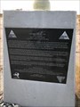
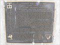
 view gallery view galleryE9.2 km | Palen Pass - Twentynine Palms, CA in E Clampus Vitus Historical Markers A plaque about the Palen Pass nd the operations during WWII. posted by: saopaulo1 location: California date approved: 03/09/2020 last visited: never |
 view gallery view galleryE9.2 km | Palen Maneuver Area - Twentynine Palms, CA in Military Installations A plaque about the Palen Pass nd the operations during WWII. posted by: saopaulo1 location: California date approved: 03/09/2020 last visited: never |
 view gallery view gallery NE23.8 km NE23.8 km
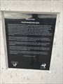
| Iron Mountain Divisional Camp - Rice, CA in Military Installations A desert camp used during WWII. posted by: saopaulo1 location: California date approved: 03/09/2020 last visited: never |
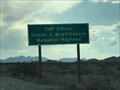 view gallery view galleryNE23.8 km |  Daniel J Muehlhausen Memorial Highway - Rice, CA Daniel J Muehlhausen Memorial Highway - Rice, CA
in Police Memorials A highway dedicated to Daniel J Muehlhausen. posted by: saopaulo1 location: California date approved: 03/11/2020 last visited: never |
 view gallery view galleryNE24.9 km | Camp Granite - Rice, CA in Military Installations A desert camp used during WWII. posted by: saopaulo1 location: California date approved: 03/09/2020 last visited: never |
 view gallery view galleryNE25.1 km | Granite Divisional Camp - San Bernardino County CA in E Clampus Vitus Historical Markers This E Clampus Vitus Historical Marker is on Hwy 62 about 5.5 miles east of Hwy 177 in San Bernardino County, California. posted by: PeterNoG location: California date approved: 02/21/2011 last visited: 11/27/2018 |
 view gallery view gallery S25.3 km S25.3 km
|  Desert Center Rod - Desert Center, CA Desert Center Rod - Desert Center, CA
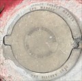
in U.S. Benchmarks A benchmark in Desert Center. posted by: bluesnote location: California date approved: 06/19/2018 last visited: 06/19/2018 |
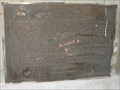
![Image for Iron Mountain Divisional Camp [Missing]](https://img.geocaching.com/waymarking/small/8d035feb-50c2-47ce-941c-cf5bac441fc5.jpg) view gallery view galleryNE25.4 km | Iron Mountain Divisional Camp [Missing] in E Clampus Vitus Historical Markers Marker is on Desert Center - Rice Road (California Route 62 at milepost 90.7), on the left when traveling east. Note: This marker and its companion across the road are now missing. The bare monuments are still present. posted by:  leadhiker leadhiker location: California date approved: 06/22/2011 last visited: 10/27/2015 |
 view gallery view galleryS25.4 km |  Desert Center, California Desert Center, California
in Wikipedia Entries A small town about halfway between Phoenix and Los Angeles. The above coordinates are for the post office. posted by: bluesnote location: California date approved: 06/18/2018 last visited: 06/18/2018 |
 view gallery view galleryS25.4 km |  Desert Center, CA 92239 Desert Center, CA 92239
in U.S. Post Offices Its hot in Desert Center! posted by: BackPak location: California date approved: 09/02/2007 last visited: 06/17/2018 |
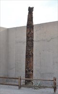
 view gallery view galleryS25.4 km |  992 SITE OF CONTRACTOR'S GENERAL HOSPITAL 992 SITE OF CONTRACTOR'S GENERAL HOSPITAL
in California Historical Markers Large rock and HOT on a summer day! posted by: BackPak location: California date approved: 09/08/2007 last visited: 06/17/2018 |
 view gallery view galleryS25.4 km |  Desert Center Animal Totem Pole Desert Center Animal Totem Pole
in Outside Wooden Display Carvings This Outside Wooden Display Carving stands at the east end of the historic Desert Center Café, the town's last surviving business, located at 44321 Ragsdale Road in Desert Center, California. posted by: brwhiz location: California date approved: 08/24/2013 last visited: 06/17/2018 |
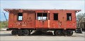 view gallery view galleryS25.4 km |  Kaiser Steel Caboose 1985 Kaiser Steel Caboose 1985
in Train Cabooses This Caboose is located just east of the Desert Center Cafe at 44321 Ragsdale Road in Desert Center, California. posted by: brwhiz location: California date approved: 08/26/2013 last visited: 06/17/2018 |
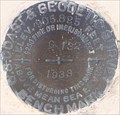 view gallery view galleryS25.4 km | U.S. Coast & Geodedtic Survey G 132 Benchmark - Desert Center, CA in U.S. Benchmarks A benchmark in Desert Center. posted by: bluesnote location: California date approved: 06/19/2018 last visited: 06/19/2018 |
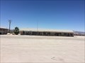
 view gallery view galleryS25.4 km |  Desert Center Cafe - Desert Center, CA Desert Center Cafe - Desert Center, CA
in Independent Diners The Desert Center Cafe in Desert Center, CA. posted by: bluesnote location: California date approved: 06/24/2018 last visited: 06/24/2018 |
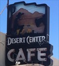 view gallery view galleryS25.4 km |  Desert Center Cafe - Desert Center, CA Desert Center Cafe - Desert Center, CA
in Neon Signs The Desert Center Cafe in Desert Center, CA. posted by: bluesnote location: California date approved: 06/18/2018 last visited: 06/18/2018 |
 view gallery view galleryS25.6 km |  Solar Pole - Desert Center, CA Solar Pole - Desert Center, CA
in Solar Power A solar powered pole in Desert Center. posted by: bluesnote location: California date approved: 06/18/2018 last visited: 06/18/2018 |
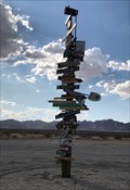
 view gallery view galleryNE27.7 km |  Homemade Arrow Sign near Twentynine Palms, CA Homemade Arrow Sign near Twentynine Palms, CA
in Direction and Distance Arrows This is a an arrow signpost at the junction of CA Hwy 177 and Iron Mountain PP Road Twentynine Palms. posted by: Poehunters location: California date approved: 08/13/2013 last visited: 04/22/2022 |
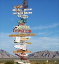
 view gallery view galleryNE27.7 km |  Desert Signpost - Twentynine Palms, CA Desert Signpost - Twentynine Palms, CA
in Roadside Attractions A sign post in the middle of the desert. posted by: saopaulo1 location: California date approved: 03/11/2020 last visited: 04/22/2022 |
 view gallery view gallery W45.7 km W45.7 km
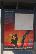
|  Turkey Flats Trailhead - Joshua Tree National Park Turkey Flats Trailhead - Joshua Tree National Park
in Hiking and walking trailheads This is the trailhead for the Turkey Flat trail located in the Joshua Tree National Park. This trail is a loop trail that leads up to the summit of Pinto Mountain and back again. posted by: geobwong2k location: California date approved: 03/25/2009 last visited: 01/03/2014 |
 view gallery view gallery SW46.5 km SW46.5 km
|  Antiques - Chiriaco Summit, CA Antiques - Chiriaco Summit, CA
in Antique Shops An antique store in Chiriaco Summit. posted by: bluesnote location: California date approved: 07/06/2018 last visited: 07/06/2018 |
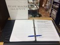 view gallery view gallerySW46.5 km |  Southwest Travel Information Center Guest Book - Chiriaco Summit, CA Southwest Travel Information Center Guest Book - Chiriaco Summit, CA
in Guest Books An information center in Chiriaco Summit. posted by: bluesnote location: California date approved: 06/21/2018 last visited: 06/21/2018 |
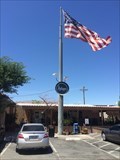
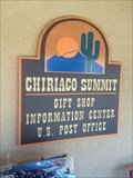 view gallery view gallerySW46.5 km |  Southwest Travel Information Center - Chiriaco Summit, CA Southwest Travel Information Center - Chiriaco Summit, CA
in Tourist Information Centers - Visitor Centers An information center in Chiriaco Summit. posted by: bluesnote location: California date approved: 06/21/2018 last visited: 06/21/2018 |
|