 view gallery view gallery N0.8 km N0.8 km
|   Confederate Battery Position - GHM 060-196 - Fulton Co., GA Confederate Battery Position - GHM 060-196 - Fulton Co., GA
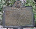
in Georgia Historical Markers This battery was one of several cavarly outpost maintained by Wheeler's Cavalery (CSA) to watch the ferries and fords along the Chattahoochee River in 1864. posted by:  Lat34North Lat34North location: Georgia date approved: 10/06/2007 last visited: 10/06/2007 |
 view gallery view gallery NE1 km NE1 km
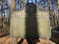
| Isom's Ferry - GHM 060-8 – Fulton Co., GA in Georgia Historical Markers ISOM'S FERRY - Chattahoochee River, at mouth of Soap Cr., .75 mi. N.W., operated in the 1860's by James Isom. posted by: Lat34North location: Georgia date approved: 07/28/2007 last visited: 10/31/2000 |
 view gallery view gallery S1.1 km S1.1 km
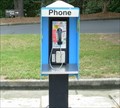
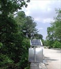
|  Payhone at BP station Northside Drive and Powers Ferry Payhone at BP station Northside Drive and Powers Ferry
in Payphones Bp Station Northside Drive and Powers Ferry Atlanta, Georgia posted by: Sprinterman location: Georgia date approved: 10/11/2007 last visited: 10/09/2007 |
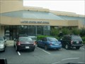
 view gallery view galleryS1.3 km |  Subway - Powers Ferry Road - Atlanta, GA Subway - Powers Ferry Road - Atlanta, GA
in Subway Restaurants This subway is located in a strip mall on Powers Ferry Road at Northside Dr., Atlanta, GA. posted by: Lat34North location: Georgia date approved: 05/31/2011 last visited: 05/28/2011 |
 view gallery view gallery SE1.6 km SE1.6 km
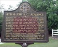
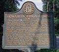
| 4th & 23d A.C. Advance - GHM 060-15 - Sandy Springs, Fulton Co., Ga. in Georgia Historical Markers Howard’s 4th A.C. was aligned along this ridge (Mt. Veron Rd.) with Hascall’s div. (23d A.C.) entrenched on Howard’s left. July 14 - July 17 1864 posted by: Lat34North location: Georgia date approved: 07/11/2007 last visited: 10/31/2000 |
 view gallery view gallerySE1.8 km | Crossroads of Destiny - Sandy Springs, GA in Georgia Historical Markers The Crossroads of Destiny tells the history of the area. The marker is located is front of the Mount Vernon Baptist Church, 850 Mt Vernon Hwy, Sandy Springs, GA. posted by: Lat34North location: Georgia date approved: 10/14/2013 last visited: 10/03/2013 |
 view gallery view galleryS1.9 km | Howard's 4th A.C. Line - GHM 060-14 - Fulton Co., GA in Georgia Historical Markers Howard's 4th A.C. - These troops [US] having crossed the river at & near Power’s Ferry July 12, 13, 1864, occupied an inerenched line on this ridge facing S.E. until the 18th ~ the rt. resting on the river, the left near Crossroads Church. posted by: Lat34North location: Georgia date approved: 08/25/2007 last visited: 10/31/2000 |
 view gallery view gallery SW1.9 km SW1.9 km
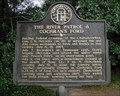
| The River Patrol & Cochran's Ford - GHM 033-89 - Cobb Co. Ga in Georgia Historical Markers Pending Federal crossings of the Chattahoochee, Gen. E. M. McCook's cav. div. [US] screened 4th and 23d Corps movements to fords and ferries in this vicinity, July 6, 15, 1864.
posted by: Lat34North location: Georgia date approved: 07/13/2007 last visited: 09/11/2008 |
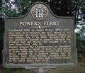 view gallery view gallerySW1.9 km | POWER'S FERRY - GHM 033-90 - Cobb, Co. Ga. in Georgia Historical Markers Power's Ferry - Established 1835 by James Power, (1790-1870). Maj. Gen. O. O. Howard's 4th A. C. (Army of the Cumberland) moves through the area in route to Atlanta. posted by: Lat34North location: Georgia date approved: 07/13/2007 last visited: 09/11/2008 |
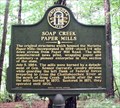 view gallery view galleryN2.6 km | Soap Creek Paper Mills - 033-91 - Cobb Co., Ga in Georgia Historical Markers The original structures which housed the Marietta Paper Mills incorporated in 1859 stood 1/4 mile down stream from Paper Mill Road. posted by: Lat34North location: Georgia date approved: 07/13/2007 last visited: 03/14/2009 |
 view gallery view gallery NW2.7 km NW2.7 km
| The 23d Corps at Soap Creek - GHM 033-92 - Marietta, GA in Georgia Historical Markers Located in Chattahoochee River NRA parking area.
There is a nearly duplicate marker located a few steps from this marker. posted by:  Markerman62 Markerman62 location: Georgia date approved: 05/01/2023 last visited: never |
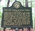 view gallery view galleryNW2.9 km | The 23d Corps at Soap Creek - 033-92 - Cobb Co., Ga. in Georgia Historical Markers July 8, 1864, The first passage of the Chattahoochee River by Federal forces was made at month of Soap Creek by Cox’s division, 23d A.C. posted by: Lat34North location: Georgia date approved: 07/13/2007 last visited: 07/31/2000 |
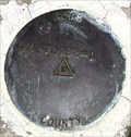
 view gallery view galleryN2.9 km |  BM171077-1 - Paper Mill Rd - Marietta, GA BM171077-1 - Paper Mill Rd - Marietta, GA
in U.S. Benchmarks Located on the north east end of the bridge abutment at Soap Creek on Paper Mill Rd, Marietta, GA. posted by: Lat34North location: Georgia date approved: 12/15/2009 last visited: 09/06/2009 |
 view gallery view gallery E3.1 km E3.1 km
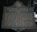
| To Sandy Springs & Old Cross Keys - GHM 060-9 - Fulton Co. in Georgia Historical Markers Schofield’s 23d A.C. the fist of the Federal forces to cross the river [Chattahoochee], remained on this ridge [Mt Vernon Rd] from July 8 to 17, 1864. posted by: Lat34North location: Georgia date approved: 07/11/2007 last visited: 10/31/2000 |
 view gallery view gallery W3.2 km W3.2 km
|  Osborn Cemetery - Powers Ferry Rd. - Marietta, GA. Osborn Cemetery - Powers Ferry Rd. - Marietta, GA.
in Worldwide Cemeteries The Osborn Cemetery is located on Powers Ferry Rd. in Marietta, GA. This is a small cemetery with between 80 and 100 graves. posted by: Lat34North location: Georgia date approved: 11/17/2009 last visited: 11/15/2009 |
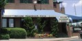 view gallery view galleryW3.4 km |  Mellow Mushroom Pizza - Powers Ferry Road - Marietta, GA Mellow Mushroom Pizza - Powers Ferry Road - Marietta, GA
in Pizza Shops - Regional Chains This Mellow Mushroom Pizza is located in a mixed usage building located at the intersection of Powers Ferry Road and Windy Hill Rd, Marietta, GA. posted by: Lat34North location: Georgia date approved: 06/20/2010 last visited: 06/20/2010 |
 view gallery view galleryW3.4 km |  Quiznos Subs - Powers Ferry Road - Marietta, GA Quiznos Subs - Powers Ferry Road - Marietta, GA
in Quiznos This Quiznos Subs is located in a mixed usage building located at the intersection of Powers Ferry Road and Windy Hill Rd, Marietta, GA. posted by: Lat34North location: Georgia date approved: 06/20/2010 last visited: 06/20/2010 |
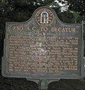 view gallery view galleryE3.4 km | 23d A.C. to Decatur - GHM 060-10 - Sandy Springs, Fulton Co., Ga in Georgia Historical Markers Schofield’s 23d A.C. leaves its river positions near Isom’s ferry on the Chattahoochee River to begin its march to Decatur Ga. posted by: Lat34North location: Georgia date approved: 07/11/2007 last visited: 10/31/2000 |
 view gallery view galleryE3.4 km | Arlington Memorial Park - Sandy Springs, GA in Worldwide Cemeteries Arlington Memorial Park located in Sandy Springs, Fulton Co., GA. posted by: Lat34North location: Georgia date approved: 08/12/2007 last visited: 02/03/2016 |
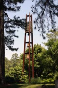 view gallery view galleryE3.4 km |  Arlington Memorial Park – Sandy Springs, GA Arlington Memorial Park – Sandy Springs, GA
in Bell Towers Bell tower located along the entrace drive at the Arlington Memorial Cemetery in Sandy Springs, GA. posted by: Lat34North location: Georgia date approved: 06/02/2009 last visited: 06/01/2009 |
 view gallery view galleryW3.4 km |  McDonald's - Powers Ferry Rd. - Marietta, GA McDonald's - Powers Ferry Rd. - Marietta, GA
in Wi-Fi Hotspots McDonald's located on Powers Ferry Rd, near the Powers Ferry shopping center, Marietta, GA. posted by: Lat34North location: Georgia date approved: 11/17/2009 last visited: 11/15/2009 |
 view gallery view galleryW3.4 km |  McDonald's - Powers Ferry Rd - Marietta, GA McDonald's - Powers Ferry Rd - Marietta, GA
in McDonald's Restaurants McDonald's located on Powers Ferry Rd, near the Powers Ferry shopping center, Marietta, GA. posted by: Lat34North location: Georgia date approved: 11/17/2009 last visited: 10/05/2012 |
 view gallery view gallerySW3.5 km |  Rottenwood Creek (Interstate N Pkwy) Smyrna, GA, USGS 02335910 Rottenwood Creek (Interstate N Pkwy) Smyrna, GA, USGS 02335910
in River Gauges Located on the foot bridge over Rottonwood Creek south of the parking area for the Bob Callan Trail on Interstate N. Parkway. posted by: Lat34North location: Georgia date approved: 05/08/2008 last visited: 05/07/2008 |
 view gallery view gallerySW3.5 km | Interstate N Parkway, Cobb Co., GA – BM 170982-1 in U.S. Benchmarks Located on the north east abutment of the bridge over Rottenwood Creek on Interstate N Parkway in Cobb Co. posted by: Lat34North location: Georgia date approved: 05/14/2008 last visited: 09/07/2007 |
 view gallery view galleryW3.5 km |  Marietta, Georgia 30067 (Windy Hill Branch) Marietta, Georgia 30067 (Windy Hill Branch)
in U.S. Post Offices Marietta, Georgia, Windy Hill Branch posted by: Sprinterman location: Georgia date approved: 10/05/2007 last visited: 10/04/2007 |
|