 view gallery view gallery SE4.2 km SE4.2 km
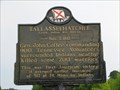
|   Tallasseehatchee Tallasseehatchee
in Alabama Historical Markers Tallasseehatchee
Creek Indian War 1813-14, November 3, 1813. General John Coffee, commanding 900 Tennessee Volunteers, surrounded the Indians nearby and killed some 200 warriors. This was the first American victory of the war. It avenged the earlier massacre of 517 at Ft. Mims by Indians.
posted by:  Thorny1 Thorny1 location: Alabama date approved: 07/03/2008 last visited: 08/15/2012 |
 view gallery view gallery S6 km S6 km
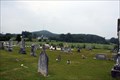
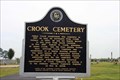
|  Crook Cemetery - Alexandria, AL Crook Cemetery - Alexandria, AL
in Worldwide Cemeteries James Crook established this cemetery in 1837 on land he purchased from Creek Indian. Located at the cemetery on McCullars Lane west of County Road 73, Alexandria, Alabama. posted by: Lat34North location: Alabama date approved: 08/20/2012 last visited: 08/15/2012 |
 view gallery view galleryS6 km | Crook Cemetery - Alexandria, AL in Alabama Historical Markers James Crook established this cemetery in 1837 on land he purchased from Creek Indian. Located at the cemetery on McCullars Lane west of County Road 73, Alexandria, Alabama. posted by: Lat34North location: Alabama date approved: 08/17/2012 last visited: 08/15/2012 |
 view gallery view galleryS6 km | Lincoyer and The Battle of Tallasehatchee - Alexandria, Alabama in Alabama Historical Markers Site where Lincoyer was found and saved by Gen. Andrew Jackson after the Battle of Talluschatches. Located on McCullars Lane west of County Road 73, Alexandria, Alabama. posted by: Lat34North location: Alabama date approved: 08/19/2012 last visited: 08/15/2012 |
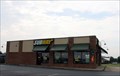 view gallery view gallerySE8.5 km |  Subway # 28783 - US 431 - Alexanderia, AL Subway # 28783 - US 431 - Alexanderia, AL
in Subway Restaurants This free standing subway is located on U.S. 431, Alexandria, AL. posted by: Lat34North location: Alabama date approved: 08/17/2012 last visited: 08/15/2012 |
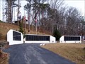 view gallery view gallery SW8.9 km SW8.9 km
|  Calhoun County Confederate Memorial - Ohatchee, AL Calhoun County Confederate Memorial - Ohatchee, AL
in American Civil War Monuments and Memorials The Calhoun County Confederate Memorial is located at Janney Furnace Confederate Park on Janney Road. posted by:  hummerstation hummerstation location: Alabama date approved: 02/11/2013 last visited: never |
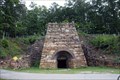 view gallery view gallerySW9 km |  Janney Furnace - Ohatchee, Alabama Janney Furnace - Ohatchee, Alabama
in Iron Furnace Ruins The furnace was constructed by Montgomery businessman Alfred A. Janney. Located on Janney Road 0.1 miles east of Spring Road, Ohatchee, Alabama. posted by: Lat34North location: Alabama date approved: 08/29/2012 last visited: 01/08/2013 |
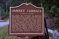 view gallery view gallerySW9 km | Janney Furnace - Ohatchee, Alabama in Alabama Historical Markers The furnace was constructed by Montgomery businessman Alfred A. Janney. Located on Janney Road 0.1 miles east of Spring Road, Ohatchee, Alabama' posted by: Lat34North location: Alabama date approved: 08/21/2012 last visited: 01/08/2013 |
 view gallery view gallery NW11.9 km NW11.9 km
| Subway # 32480 - AL 77 - Gadsden, AL in Subway Restaurants This Subway is located on Alabama Highway 77 in (Southside) Gadsden, AL. posted by: Lat34North location: Alabama date approved: 08/22/2012 last visited: 08/15/2012 |
 view gallery view galleryNW12.6 km |  McDonald's - Grub Mart - AL 77 - Gadsden, AL McDonald's - Grub Mart - AL 77 - Gadsden, AL
in Wi-Fi Hotspots This McDonald's is co-located with the Grub Mart on Alabama State Road 77 in Gadsden, AL. posted by: Lat34North location: Alabama date approved: 08/23/2012 last visited: 08/15/2012 |
 view gallery view galleryNW12.6 km |  McDonald's - Grub Mart - AL 77 - Gadsden, AL McDonald's - Grub Mart - AL 77 - Gadsden, AL
in McDonald's Restaurants This McDonald's is co-located with the Grub Mart on Alabama State Road 77 in Gadsden, AL. posted by: Lat34North location: Alabama date approved: 08/24/2012 last visited: 08/15/2012 |
 view gallery view gallerySE12.9 km | Major John Pelham in Alabama Historical Markers Major John Pelham was born here Sept 7, 1838 posted by: Thorny1 location: Alabama date approved: 07/03/2008 last visited: 08/15/2012 |
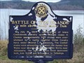 view gallery view gallerySW13 km | Battle of "Ten Islands" - Ohatchee, AL in Alabama Historical Markers The Battle of "Ten Islands" historical marker commemorates a July 14, 1864 Civil War battle. posted by: hummerstation location: Alabama date approved: 01/10/2013 last visited: never |
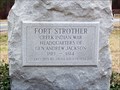 view gallery view gallerySW13.2 km | Fort Strother - Ohatchee, AL in Alabama Historical Markers Fort Strother was the Creek Indian War Headquarters of Gen. Andrew Jackson. posted by: hummerstation location: Alabama date approved: 01/10/2013 last visited: never |
 view gallery view gallery E15.3 km E15.3 km
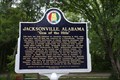
| Jacksonville, Alabama “Gem of the Hills” - Jacksonville, Alabama in Alabama Historical Markers History of Jacksonville, AL, which was purchased from Creek Indian Chief Ladiga in 1833. Located at the old train depot, on Mountain Street Northwest west of Woodward Avenue Northwest, Jacksonville, Alabama. posted by: Lat34North location: Alabama date approved: 08/28/2012 last visited: 01/11/2022 |
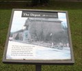 view gallery view galleryE15.3 km | The Depot Chief Ladiga Trail - Jacksonville, AL in Alabama Historical Markers The Depot was constructed in 1860 by the Selma, Rome and Dalton (GA) Railroad. Located at the old train depot, on Mountain Street Northwest west of Woodward Avenue Northwest, Jacksonville, Alabama. posted by: Lat34North location: Alabama date approved: 08/29/2012 last visited: 01/11/2022 |
 view gallery view galleryE15.3 km | Chief Ladiga Trail - Jacksonville, AL in Alabama Historical Markers Located on the Chief Ladiga Trail (walking path) on Mountain Street Northwest west of Woodward Avenue Northwest, Jacksonville, Alabama. posted by: Lat34North location: Alabama date approved: 08/29/2012 last visited: 01/11/2022 |
 view gallery view galleryE15.3 km |  Jacksonville, AL Jacksonville, AL
in Train Stations/Depots The Jacksonville, AL, depot was built in 1860. Located on the Chief Ladiga Trail (walking path) on Mountain Street Northwest west of Woodward Avenue Northwest, Jacksonville, Alabama. posted by: Lat34North location: Alabama date approved: 08/28/2012 last visited: 08/15/2012 |
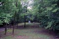
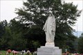 view gallery view galleryE15.3 km | Jacksonville State University Cemetery - Nisbet Street - Jacksonville, AL in Worldwide Cemeteries This fairly large cemetery is located on the campus of Jacksonville State University and has well over 1,000 headstones. It is located on Nisbet Street (Rout 204) near Park Ave, Jacksonville, AL. posted by: Lat34North location: Alabama date approved: 08/28/2012 last visited: 08/15/2012 |
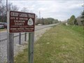
 view gallery view gallerySE15.4 km |  Anniston, Alabama - Chief Ladiga Trail. Anniston, Alabama - Chief Ladiga Trail.
in Rails to Trails The Chief Ladiga Trail wanders 33 miles from Anniston North East through Alabama. Eventually the Silver Comet Trail, which will start in Smyrna, Georgia and end in Cedartown, Georgia, will connect with the Chief Ladiga at the Alabama/Georgia State line creating a 90-mile continuous trail. posted by: clevortrevor location: Alabama date approved: 03/31/2006 last visited: 12/03/2011 |
 view gallery view gallerySE15.4 km |  Anniston, Alabama - Chief Ladiga Trail. Anniston, Alabama - Chief Ladiga Trail.
in Mountain Bike Trailheads The Chief Ladiga Trail wanders 33 miles North East through Alabama. Eventually the Silver Comet Trail, which will start in Smyrna, Georgia and end in Cedartown, Georgia, will connect with the Chief Ladiga at the Alabama/Georgia State line creating a 90-mile continuous trail. posted by: clevortrevor location: Alabama date approved: 03/31/2006 last visited: 12/03/2011 |
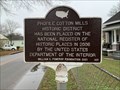 view gallery view galleryE15.6 km | Profile Cotton Mills Historic District - Jacksonville, AL in Alabama Historical Markers Located in A Street SW at G Ave SW, Jacksonville posted by: Markerman62 location: Alabama date approved: 03/30/2022 last visited: never |
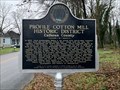 view gallery view galleryE15.9 km | Profile Cotton Mill Historic District ~ Calhoun County - Jacksonville, AL in Alabama Historical Markers Located on A Street SW and H Avenue SW, Jacksonville posted by: Markerman62 location: Alabama date approved: 03/30/2022 last visited: never |
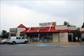
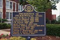 view gallery view galleryE15.9 km | Presidents of Jacksonville State - Jacksonville, AL in Alabama Historical Markers This marker list the Presidents of Jacksonville State from James G. Ryals, Jr. 1883-1885 to William A. Meehan 1999. Located on University Circle west of North Pelham Road (State Highway 21), Jacksonville, Alabama. posted by: Lat34North location: Alabama date approved: 08/23/2012 last visited: 01/11/2022 |
 view gallery view galleryE15.9 km | Jacksonville State University - Jacksonville, AL in Alabama Historical Markers Traces the origin of the Jacksonville State University. Located on University Circle west of North Pelham Road (State Highway 21), Jacksonville, Alabama. posted by: Lat34North location: Alabama date approved: 08/23/2012 last visited: 01/11/2022 |
|