 view gallery view gallery S7.7 km S7.7 km
|   Cactus City Eastbound Rest Area Cactus City Eastbound Rest Area
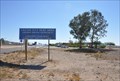
in Highway Rest Areas The Cactus City Westbound Rest Area is located on the north side of Interstate Highway 10 about 14 miles west of Chiriaco Summit, California. posted by:  brwhiz brwhiz location: California date approved: 12/09/2012 last visited: 01/07/2013 |
 view gallery view galleryS7.7 km | Cactus City Westbound Rest Area in Highway Rest Areas The Cactus City Westbound Rest Area is located on the north side of Interstate Highway 10 about 14 miles west of Chiriaco Summit, California. posted by: brwhiz location: California date approved: 12/09/2012 last visited: 03/25/2014 |
 view gallery view galleryS7.7 km |  Desert Tortoise Desert Tortoise
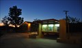
in Flora and Fauna Information Signs This Flora and Fauna Information Sign is one of several in the Cactus City Eastbound Rest Area on the south side of Interstate Highway 10 about 12 miles east of Indio, California. posted by: brwhiz location: California date approved: 12/14/2012 last visited: 01/07/2013 |
 view gallery view gallery SE10.8 km SE10.8 km
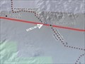
|  Pinkham Canyon Trail - Cactus City CA Pinkham Canyon Trail - Cactus City CA
in Offroad Trails This Offroad Trail begins at Exit 162 of I-10 near Cactus City, California. posted by: PeterNoG location: California date approved: 01/08/2013 last visited: 03/25/2014 |
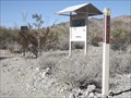
 view gallery view gallerySE10.8 km |  You are here at Pinkham Canyon Trail - Cactus City CA You are here at Pinkham Canyon Trail - Cactus City CA
in 'You Are Here' Maps This 'You Are Here' Map is at the trailhead for the Pinkham Canyon Trail at Exit 162 of I-10 near Cactus City, California. posted by: PeterNoG location: California date approved: 01/08/2013 last visited: 03/25/2014 |
 view gallery view gallery W10.9 km W10.9 km
|  DX0643: T5S R8E SECS 11 12 13 14 - Coachella CA DX0643: T5S R8E SECS 11 12 13 14 - Coachella CA
in U.S. Benchmarks This Benchmark is 45 feet southeast of Fargo Canyon Road about 0.32 miles east of Old Aquaduct Road near Coachella, California. posted by: PeterNoG location: California date approved: 09/22/2013 last visited: 03/29/2009 |
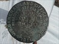 view gallery view galleryW10.9 km |  T5S R8E SECS 11 12 13 14 COR - Coachella CA T5S R8E SECS 11 12 13 14 COR - Coachella CA
in Public Land Survey Marks This Public Land Survey Mark is 45 feet southeast of Fargo Canyon Road about 0.32 miles east of Old Aquaduct Road near Coachella, California. posted by: PeterNoG location: California date approved: 09/22/2013 last visited: 03/29/2009 |
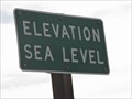 view gallery view galleryW15.3 km |  Elevation Sea Level - I-10 eastbound - Coachella CA Elevation Sea Level - I-10 eastbound - Coachella CA
in Elevation Signs The elevation sign is on eastbound I-10 about 1 mile east of Dillon Rd in Coachella, California. posted by: PeterNoG location: California date approved: 01/31/2011 last visited: 01/07/2013 |
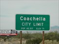 view gallery view galleryW15.3 km | Coachella CA - 71 ft - I 10 in Elevation Signs This elevation/population sign for Coachella, California is on the westbound I-10 freeway 1 mile east of Dillon Rd. posted by: PeterNoG location: California date approved: 01/31/2011 last visited: 09/28/2011 |
 view gallery view galleryW15.3 km |  Coachella CA - 40,517 - I 10 Coachella CA - 40,517 - I 10
in Population Signs This population/elevation sign for Coachella, California is on the westbound I-10 freeway 1 mile east of Dillon Rd. posted by: PeterNoG location: California date approved: 02/01/2011 last visited: 01/07/2013 |
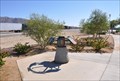
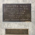 view gallery view gallerySE15.6 km |  Shaver's Well - near Mecca, CA Shaver's Well - near Mecca, CA
in E Clampus Vitus Historical Markers This marker consists of a couple of plaques embedded in a concrete monolith. The monolith stands fairly far off the road. CAUTION: terrain is soft, if you don't have 4WD or AWD or at least limited slip, you'll get stuck. posted by: QuesterMark location: California date approved: 03/09/2019 last visited: 03/10/2019 |
 view gallery view gallery E15.6 km E15.6 km
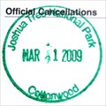
|  Joshua Tree National Park Cottonwood Visitor Center Joshua Tree National Park Cottonwood Visitor Center
in NPS Passport Cancellation Stations The cancellation stamp for Joshua Tree National Park Cottonwood Visitor Center. posted by: geobwong2k location: California date approved: 03/26/2009 last visited: 11/21/2018 |
 view gallery view galleryW16.6 km |  Carl's Jr. - Dillon Rd - Coachella CA Carl's Jr. - Dillon Rd - Coachella CA
in Carl's Jr./Hardee's Restaurants This Carl's Jr. is on Dillon Rd just north of the I-10 freeway in Coachella, California. posted by: PeterNoG location: California date approved: 02/01/2011 last visited: 01/11/2013 |
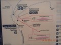 view gallery view galleryE16.9 km | Cottonwood Spring, Joshua Tree NP You Are Here sign in 'You Are Here' Maps You are here sign at the Cottonwood Spring trailhead. posted by: toponym location: California date approved: 04/11/2010 last visited: 01/03/2014 |
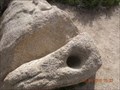 view gallery view galleryE17.1 km |  Cottonwood Spring bedrock mortars Cottonwood Spring bedrock mortars
in New World Ancient Evidence A single large rock with two mortar holes. posted by: toponym location: California date approved: 04/11/2010 last visited: never |
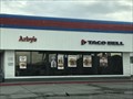 view gallery view galleryW17.1 km |  Arby's - Dillon Rd - Coachella, CA Arby's - Dillon Rd - Coachella, CA
in Arby's Restaurants An Arby's on Dillion in Coachella, CA. posted by: saopaulo1 location: California date approved: 09/24/2017 last visited: 08/03/2019 |
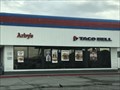 view gallery view galleryW17.1 km |  Taco Bell - Dillon Rd - Coachella, CA Taco Bell - Dillon Rd - Coachella, CA
in Taco Bell Restaurants A gas station Taco Bell on Dillion in Coachella, CA. posted by: saopaulo1 location: California date approved: 09/24/2017 last visited: 08/03/2019 |
 view gallery view gallery SW17.5 km SW17.5 km
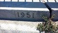
|  Airport Blvd Bridge - 1951 - Thermal, CA Airport Blvd Bridge - 1951 - Thermal, CA
in Bridge Date Stones and Plaques This dated bridge is located along Airport Blvd in Thermal, CA. posted by: NW_history_buff location: California date approved: 05/14/2014 last visited: never |
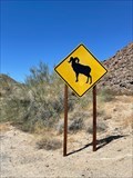 view gallery view galleryE17.5 km |  Bighorn Sheep- Joshua Tree S Entrance Bighorn Sheep- Joshua Tree S Entrance
in Uncommon Crossing Signs From the S entrance into Joshua Tree there is this very large Bighorn Sheep Crossing Sign. posted by:  funsigns funsigns location: California date approved: 04/19/2021 last visited: never |
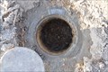 view gallery view gallerySW17.9 km | DX3685 ~ F1420 in U.S. Benchmarks This Vertical Control Mark is located next to the US Post Office located at 87200 Airport Blvd in Thermal, California. posted by: brwhiz location: California date approved: 08/03/2013 last visited: 03/26/2014 |
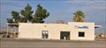 view gallery view gallerySW17.9 km |  Thermal, California 92274 ~ Main Post Office Thermal, California 92274 ~ Main Post Office
in U.S. Post Offices This Post Office is located at 87200 Airport Blvd in Thermal, California. posted by: brwhiz location: California date approved: 07/28/2013 last visited: 03/26/2014 |
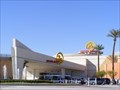 view gallery view galleryW17.9 km |  Spotlight 29 Casino - Coachella CA Spotlight 29 Casino - Coachella CA
in Wikipedia Entries Spotlight 29 Casino is an Indian casino at 46-200 Harrison Place, Coachella, California, 92236 owned and operated by the Twenty-Nine Palms Band of Mission Indians of California. posted by: Don.Morfe location: California date approved: 11/22/2023 last visited: 11/22/2023 |
 W17.9 km |  Trump 29 Casino Trump 29 Casino
in Casinos Trump29 Casino in Coachella Valley, CA posted by: nerofotia location: California date approved: 08/06/2007 last visited: 11/22/2023 |
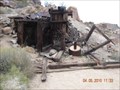 view gallery view galleryE18 km |  Mastodon Mine Mastodon Mine
in Mines One of several abandoned mines in Joshua Tree National Park. posted by: toponym location: California date approved: 04/12/2010 last visited: never |
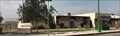 view gallery view gallerySW18 km |  Jerry Rummonds Memorial Community and Senior Center - Thermal, CA Jerry Rummonds Memorial Community and Senior Center - Thermal, CA
in Municipal Community Centers The Jerry Rummonds Memorial Community and Senior Center in Thermal, CA. posted by: saopaulo1 location: California date approved: 09/26/2017 last visited: never |
|