 view gallery view gallery W0.2 km W0.2 km
|   Altisima Park - Rancho Santa Margarita, CA Altisima Park - Rancho Santa Margarita, CA
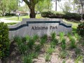
in Public Swimming Pools A large park in Rancho Santa Margarita, California. posted by:  bluesnote bluesnote location: California date approved: 07/09/2023 last visited: never |
 view gallery view galleryW0.3 km |  Altisima Park LFL - Rancho Santa Margarita, CA Altisima Park LFL - Rancho Santa Margarita, CA
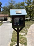
in Eagle Scout Project Sites A LFL at Altisima Park in Rancho Santa Margarita, California. posted by: bluesnote location: California date approved: 07/09/2023 last visited: never |
 view gallery view galleryW0.3 km |  Altisima Park LFL - Rancho Santa Margarita, CA Altisima Park LFL - Rancho Santa Margarita, CA
in Free Community Book Exchanges A LFL at Altisima Park in Rancho Santa Margarita, California. posted by: bluesnote location: California date approved: 07/09/2023 last visited: never |
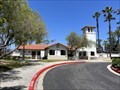
 view gallery view galleryW0.3 km |  Altisima Park - Rancho Santa Margarita, CA Altisima Park - Rancho Santa Margarita, CA
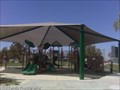
in Public Playgrounds Altisima Park playgound has a large UV shade cover over the swings and two play structures. There is also a community swimming pool, 2 baseball diamonds, basketball courts and tennis courts. You will need a SAMLARC key for the restrooms. posted by:  DopeyDuck DopeyDuck location: California date approved: 04/22/2009 last visited: 06/27/2014 |
 view gallery view galleryW0.3 km |  Altisima Park Baseball Fields - Rancho Santa Margarita, CA Altisima Park Baseball Fields - Rancho Santa Margarita, CA
in Amateur Baseball Fields Altisima Park has a pair of baseball fields that are next to each other. posted by: Gryffindor3 location: California date approved: 06/30/2009 last visited: 06/29/2014 |
 view gallery view galleryW0.3 km |  Altisima Park - Rancho Santa Margarita, CA Altisima Park - Rancho Santa Margarita, CA
in Municipal Parks and Plazas A large park in Rancho Santa Margarita, California. posted by: bluesnote location: California date approved: 04/02/2021 last visited: 04/02/2021 |
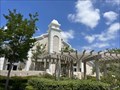 view gallery view gallery NW0.3 km NW0.3 km
|  Church of Jesus Christ of Latter-Day Saints - Rancho Santa Margarita, CA Church of Jesus Christ of Latter-Day Saints - Rancho Santa Margarita, CA
in Religious Buildings Multifarious An LDS church in Rancho Santa Margarita, California. posted by: bluesnote location: California date approved: 08/14/2023 last visited: never |
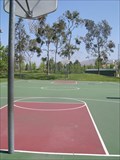 view gallery view galleryW0.3 km |  Altisima Park Basketball Court - Rancho Santa Margarita, CA Altisima Park Basketball Court - Rancho Santa Margarita, CA
in Outdoor Basketball Courts Altisima Park has a full sized basketball court for recreational use. posted by: Gryffindor3 location: California date approved: 07/13/2009 last visited: 06/29/2014 |
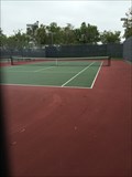 view gallery view galleryW0.3 km |  Altisima Park Tennis Facility - Rancho Santa Margarita, CA Altisima Park Tennis Facility - Rancho Santa Margarita, CA
in Tennis Facilities This is one of many tennis facilities in the area. posted by: bluesnote location: California date approved: 06/28/2014 last visited: 06/28/2014 |
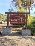 view gallery view galleryW0.8 km |  Camp Rotary - Mission Viejo, CA Camp Rotary - Mission Viejo, CA
in Rotary International Markers A camp sign at BSA Orange County Council's Oso Lake. posted by: bluesnote location: California date approved: 08/18/2018 last visited: 08/18/2018 |
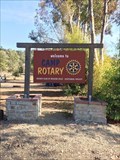 view gallery view galleryW0.8 km |  Camp Rotary - Mission Viejo, CA Camp Rotary - Mission Viejo, CA
in Freestanding Arches A camp sign at BSA Orange County Council's Oso Lake. posted by: bluesnote location: California date approved: 08/18/2018 last visited: 08/18/2018 |
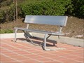 view gallery view galleryW0.8 km |  Bookcrossing Bench - Rancho Santa Margarita, CA Bookcrossing Bench - Rancho Santa Margarita, CA
in Bookcrossing Zones A solitary bench in Rancho Santa Margarita pulls double-duty: it's a nifty resting place *and* a bookcrossing zone. posted by: Gryffindor3 location: California date approved: 02/20/2009 last visited: 03/08/2009 |
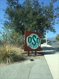
 view gallery view galleryNW0.8 km |  Oso Lake Boat Gardens - Mission Viejo, CA Oso Lake Boat Gardens - Mission Viejo, CA
in Landlocked Boats A series of boat gardens located at the ranger station at Oso Lake. posted by: bluesnote location: California date approved: 08/17/2018 last visited: 08/17/2018 |
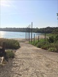 view gallery view galleryW0.8 km |  Oso Lake Boat Ramp - Mission Viejo, CA Oso Lake Boat Ramp - Mission Viejo, CA
in Boat Ramps A boat ramp used by rangers at Oso Lake. posted by: bluesnote location: California date approved: 08/20/2018 last visited: 08/20/2018 |
 view gallery view gallery NE1 km NE1 km
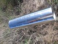
| Vista Point Eagle Scout Project in Eagle Scout Project Sites This Eagle Scout Project consists of metal tubes used as scopes pointing out the peaks and landmarks in this 360-degree view. This is 1 of 2 Eagle Scout Projects here. posted by: DopeyDuck location: California date approved: 07/21/2008 last visited: 01/07/2012 |
 view gallery view galleryNE1 km | Vista Point Orientation Table Eagle Scout Project in Eagle Scout Project Sites This Eagle Scout Project was built in 1993 and consists of an orientation table plaque pointing out the peaks, ridges and drainages for Saddleback Mountain. posted by: DopeyDuck location: California date approved: 07/25/2008 last visited: 01/07/2012 |
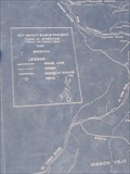
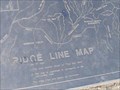 view gallery view galleryNE1 km |  Vista Point Ridge Line Map - Rancho Santa Margarita, CA Vista Point Ridge Line Map - Rancho Santa Margarita, CA
in Orientation Tables This orientation table is labeled Ridge Line Map and points out the peaks, ridges and drainages of Saddleback Mountain. posted by: DopeyDuck location: California date approved: 07/23/2008 last visited: 01/07/2012 |
 view gallery view galleryW1 km |  Oso Lake - Rancho Santa Margarita, CA Oso Lake - Rancho Santa Margarita, CA
in Campgrounds A scout camp located in Rancho Santa Margarita. posted by: bluesnote location: California date approved: 09/05/2018 last visited: 09/05/2018 |
 view gallery view galleryW1 km | Oso Lake - Rancho Santa Margarita, CA in Boy Scout Camps As the newest facility in the Orange County Council, Oso Lake offers camping, fishing, water conservation, and numerous other scout activities. posted by: Gryffindor3 location: California date approved: 02/22/2009 last visited: 08/17/2018 |
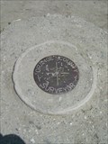 view gallery view galleryNE1 km |  DX4311 - Rancho Santa Margarita, CA DX4311 - Rancho Santa Margarita, CA
in U.S. Benchmarks This benchmark overlooks O'Neill Regional Park. posted by: Gryffindor3 location: California date approved: 05/15/2009 last visited: 01/07/2012 |
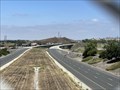 view gallery view gallery SW1.1 km SW1.1 km
|  California State Route 241 - Orange County, CA California State Route 241 - Orange County, CA
in Wikipedia Entries A toll road that is entirely within Orange County, California. The above coordinates are for where I took my photos, in Mission Viejo. posted by: bluesnote location: California date approved: 07/04/2023 last visited: never |
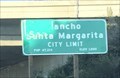 view gallery view gallerySW1.1 km |  Rancho Santa Margarita, California ~ Population 47,214 Rancho Santa Margarita, California ~ Population 47,214
in Population Signs An elevation / population sign along CA-Route 241. posted by: bluesnote location: California date approved: 02/25/2021 last visited: 02/25/2021 |
 view gallery view gallerySW1.1 km |  Rancho Santa Margarita, California ~ Elevation 1000 ft Rancho Santa Margarita, California ~ Elevation 1000 ft
in Elevation Signs An elevation / population sign along CA-Route 241. posted by: bluesnote location: California date approved: 02/25/2021 last visited: 02/25/2021 |
 view gallery view galleryNW1.1 km |  Live Oak Trail - Mission Viejo, CA Live Oak Trail - Mission Viejo, CA
in Hiking and walking trailheads A trailhead for Live Oak Trail in Mission Viejo, California. posted by: bluesnote location: California date approved: 02/20/2022 last visited: never |
 view gallery view galleryNW1.1 km |  Live Oak Trail - Mission Viejo, CA Live Oak Trail - Mission Viejo, CA
in Mountain Bike Trailheads A trailhead for Live Oak Trail in Mission Viejo, California. posted by: bluesnote location: California date approved: 02/20/2022 last visited: never |
|