 view gallery view gallery S0 km S0 km
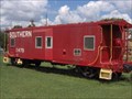
|   Southern Railroad Caboose X475, Langley, SC Southern Railroad Caboose X475, Langley, SC
in Train Cabooses Southern Railroad Caboose X475, Langley, South Carolina, USA. posted by:  tnt-tim tnt-tim location: South Carolina date approved: 09/23/2007 last visited: 01/16/2015 |
 view gallery view gallery NE0.3 km NE0.3 km
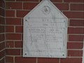
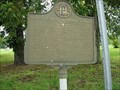
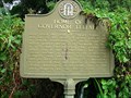
|  1956 - AFM cornerstone - Langley SC 1956 - AFM cornerstone - Langley SC
in Dated Buildings and Cornerstones cornerstone on the Free Mason building in Langley, SC posted by:  gpsblake gpsblake location: South Carolina date approved: 01/18/2015 last visited: never |
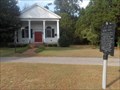
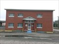 view gallery view galleryNE0.3 km |  Horse Creek Lodge #174 - Langley, SC Horse Creek Lodge #174 - Langley, SC
in Masonic Temples Horse Creek lodge #174 at the corner of Carline Ave and Depot Street in Langley, SC posted by: gpsblake location: South Carolina date approved: 01/17/2015 last visited: never |
![Image for Breeze Hill Municipal Tank [DE2377]](https://img.geocaching.com/waymarking/small/1ed4ce67-347a-4179-8af0-c19218427a45.jpg) view gallery view gallery N6.6 km N6.6 km
|  Breeze Hill Municipal Tank [DE2377] Breeze Hill Municipal Tank [DE2377]
in Water Towers Located in Breezy Hill, South Carolina. posted by: ChapterhouseInc location: South Carolina date approved: 10/16/2005 last visited: never |
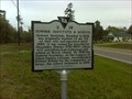
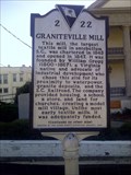 view gallery view galleryNE6.8 km |  2-22 Graniteville Mill 2-22 Graniteville Mill
in South Carolina Historical Markers This marker helps answer the question typically asked "What are all of these buildings? Why are they here in this quaint and quiet town?" posted by: denmother4 location: South Carolina date approved: 11/14/2012 last visited: 11/04/2012 |
 NE7.7 km | Graniteville Cemetery, Graniteville, SC in South Carolina Historical Markers The Graniteville Cemetery in Graniteville, SC posted by: TheConaways location: South Carolina date approved: 08/06/2006 last visited: 10/31/2016 |
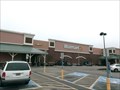 view gallery view galleryNE9.2 km |  Walmart SuperCenter #4487 - Aiken, SC Walmart SuperCenter #4487 - Aiken, SC
in WAL*MART Stores Walmart supercenter on the west side of Aiken, SC on US 1 posted by: gpsblake location: South Carolina date approved: 01/16/2015 last visited: never |
 view gallery view galleryNE9.7 km |  Dunkin Donuts - Aiken, SC Dunkin Donuts - Aiken, SC
in Dunkin Donuts' Dunkin Donuts on Richland Ave West (US 1) in Aiken, SC posted by: gpsblake location: South Carolina date approved: 01/12/2015 last visited: never |
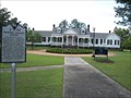 view gallery view galleryNE9.7 km |  Pickens House - Aiken, SC Pickens House - Aiken, SC
in U.S. National Register of Historic Places The Pickens House (also known as Pickens-Salley house) is located on the campus of the University of South Carolina-Aiken and was registered in the National Register of Historic places in 1983 posted by: gpsblake location: South Carolina date approved: 04/19/2015 last visited: never |
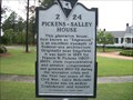 view gallery view galleryNE9.7 km | 2-24 Pickens Salley House - Aiken, SC in South Carolina Historical Markers Historical marker for Salley-Pickens house located on the campus of USC-Aiken. A nice large white building. It was originally in Edgefield County and moved to this location in 1989. posted by: gpsblake location: South Carolina date approved: 04/19/2015 last visited: never |
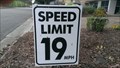 view gallery view gallery SW9.8 km SW9.8 km
|  19mph - Riverfront Dr, Goodale Landing community, Augusta GA 19mph - Riverfront Dr, Goodale Landing community, Augusta GA
in Unusual Speed Limits 19 mile per hour sign in Augusta GA posted by: gpsblake location: Georgia date approved: 10/20/2014 last visited: never |
 view gallery view gallery W10 km W10 km
| 2-2 Western Terminus South Carolina Railroad in South Carolina Historical Markers A marker just over the state line from Augusta. posted by: Markerman62 location: South Carolina date approved: 03/10/2015 last visited: 03/28/2015 |
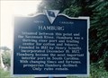 view gallery view galleryW10 km | 2-3 Hamburg in South Carolina Historical Markers Another marker just over the Savannah River from Augusta. posted by: Markerman62 location: South Carolina date approved: 04/07/2015 last visited: 04/08/2015 |
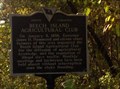 view gallery view galleryS10.3 km | Beech Island Agricultural Club in South Carolina Historical Markers A club that still meets, according to the marker. posted by: ChapterhouseInc location: South Carolina date approved: 02/28/2006 last visited: 06/13/2011 |
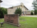
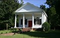 view gallery view galleryS10.3 km |  All Saints Episcopal Church - SC All Saints Episcopal Church - SC
in Country Churches Historic Church in Beach Island, SC posted by: gmgaston location: South Carolina date approved: 01/12/2011 last visited: 03/27/2011 |
 view gallery view gallerySW10.3 km |  Signal Corps Aviation School 1911-1913-GHM 121-44-Richmond Co Signal Corps Aviation School 1911-1913-GHM 121-44-Richmond Co
in Georgia Historical Markers Sand Bar Ferry at Oak Street, Augusta posted by: Sprinterman location: Georgia date approved: 09/27/2009 last visited: 07/25/2012 |
 view gallery view galleryS10.3 km | Historic Church in South Carolina Historical Markers Account of how the church was founded and the people involved. posted by: ChapterhouseInc location: South Carolina date approved: 02/28/2006 last visited: 05/01/2014 |
 view gallery view galleryS10.3 km | Beech Island Presbyterian Church (aka All Saints Episcopal Church) - Beech Island, SC in This Old Church In 1827, the Beech Island Presbyterian Church was organized, and the church, now known as All Saints Episcopal Church, was built in 1831. Note that the first linked historical site lists a different date as the historical plaque. posted by: ChapterhouseInc location: South Carolina date approved: 08/16/2006 last visited: 06/13/2011 |
 view gallery view gallery E10.3 km E10.3 km
|  The Reserve Club - Aiken, SC The Reserve Club - Aiken, SC
in Public and Private Golf Courses The Reserve Club at Woodside Plantation is located in Aiken, SC. posted by: papermanone & catlover location: South Carolina date approved: 05/04/2007 last visited: never |
 view gallery view galleryS10.3 km | Downer Institute & School / Downer School, 1924–1986 in South Carolina Historical Markers Downer Institute, Founded in 1843, was originally located 1.5 mi. NE of this site and operated until 1865. posted by: cdwilliams05 location: South Carolina date approved: 03/27/2011 last visited: 05/21/2014 |
 view gallery view gallerySW10.5 km | Home of Governor Telfair-GHM 121-13-Richmond Co in Georgia Historical Markers Broad Street at East Boundry, Augusta posted by: Sprinterman location: Georgia date approved: 09/27/2009 last visited: 07/25/2012 |
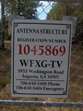 view gallery view galleryS10.5 km |  DE2291 - BEECH ISLAND TV STA WATU MAST DE2291 - BEECH ISLAND TV STA WATU MAST
in U.S. Benchmarks TV mast along the road in SC. posted by: ChapterhouseInc location: South Carolina date approved: 10/19/2008 last visited: 10/04/2005 |
 view gallery view gallerySW10.5 km |  Fire Station No. 1, Augusta Fire Department Fire Station No. 1, Augusta Fire Department
in Firehouses The first station of Augusta, Georgia’s numbered fire stations. posted by: DougK location: Georgia date approved: 05/26/2014 last visited: never |
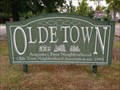 view gallery view gallerySW10.5 km |  Old Towne - Augusta, Georgia Old Towne - Augusta, Georgia
in Welcome Signs Olde Town claims to be "Augusta's First Neighborhood”. posted by: DougK location: Georgia date approved: 05/19/2014 last visited: never |
 view gallery view gallerySW10.5 km |  Fire Station Clock - Augusta, Georgia Fire Station Clock - Augusta, Georgia
in Town Clocks This clock is situated on a two-story high tower adjacent to the fire station. posted by: DougK location: Georgia date approved: 05/23/2014 last visited: never |
|