 view gallery view gallery NW4.3 km NW4.3 km
|   Corps of Engineers U.S. Army Survey Mark - Logan Martin Dam, St. Clair County, AL Corps of Engineers U.S. Army Survey Mark - Logan Martin Dam, St. Clair County, AL
in U.S. Benchmarks This survey disk, placed by the U.S. Army Corps of Engineers, is set flush in the south concrete curb on the west end of Logan Martin Dam on Logan Martin Dam Road on Logan Martin Lake in St. Clair County, Alabama. posted by:  Scooter Bill Scooter Bill location: Alabama date approved: 06/30/2007 last visited: 10/05/2013 |
 view gallery view gallery S6.6 km S6.6 km
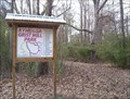
|  Kymulga Grist Mill Park Nature Trail - Childersburg, Alabama Kymulga Grist Mill Park Nature Trail - Childersburg, Alabama
in Self Guided Walks and Trails This scenic nature trail is located across the creek from an historic grist mill and is accessible by crossing an historic covered bridge. posted by: Scooter Bill location: Alabama date approved: 02/27/2009 last visited: never |
 view gallery view galleryS6.6 km |  Kymulga Mill and Covered Bridge - Childersburg, Alabama Kymulga Mill and Covered Bridge - Childersburg, Alabama
in U.S. National Register of Historic Places This 140 year-old historic grist mill and covered bridge is the centerpiece of a nature park and recreation. posted by: Scooter Bill location: Alabama date approved: 03/01/2009 last visited: never |
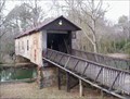 view gallery view galleryS6.6 km |  Kymulga Covered Bridge - Childersburg, Alabama Kymulga Covered Bridge - Childersburg, Alabama
in Covered Bridges This restored picturesque bridge was built just before the Civil War and is located near a working historic gristmill. posted by: Scooter Bill location: Alabama date approved: 02/21/2009 last visited: never |
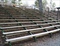 view gallery view galleryS6.6 km |  Kymulga Mill Park Amphitheater Seating - Childersburg, Alabama Kymulga Mill Park Amphitheater Seating - Childersburg, Alabama
in Eagle Scout Project Sites This Eagle Scout service project provided outdoor seating for entertainment and lectures at Kymulga Historic Park in Childersburg, AL posted by: Scooter Bill location: Alabama date approved: 02/27/2009 last visited: never |
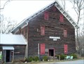 view gallery view galleryS6.6 km |  Kymulga Grist Mill - Childersburg, Alabama Kymulga Grist Mill - Childersburg, Alabama
in Water Mills Built over 140 years ago, this operating grist mill is undergoing restoration efforts to preserve the structure for many more generations to enjoy. posted by: Scooter Bill location: Alabama date approved: 02/24/2009 last visited: never |
 view gallery view gallery W9 km W9 km
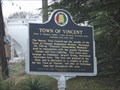
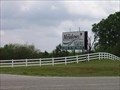
|  Town of Vincent Town of Vincent
in Alabama Historical Markers This Alabama Historical Marker is on Hwy 231 just east of the railroad underpass in Vincent, Alabama. posted by: PeterNoG location: Alabama date approved: 02/14/2012 last visited: 08/31/2013 |
 view gallery view galleryW9.7 km |  Vincent Fire Dept. Vincent Fire Dept.
in Firehouses This Firehouse is on Highway 25 (US Hwy 231) about 500 feet south of Raley Street in Vincent, Alabama. posted by: PeterNoG location: Alabama date approved: 03/17/2012 last visited: 08/31/2013 |
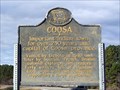 view gallery view galleryS10 km | Coosa - Childersburg, AL in Alabama Historical Markers Coosa, there are various spellings on markers within a few miles, was an important Indian town for over 250 years. posted by: hummerstation location: Alabama date approved: 01/11/2013 last visited: never |
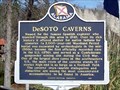 view gallery view galleryS10.3 km | DeSoto Caverns - Childersburg, AL in Alabama Historical Markers DeSoto Caverns was named for the famous Spanish explorer who traveled through the area in 1540. posted by: hummerstation location: Alabama date approved: 01/11/2013 last visited: never |
 view gallery view galleryS10.3 km |  DeSoto Caverns - Childersburg, AL DeSoto Caverns - Childersburg, AL
in Wikipedia Entries DeSoto Caverns was named for the famous Spanish explorer who traveled through the area in 1540. posted by: hummerstation location: Alabama date approved: 01/18/2013 last visited: never |
 view gallery view gallery SW10.8 km SW10.8 km
|  The Meadows - Harpersville, Alabama The Meadows - Harpersville, Alabama
in Public and Private Golf Courses This semi links-style course was built on flat terrain, so it is quite pleasant to walk. The fairways are generous, and the greens are medium-sized. Water hazards (eight lakes) come into play on twelve holes. The signature hole is #5, a 560-yard, par 5, requiring shots over a ditch, a creek and a lake to reach its small green. posted by: clevortrevor location: Alabama date approved: 04/08/2006 last visited: never |
 view gallery view gallerySW12.6 km | Historic Harpersville - Harpersville, AL in Alabama Historical Markers Harpersville is one of Shelby County’s oldest communities. Its existence precedes that of Shelby County and the State of Alabama. posted by: hummerstation location: Alabama date approved: 12/06/2012 last visited: never |
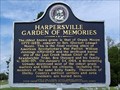 view gallery view gallerySW13.2 km | Harpersville Garden of Memories - Harpersville, AL in Alabama Historical Markers Harpersville Garden of Memories, where the oldest known grave is that of Oprah Moore (1772-1823), consort to Rev. (Doctor) Lemuel Moore. posted by: hummerstation location: Alabama date approved: 09/18/2012 last visited: 10/05/2013 |
 view gallery view gallerySW13.2 km | Harpersville Fire Department in Firehouses Local fire department for Harpersville, Alabama. posted by: Blazer3T location: Alabama date approved: 03/26/2022 last visited: never |
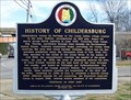 view gallery view galleryS13.2 km | History of Childersburg - Childersburg, AL in Alabama Historical Markers Childersburg traces its heritage to the Coosa Indian village located in the area visited by DeSoto in the 1540s. posted by: hummerstation location: Alabama date approved: 01/11/2013 last visited: 08/31/2013 |
 view gallery view galleryS13.5 km |  Indian Town Cosa Indian Town Cosa
in Signs of History This Sign of History is at the corner of US Hwy 231 and County Road 8 in Childersburg, Alabama. posted by: PeterNoG location: Alabama date approved: 03/01/2012 last visited: 01/09/2012 |
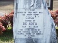 view gallery view galleryS13.5 km | Cosa - Childersburg, AL in Alabama Historical Markers Cosa, Coosa, and Coca are all names for the same Indian villagee visited by DeSoto in 1540. The three names can be found on three historical markers within about three miles of this marker. posted by: hummerstation location: Alabama date approved: 01/11/2013 last visited: 08/26/2013 |
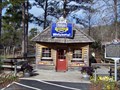
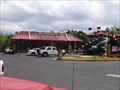 view gallery view galleryS14.6 km |  Childersburg, Alabama - AL Hwy 280. Childersburg, Alabama - AL Hwy 280.
in McDonald's Restaurants Located just off of AL Hwy 280 West, Childersburg, Alabama. posted by: clevortrevor location: Alabama date approved: 04/08/2006 last visited: 02/23/2008 |
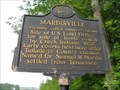 view gallery view gallery E14.8 km E14.8 km
| Mardisville in Alabama Historical Markers A marker with a brief story about a office that used to be here. posted by: Lazer location: Alabama date approved: 05/26/2008 last visited: 01/07/2023 |
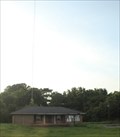
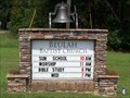 view gallery view galleryW16.1 km |  Beulah Baptist Church Bell - Sterrett, AL Beulah Baptist Church Bell - Sterrett, AL
in Bells Cast steel church at Beulah Baptist Church posted by: hummerstation location: Alabama date approved: 09/25/2012 last visited: never |
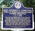 view gallery view galleryW16.1 km | Old Sterrett Cemetery - Sterrett, AL in Alabama Historical Markers Old Sterrett Cemetery originally known as “Cedars of Beulah Land Burial Ground” posted by: hummerstation location: Alabama date approved: 09/14/2012 last visited: never |
 view gallery view gallery NE16.6 km NE16.6 km
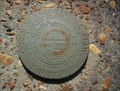
| Corps of Engineers U.S. Army Survey Mark - Stemley Bridge, St. Clair County, AL in U.S. Benchmarks This survey disk, placed by the U.S. Army Corps of Engineers, is set flush in the south concrete guard rail support on the west end of Stemley Bridge on Stemley Bridge Road over Logan Martin Lake in St. Clair County, Alabama. posted by: Scooter Bill location: Alabama date approved: 06/30/2007 last visited: never |
 view gallery view galleryE18.3 km |  Legacy WHTB/WNUZ/WPPT-AM 1230 -- Talladega Co. AL USA Legacy WHTB/WNUZ/WPPT-AM 1230 -- Talladega Co. AL USA
in Radio and Television Transmitter Towers WHTB/WNUZ/WPPT-AM 1230 formerly served the greater Talladega Co. AL area from its transmitter along AL state highway 21 posted by: Benchmark Blasterz location: Alabama date approved: 09/05/2017 last visited: 07/26/2017 |
 view gallery view gallery N18.5 km N18.5 km
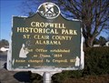
| Cropwell Historical Park - Saint Clair County, AL in Alabama Historical Markers This marker is located at a small historical park that celebrates the rich histoy of the town of Cropwell, AL. posted by: Scooter Bill location: Alabama date approved: 07/04/2008 last visited: never |
|