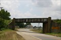
 view gallery view gallery NW13.4 km NW13.4 km
|   Cotton Belt RR Bridge -- Garland AR Cotton Belt RR Bridge -- Garland AR
in Railroad Bridges Blasterz are from Garland TX, and cannot resist waymarking this cool girder-style RR bridge in Garland AR posted by:  Benchmark Blasterz Benchmark Blasterz location: Arkansas date approved: 10/13/2014 last visited: 10/14/2014 |
 view gallery view gallery W26.2 km W26.2 km
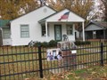
|  LEGEND OF BOGGY CREEK LEGEND OF BOGGY CREEK
in Photo Cutouts Statue and photo op of the Creature from Boggy Creek, the southern version of bigfoot. Also called the Fouke Monster. Museum (sort of) nearby.Photo is my "little monster" posted by: bro.bobby70 location: Arkansas date approved: 08/20/2012 last visited: 08/27/2012 |
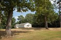 view gallery view gallery S31.2 km S31.2 km
|  Chalybeate Springs Missionary Baptist Church - Plain Dealing, Louisiana. Chalybeate Springs Missionary Baptist Church - Plain Dealing, Louisiana.
in Country Churches This church is located about 8-miles northeast of Plain Dealing Louisiana, about a .5 mile south of the Arkansas state line. posted by:  misfitt misfitt location: Louisiana date approved: 01/04/2009 last visited: never |
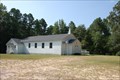
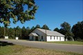 view gallery view galleryS31.7 km | Shiloh Missionary Baptist Church - Springhill, Louisiana. in Country Churches It is located about four miles east of Springhill. It is located in a sparsely settled area of the rolling wooded hill country of northwest Louisiana. posted by: misfitt location: Louisiana date approved: 12/09/2008 last visited: never |
 view gallery view galleryS33.6 km | Oak Hill Baptist Church - Plain Dealing, Louisiana. in Country Churches This church is located about 6.5-miles north of Plain Dealing on the Hamter Road about .5-mile east of highway LA-3.
posted by: misfitt location: Louisiana date approved: 01/04/2009 last visited: never |
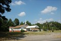
 view gallery view gallery SE34.6 km SE34.6 km
|  Springhill, Louisiana 71075 Springhill, Louisiana 71075
in U.S. Post Offices This is the Post Office for the town of Spring Hill Louisiana. It is located in Webster Parish in the wooded rolling hill country of northwest Louisiana. The population was 5,439 at the 2000 census. posted by: misfitt location: Louisiana date approved: 12/19/2008 last visited: never |
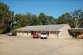
 view gallery view galleryNW37.7 km |  Gossett family -- Rondo Cemetery, Rondo, AR Gossett family -- Rondo Cemetery, Rondo, AR
in Homemade Tombstones Multiple grave markers for Gossett family members. Located in the well-kept and attractive grounds of Rondo Cemetery in Rondo, Arkansas. posted by: techiegrl64 location: Arkansas date approved: 12/08/2008 last visited: 04/26/2011 |
 view gallery view galleryNW37.7 km |  Confederate Section--Old Rondo Cemetery -- Rondo, AR Confederate Section--Old Rondo Cemetery -- Rondo, AR
in U.S. National Register of Historic Places Many Confederate graves are located at this cemetery, many of them unknown. posted by: techiegrl64 location: Arkansas date approved: 12/03/2008 last visited: 04/26/2011 |
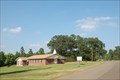
 view gallery view gallerySE38.9 km | Antioch Church of Christ - Shongaloo, Louisiana. in Country Churches It is located almost on the Louisiana Arkansas state line in a sparsely settled area of the rolling wooded hill country of northwest Louisiana. It is not really at Shongaloo but it is about the nearest town seven miles to the southeast. posted by: misfitt location: Louisiana date approved: 12/09/2008 last visited: never |
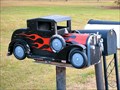 view gallery view galleryNW39.1 km |  Souped up vintage truck -- Rondo, AR Souped up vintage truck -- Rondo, AR
in Themed Homemade Mailboxes This mailbox features a souped-up vintage truck. Located on the east side of Hwy 237 just north of Rondo, Arkansas. posted by: techiegrl64 location: Arkansas date approved: 12/04/2008 last visited: 12/13/2008 |
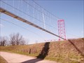 view gallery view galleryNW39.3 km |  Pipeline Bridge at Fulton, AR Pipeline Bridge at Fulton, AR
in Suspension Bridges Enjoy this unique Pipeline Suspension Bridge. posted by: 8Nuts MotherGoose location: Arkansas date approved: 04/27/2007 last visited: 05/08/2009 |
 view gallery view galleryS39.3 km | Bethel Church of God In Christ - Plain Dealing, Louisiana. in Country Churches This church is located about 2.5-miles northeast of Plain Dealing. posted by: misfitt location: Louisiana date approved: 01/04/2009 last visited: never |
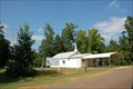
 view gallery view galleryNW39.4 km |  I-30 EB Welcome Center - Texarkana, AR I-30 EB Welcome Center - Texarkana, AR
in Highway Rest Areas Located on I-30 EB just east of Texarkana, AR. posted by: Lat34North location: Arkansas date approved: 11/15/2009 last visited: 05/25/2017 |
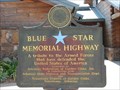 view gallery view galleryNW39.4 km |  I-30 EB Welcome Center, Texarkana, AR I-30 EB Welcome Center, Texarkana, AR
in Blue Star Memorial Highway Markers Located in front of the Texarkana, AR Welcome Center, just off the eastbound side if Interstate 30. posted by: QuesterMark location: Arkansas date approved: 08/30/2008 last visited: 03/07/2015 |
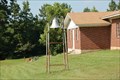
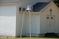 view gallery view galleryS39.6 km |  Bell at Israelite Baptist Church - Plain Dealing, Louisiana Bell at Israelite Baptist Church - Plain Dealing, Louisiana
in Bells This bell is located at the Israelite Baptist Church about2.5-miles north of Plain Dealing, Louisiana on highway LA-3. This is a classic example of an old southern country church.
posted by: misfitt location: Louisiana date approved: 12/25/2007 last visited: never |
 view gallery view galleryS39.6 km | Israelite Baptist Church - Plain Dealing, Louisiana. in Country Churches This church is located about 3.5-miles north of Plain Dealing, Louisiana. posted by: misfitt location: Louisiana date approved: 01/04/2009 last visited: never |
 view gallery view galleryS39.6 km | Rock Spring Baptist Church # 2 - Plain Dealing, Louisiana. in Country Churches This church is located about 2.5-miles northeast of Plain Dealing. posted by: misfitt location: Louisiana date approved: 01/04/2009 last visited: never |
 view gallery view galleryS39.6 km | Bell at Rock Springs Baptist Church No 2 - Plain Dealing, Louisiana in Bells Bell at Rock Springs Baptist Church No 2 - Plain Dealing, Louisiana posted by: misfitt location: Louisiana date approved: 12/25/2007 last visited: never |
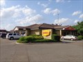 view gallery view galleryNW40.1 km |  Denny's - Flying J on AR 108 - Texarkana, AR Denny's - Flying J on AR 108 - Texarkana, AR
in Denny's Restaurants Denny's located in the Flying J Travel Plaza at 8300 State Highway 108, Texarkana, AR 71854. Phone is 870-772-3540. posted by: QuarrellaDeVil location: Arkansas date approved: 04/27/2014 last visited: 08/09/2015 |
 view gallery view gallery N40.4 km N40.4 km
|  Boyhood home of Bill Clinton -- Hope, AR Boyhood home of Bill Clinton -- Hope, AR
in Presidential Birthplaces Boyhood home of William J. Clinton, located in Hope, Arkansas. posted by: techiegrl64 location: Arkansas date approved: 12/03/2008 last visited: 02/11/2022 |
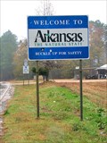 view gallery view gallery SW40.6 km SW40.6 km
|  Welcome to Arkansas -- the Natural State Welcome to Arkansas -- the Natural State
in Welcome Signs Sign at border crossing from Louisiana into Arkansas, just north of Ida, Louisiana. posted by: techiegrl64 location: Arkansas date approved: 12/04/2008 last visited: 08/31/2013 |
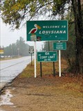 view gallery view gallerySW40.6 km |  Arkansas - Louisiana border Arkansas - Louisiana border
in Border Crossings Sign at border crossing from Arkansas into Louisiana, just north of Ida, Louisiana.
posted by: techiegrl64 location: Louisiana date approved: 12/07/2008 last visited: 05/24/2021 |
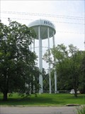 view gallery view galleryN40.9 km |  Water Tower Hope, AR Water Tower Hope, AR
in Water Towers One big tower. posted by: BackPak location: Arkansas date approved: 07/13/2007 last visited: 03/07/2015 |
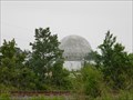 view gallery view galleryNW40.9 km |  Radar Dome, Texarkana Airport grounds, Texarkana, AR Radar Dome, Texarkana Airport grounds, Texarkana, AR
in Abandoned Air Force Radar Sites Abandoned radar dome located at the Texarkana Airport. This site was active in the 1950s into the 1960s. Coordinates logged from the shoulder of Highway 67 as this was as close as I could get as it is now part of airport property. posted by: TMSCurator location: Arkansas date approved: 05/09/2011 last visited: 07/05/2019 |
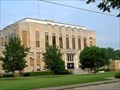 view gallery view galleryN41 km | Hempstead County Courthouse - Hope, AR in U.S. National Register of Historic Places Erected by the Public Works Administration in 1940. Architect was B.W. Edwards. posted by: WalksfarTX location: Arkansas date approved: 11/14/2018 last visited: never |
|