 view gallery view gallery NE5.6 km NE5.6 km
|   Clay County Courthouse - Ashland, AL Clay County Courthouse - Ashland, AL
in U.S. National Register of Historic Places Clay County Courthouse posted by:  wmize wmize location: Alabama date approved: 05/16/2011 last visited: 07/12/2012 |
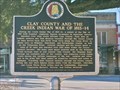
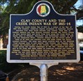 view gallery view galleryNE5.6 km |  Clay County and the Creek Indian War of 1813-14 - Ashland, AL Clay County and the Creek Indian War of 1813-14 - Ashland, AL
in Alabama Historical Markers Located on the grounds of the Clay County Courthouse notes the trails and areas of the future Clay County used in the Creek Indian wars of 1813-1814. posted by: hoteltwo location: Alabama date approved: 06/21/2016 last visited: never |
 view gallery view galleryNE5.6 km | Clay County and the Creek Indian Confederacy - Ashland, AL in Alabama Historical Markers Located on the lawn of the Clay County Courthouse explains the importance of Clay County area on the Creek Indian confederacy, the trails and lands used by the Creeks and the treaties involved. posted by: hoteltwo location: Alabama date approved: 06/25/2016 last visited: 01/23/2023 |
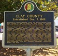 view gallery view galleryNE5.6 km | Clay County - Ashland, Alabama in Alabama Historical Markers Located on the grounds of the Clay County Courthouse near Court Square and 2nd Avenue. It describes how Clay County was formed and its historical place names within the county. posted by: hoteltwo location: Alabama date approved: 06/25/2016 last visited: never |
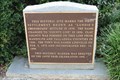
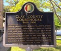 view gallery view galleryNE5.6 km | Clay County Courthouse - Ashland, AL in Alabama Historical Markers Marker located on the grounds of the Clay County courthouse at Court Square notes the history of the courthouse and famous county politicians. posted by: hoteltwo location: Alabama date approved: 06/25/2016 last visited: never |
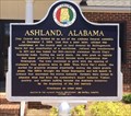 view gallery view galleryNE5.6 km | Ashland, Alabama in Alabama Historical Markers Marker located in front of the Ashland City Hall notes the early and current history of the city. posted by: hoteltwo location: Alabama date approved: 06/25/2016 last visited: never |
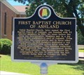 view gallery view galleryNE6.1 km | First Baptist Church of Ashland - Ashland, AL in Alabama Historical Markers Located on 1st Ave. just north of 5th St. notes the founding of the church and its subsequent buildings used by the congregation. posted by: hoteltwo location: Alabama date approved: 06/21/2016 last visited: never |
 view gallery view galleryNE13.7 km |  Incorporation of Lineville - 100 Years - Lineville, AL Incorporation of Lineville - 100 Years - Lineville, AL
in Commercial Commemorations This sign of history preserves the memory of Lundie's Crossroads, a precursor to modern-day Lineville AL, and celebrates Lineville's centennial of incorporation as a city posted by:  Benchmark Blasterz Benchmark Blasterz location: Alabama date approved: 09/06/2017 last visited: 07/26/2017 |
 view gallery view galleryNE13.7 km |  Site of Lundie's Crossroads -- Lineville AL Site of Lundie's Crossroads -- Lineville AL
in Signs of History This sign of history preserves the memory of Lundie's Crossroads, a precursor to modern-day Lineville AL posted by: Benchmark Blasterz location: Alabama date approved: 09/02/2017 last visited: 07/27/2017 |
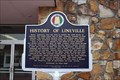
 view gallery view galleryNE13.7 km | History of Lineville -- Lineville AL in Alabama Historical Markers The state historic marker in front of Lineville City Hall in Lineville AL posted by: Benchmark Blasterz location: Alabama date approved: 09/07/2017 last visited: 07/28/2017 |
 view gallery view galleryNE13.7 km |  FIRST -- Mayor of Lineville, Lineville AL FIRST -- Mayor of Lineville, Lineville AL
in First of its Kind The first Mayor of Lineville, H. J. Willingham, was appointed in 1891. posted by: Benchmark Blasterz location: Alabama date approved: 09/01/2017 last visited: 07/27/2017 |
 view gallery view galleryNE13.7 km | FIRST -- White settlers in the area, Lineville AL in First of its Kind The first white settlers in what would become Lineville were brothers William and Thomas Lundie. posted by: Benchmark Blasterz location: Alabama date approved: 09/01/2017 last visited: 07/27/2017 |
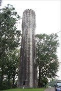 view gallery view galleryNE14 km |  Lineville Water Tower -- Lineville AL Lineville Water Tower -- Lineville AL
in Water Towers The historic Lineville Water Tower is on the Alabama Register of Landmarks and Heritage. posted by: Benchmark Blasterz location: Alabama date approved: 09/02/2017 last visited: 07/27/2017 |
 view gallery view gallery SW17.7 km SW17.7 km
| Battle of Enitachopko - Goodwater, AL in Alabama Historical Markers At the intersection of AL-9 and AL-63, in Clay County, it notes the nearby battle fought by Gen. Andrew Jackson & the Creek Indians at the Creek village of Anatichapko, Jan. 24, 1814, and 2 days immediately following the battle of Emuckfau. posted by: hoteltwo location: Alabama date approved: 06/21/2016 last visited: never |
 view gallery view gallery S23.3 km S23.3 km
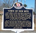
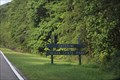
| Town of New Site - New Site, AL in Alabama Historical Markers The Town of New Site was incorporated on August 23, 1965, to establish a public water system. posted by: hummerstation location: Alabama date approved: 02/25/2016 last visited: 07/27/2017 |
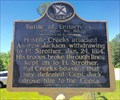
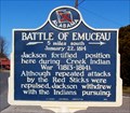 view gallery view galleryS23.3 km | Battle of Emucfau - New Site, AL in Alabama Historical Markers The Battle of Emucfau occurred January 22, 1814. posted by: hummerstation location: Alabama date approved: 02/25/2016 last visited: 07/27/2017 |
 view gallery view gallery N27.4 km N27.4 km
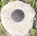
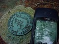
|  15-35 15-35
in U.S. Benchmarks Benchmark located inside Cheaha State Park near Cheaha Lake posted by: jbuffethed location: Alabama date approved: 03/22/2011 last visited: never |
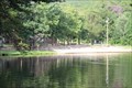 view gallery view galleryN27.4 km |  Bathhouse -- Mt Cheaha State Park, Delta AL Bathhouse -- Mt Cheaha State Park, Delta AL
in Civilian Conservation Corps The beautiful bathhouse and swimming lake at Mt Cheaha State Park, near Delta AL, is one of several park amenities built by the CCC still delighting visitors in 2017 posted by: Benchmark Blasterz location: Alabama date approved: 09/06/2017 last visited: 07/26/2017 |
 view gallery view galleryN27.8 km |  Mt. Cheaha State Park - Delta, AL Mt. Cheaha State Park - Delta, AL
in State/Provincial Parks Mt. Cheaha State Park, a jewel in the Talladega Mountains near Delta AL posted by: Benchmark Blasterz location: Alabama date approved: 09/04/2017 last visited: 12/21/2021 |
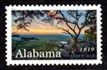 view gallery view galleryN28.3 km |  Pulpit Rock, Cheaha State Park, Alabama Pulpit Rock, Cheaha State Park, Alabama
in Philatelic Photographs A view from the top of Alabama graces this 2019 stamp commemorating the state’s 200th anniversary. posted by: hykesj location: Alabama date approved: 05/09/2019 last visited: never |
 view gallery view galleryN28.5 km |  DG3597 #T18SR8E DG3597 #T18SR8E
in Public Land Survey Marks A 1939 quad marker that is not listed very many places. posted by: supertech location: Alabama date approved: 06/13/2014 last visited: never |
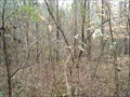 view gallery view gallerySW28.5 km |  N 33° W 86° Alabama, USA N 33° W 86° Alabama, USA
in Confluence Spots This confluence point is extremely difficult to reach. It is one that is in the middle of nowhere. posted by:  mtn-man mtn-man location: Alabama date approved: 08/11/2006 last visited: never |
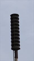 view gallery view galleryN28.8 km |  Cheaha Mountain Siren -- Mt Cheaha State Park, Delta AL Cheaha Mountain Siren -- Mt Cheaha State Park, Delta AL
in Outdoor Warning Sirens The outdoor warning siren atop Cheaha Mountian, and highest geographic point in AL posted by: Benchmark Blasterz location: Alabama date approved: 09/04/2017 last visited: 12/06/2021 |
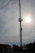 view gallery view galleryN28.8 km |  WCIQ-DTV Channel 7 -- Mt Cheaha State Park, Delta AL USA WCIQ-DTV Channel 7 -- Mt Cheaha State Park, Delta AL USA
in Radio and Television Transmitter Towers The TV transmitter tower for WCIQ-DTV, an affiliate of the Alabama Public Television state network, stands atop Mt Cheaha, the highest point in the state of AL posted by: Benchmark Blasterz location: Alabama date approved: 09/04/2017 last visited: 12/06/2021 |
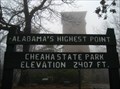 view gallery view galleryN28.8 km |  Alabama's Highest Point, Cheaha State Park, Elevation 2407 FT. Alabama's Highest Point, Cheaha State Park, Elevation 2407 FT.
in Elevation Signs Elevation sign atop Cheaha Mountain, Alabama's Highest Point posted by: jkselby location: Alabama date approved: 12/12/2009 last visited: 12/06/2021 |
|