 view gallery view gallery N10 km N10 km
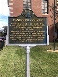
|   Randolph County Randolph County
in Alabama Historical Markers Located in front of the Randolph County Courthouse. posted by:  flyingmoose flyingmoose location: Alabama date approved: 12/18/2021 last visited: 01/11/2022 |
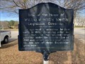 view gallery view galleryN10.1 km | Site of the Home of William Hugh Smith Legislator, Governor - Wedowee, AL in Alabama Historical Markers Located in the median of US 431 near Woodland Avenue, Wedowee posted by: Markerman62 location: Alabama date approved: 03/30/2022 last visited: never |
 view gallery view gallery E10.5 km E10.5 km
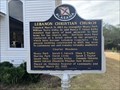
| Lebanon Christian Church - Roanoke, AL in Alabama Historical Markers Located on CR 79 at CR 667 and CR 670, Roanoke posted by: Markerman62 location: Alabama date approved: 03/30/2022 last visited: never |
 view gallery view galleryE10.5 km | Lebanon Christian Church Cemetery - Roanoke, AL in Alabama Historical Markers Located on CR 79 at CR 667 and CR 670, Roanoke posted by: Markerman62 location: Alabama date approved: 03/30/2022 last visited: never |
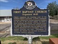 view gallery view gallery SE11.1 km SE11.1 km
| First Baptist Church Organized 1845 - Roanoke, AL in Alabama Historical Markers Located on Main Street and Church Street, Roanoke posted by: Markerman62 location: Alabama date approved: 03/30/2022 last visited: never |
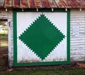
 view gallery view gallery SW15.1 km SW15.1 km
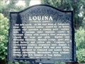
| Louina in Alabama Historical Markers On AL 22 just east of the Tallapoosa River bridge. posted by: Markerman62 location: Alabama date approved: 03/22/2015 last visited: 03/11/2015 |
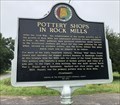 view gallery view gallerySE16.6 km | Pottery Shops in Rock Mills - Rock Mills, AL in Alabama Historical Markers Located on CR 91 at CR 2206, this marker notes the many potteries established in the area and the wares produced. posted by:  hoteltwo hoteltwo location: Alabama date approved: 07/20/2018 last visited: never |
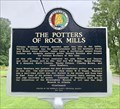 view gallery view gallerySE16.6 km | The Potters of Rock Mills - Rock Mills, AL in Alabama Historical Markers Located on CR 91 at CR 2206, this two-sided marker notes the many families and potteries established in the area and the wares produced. posted by: hoteltwo location: Alabama date approved: 07/20/2018 last visited: never |
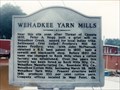 view gallery view gallerySE17.1 km | Wehadkee Yarn Mills in Alabama Historical Markers On AL 22 at Wehadkee Creek in Rock Mills. posted by: Markerman62 location: Alabama date approved: 03/22/2015 last visited: 06/03/2018 |
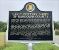 view gallery view gallerySE18.5 km | Early Pottery Shops of Randolph County - Bacon Level, AL in Alabama Historical Markers Located on CR 16 at CR 75, this marker notes the pottery industry settlers of the local area. It describes where the potter families came from to settle here and where they ventured. posted by: hoteltwo location: Alabama date approved: 07/20/2018 last visited: never |
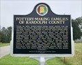 view gallery view gallerySE18.5 km | Pottery-Making Families of Randolph County - Bacon Level, AL in Alabama Historical Markers Located on CR 16 at CR 75, this marker notes the pottery industry of the local area. They used the local porcelain white clay, and some local red clay with an outer glaze of hickory ashes giving a tan or brown glaze. posted by: hoteltwo location: Alabama date approved: 07/20/2018 last visited: never |
 view gallery view gallerySE24.6 km | First Consolidated High School in the State of Alabama - Five Points, AL in Alabama Historical Markers Located on US 431 at County Road 222, Five Points posted by: Markerman62 location: Alabama date approved: 03/30/2022 last visited: never |
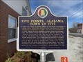 view gallery view gallerySE24.8 km | Five Points, Alabama: Town of Five - Five Points, AL in Alabama Historical Markers Located on US 431 in front of Five Points Town Hall posted by: Markerman62 location: Alabama date approved: 03/30/2022 last visited: never |
 view gallery view gallerySW25.6 km | Daviston, Alabama - Daviston, AL in Alabama Historical Markers Daviston, Alabama, incorporated February 16, 1887, is believed to be the first incorporated rural town in Tallapoosa County. posted by: hummerstation location: Alabama date approved: 02/25/2016 last visited: never |
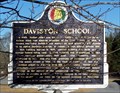 view gallery view gallerySW25.6 km | Daviston School - Daviston, AL in Alabama Historical Markers At the time of its closing in 1988 Daviston School was the smallest school in Alabama with 120 K-12 students. posted by: hummerstation location: Alabama date approved: 02/25/2016 last visited: never |
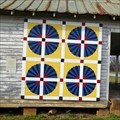 view gallery view gallery NE27.5 km NE27.5 km
|  Fan Quilt Square - Ephesus, GA Fan Quilt Square - Ephesus, GA
in Painted Barn Quilts The Fan Quilt Square is located on what is now a storage building on GA Hwy 100. posted by: hummerstation location: Georgia date approved: 03/03/2020 last visited: never |
 view gallery view galleryNE27.5 km | Sawtooth Quilt Square - Ephesus, GA in Painted Barn Quilts This Sawtooth Quilt Square is located on what is now a storage building on GA Hwy 100. posted by: hummerstation location: Georgia date approved: 03/03/2020 last visited: never |
 view gallery view galleryNE27.7 km | Overall Sam and Sunbonnet Sue Quilt Square - Ephesus, GA in Painted Barn Quilts The Overall Sam and Sunbonnet Sue Quilt Square is located on the Ephesus Elementary School building on GA Hwy 100. posted by: hummerstation location: Georgia date approved: 03/03/2020 last visited: never |
 view gallery view galleryNE27.7 km |  Ephesus, Georgia Ephesus, Georgia
in Wikipedia Entries Ephesus is the youngest Heard County Municipality, the City of Ephesus was incorporated in 1964. posted by: hummerstation location: Georgia date approved: 03/02/2020 last visited: never |
 view gallery view galleryNE27.7 km |  Ephesus, Georgia Ephesus, Georgia
in City and Town Halls The Ephesus City Hall is located on the east side of GA Highway 100. posted by: hummerstation location: Georgia date approved: 03/11/2020 last visited: never |
 view gallery view galleryNE27.7 km |  Ephesus, Georgia Ephesus, Georgia
in Names From the Bible Ephesus is a city in Heard County, Georgia, United States. The Ephesus of the Bible was a city in the Roman province of Asia. posted by: hummerstation location: Georgia date approved: 03/17/2020 last visited: never |
 E28.2 km |  PRAYING MANTIS- on a tree finger PRAYING MANTIS- on a tree finger
in Ginormous Everyday Objects This oversized display is located in Ephesus Georgia posted by: Icache4Life location: Georgia date approved: 11/19/2005 last visited: never |
 view gallery view gallery W29.5 km W29.5 km
|  Site of Lundie's Crossroads -- Lineville AL Site of Lundie's Crossroads -- Lineville AL
in Signs of History This sign of history preserves the memory of Lundie's Crossroads, a precursor to modern-day Lineville AL posted by: Benchmark Blasterz location: Alabama date approved: 09/02/2017 last visited: 07/27/2017 |
 view gallery view galleryW29.5 km |  Incorporation of Lineville - 100 Years - Lineville, AL Incorporation of Lineville - 100 Years - Lineville, AL
in Commercial Commemorations This sign of history preserves the memory of Lundie's Crossroads, a precursor to modern-day Lineville AL, and celebrates Lineville's centennial of incorporation as a city posted by: Benchmark Blasterz location: Alabama date approved: 09/06/2017 last visited: 07/26/2017 |
 view gallery view galleryW29.5 km |  FIRST -- White settlers in the area, Lineville AL FIRST -- White settlers in the area, Lineville AL
in First of its Kind The first white settlers in what would become Lineville were brothers William and Thomas Lundie. posted by: Benchmark Blasterz location: Alabama date approved: 09/01/2017 last visited: 07/27/2017 |
|