 view gallery view gallery E3.7 km E3.7 km
|   Fayetteville - Fayetteville, AL Fayetteville - Fayetteville, AL
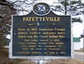
in Alabama Historical Markers Tennessee veterans of the Creek Indian War named this community for their old home in Tennessee. posted by:  hummerstation hummerstation location: Alabama date approved: 01/11/2013 last visited: 08/29/2013 |
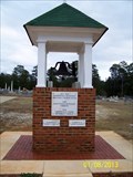 view gallery view galleryE3.9 km |  Fayetteville United Methodist Church Bell - Fayetteville, AL Fayetteville United Methodist Church Bell - Fayetteville, AL
in Bells Bell from the old Fayetteville United Methodist Church building. posted by: hummerstation location: Alabama date approved: 01/12/2013 last visited: 08/29/2013 |
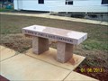 view gallery view galleryE3.9 km |  James & Mavis Edmondson - Fayetteville, AL James & Mavis Edmondson - Fayetteville, AL
in Dedicated Benches A dedicated bench located at Fayetteville United Methodist Church. posted by: hummerstation location: Alabama date approved: 01/28/2013 last visited: 08/29/2013 |
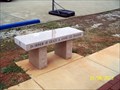 view gallery view galleryE3.9 km | Grady & Annie Lee Graham - Fayetteville, AL in Dedicated Benches A dedicated bench located at Fayetteville United Methodist Church. posted by: hummerstation location: Alabama date approved: 01/28/2013 last visited: 08/29/2013 |
 view gallery view gallery NW9.8 km NW9.8 km
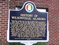
| History of Wilsonville, Alabama - Wilsonville, AL in Alabama Historical Markers Wilsonville, named for Adam Wilson, was incorporated in 1897. posted by: hummerstation location: Alabama date approved: 12/06/2012 last visited: never |
 view gallery view gallery N9.8 km N9.8 km
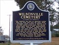
| Wilsonville Cemetery - Wilsonville, AL in Alabama Historical Markers Wilsonville Cemetery has been an important burying place since the early 1800s. The earliest marked grave dates to 1854. posted by: hummerstation location: Alabama date approved: 12/06/2012 last visited: 02/25/2014 |
 view gallery view galleryN9.8 km |  Wilsonville Cemetery - Wilsonville, AL Wilsonville Cemetery - Wilsonville, AL
in Worldwide Cemeteries The oldest marked grave in Wilsonville Cemetery dates to 1854. posted by: hummerstation location: Alabama date approved: 12/10/2012 last visited: never |
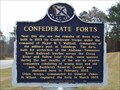 view gallery view galleryN11.1 km | Confederate Forts - Wilsonville, AL in Alabama Historical Markers Three forts were built near Wilsonville in 1863 by Confederate troops to protect the Alabama-Tennessee River Railroad trestles across the Coosa River and Yellow Leaf Creek. posted by: hummerstation location: Alabama date approved: 12/06/2012 last visited: never |
 view gallery view gallery NE13.7 km NE13.7 km
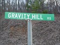
|  Gravity Hill Road - Sylacauga, Alabama Gravity Hill Road - Sylacauga, Alabama
in Vortexes, Mystery Spots, and Gravity Hills Located west of Alabama's US 280 is a spot where generations of teenagers have witnessed their cars roll "uphill" when left in neutral.
posted by: Scooter Bill location: Alabama date approved: 02/20/2009 last visited: 02/03/2011 |
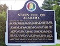 view gallery view galleryE14.3 km | Stars Fell on Alabama/Hodges Meteorite - Oak Grove, AL in Alabama Historical Markers On November 30, 1954 the first modern instance of a meteorite striking a human being occured near the marker location. posted by: hummerstation location: Alabama date approved: 07/22/2012 last visited: 02/25/2014 |
 view gallery view galleryE15 km |  Faye's Bar-B-Que - Sylacauga, AL Faye's Bar-B-Que - Sylacauga, AL
in Classic BBQ and Sandwich Joints The scariest looking places are usually the best joints to eat at. posted by: nomadwillie location: Alabama date approved: 02/18/2013 last visited: never |
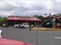 view gallery view galleryNE15 km |  Childersburg, Alabama - AL Hwy 280. Childersburg, Alabama - AL Hwy 280.
in McDonald's Restaurants Located just off of AL Hwy 280 West, Childersburg, Alabama. posted by: clevortrevor location: Alabama date approved: 04/08/2006 last visited: 02/23/2008 |
 view gallery view galleryE15.1 km |  Imerys Gantt’s Quarry - Sylacauga, AL Imerys Gantt’s Quarry - Sylacauga, AL
in Active Quarries From the Imerys Gantt’s Quarry Observation Point one can see the historical pit and learn about the current activities of the quarry. posted by: xptwo location: Alabama date approved: 09/08/2012 last visited: 10/09/2021 |
 view gallery view gallery W15.4 km W15.4 km
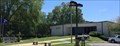
|  Columbiana, Alabama Columbiana, Alabama
in City and Town Halls The City Hall for Columbiana houses the City Clerk, the Municipal Court, the Mayor's office and City Council and other offices. posted by:  hoteltwo hoteltwo location: Alabama date approved: 08/21/2014 last visited: never |
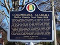 view gallery view galleryW15.4 km | Columbiana, Alabama - Columbiana, AL in Alabama Historical Markers Columbiana, originally called Columbia, was selected as the county seat of Shelby County in 1826. posted by: hummerstation location: Alabama date approved: 11/29/2012 last visited: 08/14/2014 |
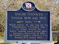 view gallery view galleryW15.4 km | Shelby Furnaces - Columbiana, AL in Alabama Historical Markers The Shelby Furnaces were a major source of pig iron for the Confederate States of America. posted by: hummerstation location: Alabama date approved: 11/29/2012 last visited: 08/14/2014 |
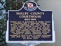 view gallery view galleryW15.4 km | Shelby County Courthouse 1854-1908 - Columbiana, AL in Alabama Historical Markers The "Old Shebly County Courthouse", built in 1854, was the second county courthouse. It served the county until 1908. posted by: hummerstation location: Alabama date approved: 11/29/2012 last visited: 08/14/2014 |
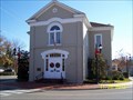 view gallery view galleryW15.4 km |  Columbiana City Hall - Columbiana, AL Columbiana City Hall - Columbiana, AL
in U.S. National Register of Historic Places The Columbiana City Hall, also known as the Shelby County Courthouse, is housed in the courthouse built in 1854. posted by: hummerstation location: Alabama date approved: 12/05/2012 last visited: 08/14/2014 |
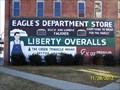 view gallery view galleryW15.4 km |  Eagles Store Mural - Columbiana, AL Eagles Store Mural - Columbiana, AL
in Murals Liberty Overall mural on the side of a former department store. posted by: hummerstation location: Alabama date approved: 01/12/2013 last visited: never |
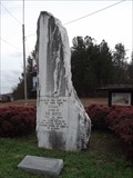
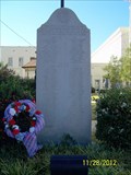 view gallery view galleryW15.4 km |  Shelby County Veterans Memorial - Columbiana, AL Shelby County Veterans Memorial - Columbiana, AL
in Non-Specific Veteran Memorials The Shelby Counnty Veterans Memorial honors veterans of World Wars I and II and Korea. posted by: hummerstation location: Alabama date approved: 01/05/2013 last visited: 08/14/2014 |
 view gallery view galleryW15.4 km |  Shelby County Courthouse Clock - Columbiana, AL Shelby County Courthouse Clock - Columbiana, AL
in Town Clocks Shelby County Courthouse Clock, Columbiana, AL posted by: hummerstation location: Alabama date approved: 12/08/2012 last visited: 12/18/2012 |
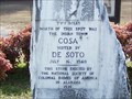 view gallery view galleryNE15.8 km | Cosa - Childersburg, AL in Alabama Historical Markers Cosa, Coosa, and Coca are all names for the same Indian villagee visited by DeSoto in 1540. The three names can be found on three historical markers within about three miles of this marker. posted by: hummerstation location: Alabama date approved: 01/11/2013 last visited: 08/26/2013 |
 view gallery view galleryNE15.8 km |  Indian Town Cosa Indian Town Cosa
in Signs of History This Sign of History is at the corner of US Hwy 231 and County Road 8 in Childersburg, Alabama. posted by: PeterNoG location: Alabama date approved: 03/01/2012 last visited: 01/09/2012 |
 view gallery view galleryW15.9 km |  Columbiana AL 35051 Columbiana AL 35051
in U.S. Post Offices This is the post office in Columbiana, Alabama. posted by: OHail location: Alabama date approved: 12/21/2011 last visited: 08/15/2014 |
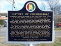 view gallery view galleryNE16.1 km | History of Childersburg - Childersburg, AL in Alabama Historical Markers Childersburg traces its heritage to the Coosa Indian village located in the area visited by DeSoto in the 1540s. posted by: hummerstation location: Alabama date approved: 01/11/2013 last visited: 08/31/2013 |
|