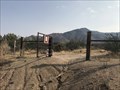
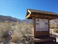
 view gallery view gallery W9.2 km W9.2 km
|   Pacific Crest Trail - Julian, CA Pacific Crest Trail - Julian, CA
in Long Distance Hiking Trails A trailhead for the Pacific Crest Trail near Julian, California. posted by:  bluesnote bluesnote location: California date approved: 01/16/2022 last visited: never |
 view gallery view galleryW9.2 km |  Pacific Crest Trail - Julian, CA Pacific Crest Trail - Julian, CA
in Hiking and walking trailheads A trailhead for the Pacific Crest Trail near Julian, California. posted by: bluesnote location: California date approved: 01/04/2022 last visited: never |
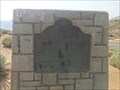
 view gallery view galleryW9.3 km |  Vallecito-Butterfield Stage Station - Shelter Valley, CA Vallecito-Butterfield Stage Station - Shelter Valley, CA
in Wagon Roads and Trails One of a few California State Historical Markers in northeastern San Diego County. posted by: bluesnote location: California date approved: 09/28/2021 last visited: never |
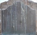
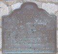 view gallery view galleryW9.3 km |  First Stage Departure on the Butterfield Stage Line First Stage Departure on the Butterfield Stage Line
in First of its Kind The first stage on the Butterfield Stage Line left St. Louis on September 15, 1858. posted by: brwhiz location: California date approved: 09/29/2013 last visited: 09/27/2021 |
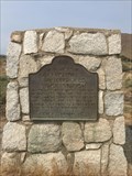 view gallery view galleryW9.3 km |  Vallecito-Butterfield Stage Station - Shelter Valley, CA Vallecito-Butterfield Stage Station - Shelter Valley, CA
in California Historical Markers One of a few California State Historical Markers in northeastern San Diego County. posted by: bluesnote location: California date approved: 10/09/2021 last visited: never |
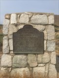 view gallery view galleryW9.3 km |  Vallecito-Butterfield Stage Station - Shelter Valley, CA Vallecito-Butterfield Stage Station - Shelter Valley, CA
in Cairns One of a few California State Historical Markers in northeastern San Diego County. posted by: bluesnote location: California date approved: 02/19/2022 last visited: never |
 view gallery view galleryW10.1 km |  San Felipe San Felipe
in E Clampus Vitus Historical Markers This E Clampus Vitus Marker is on a small rise above the Great Overland Stage Route of 1849 (County Road S-2) about 1 mile north of California Highway 78. posted by: brwhiz location: California date approved: 09/28/2013 last visited: 02/19/2021 |
 view gallery view gallery S10.3 km S10.3 km
| Pictograph Trail - Blair Canyon, CA in Hiking and walking trailheads The trailhead to the pictographs that are likely thousands of years old in Anza-Borrego State Park. posted by: bluesnote location: California date approved: 09/27/2021 last visited: never |
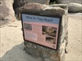 view gallery view galleryS10.3 km |  What do They Mean? - Blair Canyon, CA What do They Mean? - Blair Canyon, CA
in Signs of History The trailhead to the pictographs that are likely thousands of years old in Anza-Borrego State Park. posted by: bluesnote location: California date approved: 09/27/2021 last visited: never |
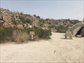
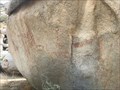
 view gallery view galleryS10.8 km |  Blair Valley Pictographs - Blair Valley, CA Blair Valley Pictographs - Blair Valley, CA
in Pictographs Pictographs that are likely thousands of years old in Anza Borrego State Park. It's a 1 mile hike from the trailhead, which requies a 4x4 to reach. posted by: bluesnote location: California date approved: 09/29/2021 last visited: never |
 view gallery view galleryS10.8 km |  Blair Valley Pictographs - Blair Valley, CA Blair Valley Pictographs - Blair Valley, CA
in New World Ancient Evidence Pictographs that are likely thousands of years old in Anza Borrego State Park. It's a 1 mile hike from the trailhead, which requies a 4x4 to reach. posted by: bluesnote location: California date approved: 10/11/2021 last visited: never |
 view gallery view galleryS10.8 km |  Blair Valley Pictographs - Blair Valley, CA Blair Valley Pictographs - Blair Valley, CA
in Official Local Tourism Attractions Pictographs that are likely thousands of years old in Anza Borrego State Park. It's a 1 mile hike from the trailhead, which requires a 4x4 to reach. posted by: bluesnote location: California date approved: 09/27/2021 last visited: never |
 view gallery view gallery SW12.4 km SW12.4 km
| Box Canyon - Hornblende Canyon, CA in California Historical Markers One of a few California State Historical Markers in northeastern San Diego County. posted by: bluesnote location: California date approved: 10/09/2021 last visited: never |
 view gallery view gallerySW12.4 km |  Box Canyon - Hornblende Canyon, CA Box Canyon - Hornblende Canyon, CA
in LDS Church History Sites One of a few California State Historical Markers in northeastern San Diego County. posted by: bluesnote location: California date approved: 09/27/2021 last visited: never |
 view gallery view gallerySW12.4 km | FIRST -- Road into Southern California - Hornblende Canyon, CA in First of its Kind One of a few California State Historical Markers in northeastern San Diego County. posted by: bluesnote location: California date approved: 09/27/2021 last visited: 09/27/2021 |
 view gallery view gallerySW12.4 km | Box Canyon - Hornblende Canyon, CA in Wagon Roads and Trails One of a few California State Historical Markers in northeastern San Diego County. posted by: bluesnote location: California date approved: 09/28/2021 last visited: never |
 view gallery view gallery N14.5 km N14.5 km
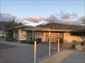
|  Steele/Burnand Anza-Borrego Desert Research Station - Borrego Springs, CA Steele/Burnand Anza-Borrego Desert Research Station - Borrego Springs, CA
in Wikipedia Entries A research station owned by the University of California and California State Parks, operated by UC Irvine in Borrego Springs, California. posted by: bluesnote location: California date approved: 02/25/2023 last visited: never |
 view gallery view galleryN14.5 km |  Steele/Burnand Anza-Borrego Desert Research Station - Borrego Springs, CA Steele/Burnand Anza-Borrego Desert Research Station - Borrego Springs, CA
in Guest Books A research station owned by the University of California and California State Parks, operated by UC Irvine in Borrego Springs, California. posted by: bluesnote location: California date approved: 02/25/2023 last visited: never |
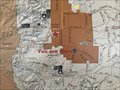 view gallery view galleryN14.5 km |  Steele/Burnand Anza-Borrego Desert Research Station "You are Here" Map - Borrego Springs, CA Steele/Burnand Anza-Borrego Desert Research Station "You are Here" Map - Borrego Springs, CA
in 'You Are Here' Maps A map inside the cafeteria at the Steele/Burnand Anza-Borrego Desert Research Station in Borrego Springs, California. posted by: bluesnote location: California date approved: 02/25/2023 last visited: never |
 view gallery view galleryN14.5 km |  Steele/Burnand Anza-Borrego Desert Research Station - Borrego Springs, CA Steele/Burnand Anza-Borrego Desert Research Station - Borrego Springs, CA
in LEED Buildings A research station owned by the University of California and California State Parks, operated by UC Irvine in Borrego Springs, California. posted by: bluesnote location: California date approved: 02/25/2023 last visited: never |
 view gallery view galleryN14.5 km |  Lake Urmia Salt Sediment - Borrego Springs, CA Lake Urmia Salt Sediment - Borrego Springs, CA
in Rock and Mineral Displays A specimen from Lake Urmia in Iran on display at the Steele/Burnand Anza-Borrego Desert Research Station in Borrego Springs, California. posted by: bluesnote location: California date approved: 02/25/2023 last visited: never |
 view gallery view galleryN14.5 km |  Steele/Burnand Anza-Borrego Desert Research Station - Borrego Springs, CA Steele/Burnand Anza-Borrego Desert Research Station - Borrego Springs, CA
in Research Institutes A research station owned by the University of California and California State Parks, operated by UC Irvine in Borrego Springs, California. posted by: bluesnote location: California date approved: 02/25/2023 last visited: never |
 view gallery view galleryN14.5 km |  Steele/Burnand Anza-Borrego Desert Research Station - 2015 - Borrego Springs, CA Steele/Burnand Anza-Borrego Desert Research Station - 2015 - Borrego Springs, CA
in Dated Architectural Structures Multifarious A research station owned by the University of California and California State Parks, operated by UC Irvine in Borrego Springs, California. posted by: bluesnote location: California date approved: 02/26/2023 last visited: never |
 view gallery view galleryN15.4 km |  Hellhole Canyon Hellhole Canyon
in Geological Devilish Locations The Hellhole Canyon area is in Anza Borrego State Park. There is a parking area and a trail up the canyon. posted by: TerryDad2 location: California date approved: 10/24/2006 last visited: 01/17/2011 |
 view gallery view galleryN15.9 km |  Borrego Springs, California 92004 Borrego Springs, California 92004
in U.S. Post Offices This Post Office is located at 2599 Country Club Road in Borrego Springs, California. posted by: brwhiz location: California date approved: 10/02/2013 last visited: 12/17/2013 |
|