 view gallery view gallery SW13.4 km SW13.4 km
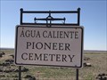
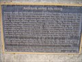
|   Agua Caliente Pioneer Cemetery - Agua Caliente, Arizona Agua Caliente Pioneer Cemetery - Agua Caliente, Arizona
in Worldwide Cemeteries The Agua Caliente Pioneer Cemetery is on a small hill on the south side of the Old Agua Caliente Highway. The cemetery has around 100 marked graves and a large number of unmarked graves. The oldest grave I located was 1880, Jesus Cruz. posted by:  T2D T2D location: Arizona date approved: 02/20/2020 last visited: never |
 view gallery view gallerySW13.7 km |  Agua Caliente, Arizona Agua Caliente, Arizona
in Ghost Towns Agua Caliente is listed as a ghost town. It was a exclusive resort circa 1895. It is 12 miles north of Sentinel, Arizona on a paved road. posted by: T2D location: Arizona date approved: 02/20/2020 last visited: never |
 view gallery view gallery E17.4 km E17.4 km
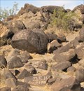
|  Painted Rock Petroglyph Site Painted Rock Petroglyph Site
in Pictographs At this location there are hundreds of petroglyphs scraped through the dark desert varnish of the tumbled rocks and boulders. posted by:  Miragee Miragee location: Arizona date approved: 06/26/2006 last visited: 02/07/2020 |
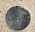
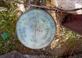
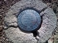
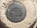 view gallery view galleryE17.5 km |  Painted Rock Historic Park Elevation Marker 80 GWM - Dendora Valley, AZ Painted Rock Historic Park Elevation Marker 80 GWM - Dendora Valley, AZ
in U.S. Benchmarks This elevation marker is at the entrance to the Painted Rock Historic Park. posted by: rjmcdonough1 location: Arizona date approved: 01/16/2020 last visited: never |
 view gallery view gallery S24.3 km S24.3 km
|  Sentinel, AZ Old Adobe house Sentinel, AZ Old Adobe house
in Unoccupied Buildings, Shacks, and Cabins Old Adobe House. Sentinel, AZ posted by: jdwest32 location: Arizona date approved: 05/19/2008 last visited: 02/07/2019 |
 view gallery view galleryS24.5 km | Old Stone house, Sentinel, AZ in Unoccupied Buildings, Shacks, and Cabins Old Stone house posted by: jdwest32 location: Arizona date approved: 05/19/2008 last visited: 02/07/2019 |
 view gallery view galleryS27 km | 744 in U.S. Benchmarks Unrecorded USGS Benchmark posted by: saguaroastro location: Arizona date approved: 12/19/2005 last visited: never |
 view gallery view gallery NE30.6 km NE30.6 km
|  Solitary Chimney - Arlington, AZ Solitary Chimney - Arlington, AZ
in Lonely Chimneys This chimney is a short way off the Aqua Caliente Road west of Arlington. posted by: rjmcdonough1 location: Arizona date approved: 06/03/2019 last visited: never |
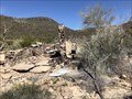
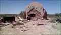
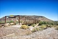
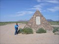 view gallery view gallerySW36.5 km |  Camp Horn Monument - Dateland, AZ Camp Horn Monument - Dateland, AZ
in U.S. National Register of Historic Places Little remains of Camp Horn but foundations and rock-lined walkways. But nearby still stands this stone pyramid, which was erected in memory of seven servicemen killed in a training accident. posted by: leadhiker location: Arizona date approved: 05/17/2010 last visited: 02/12/2023 |
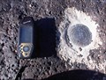
 view gallery view gallerySW42.2 km | Elevation Station 1956 - Dateland, AZ in U.S. Benchmarks This benchmark, with its attendant witness post is in the sand on the north side of old Highway 80 in Dateland. posted by: rjmcdonough1 location: Arizona date approved: 02/09/2023 last visited: never |
 view gallery view gallerySW42.2 km |  Dateland, AZ Dateland, AZ
in Wikipedia Entries Dateland is a census designated place in southwestern Arizona. posted by: rjmcdonough1 location: Arizona date approved: 01/01/2019 last visited: never |
 view gallery view gallerySW42.2 km |  Dateland, Arizona 85333 Dateland, Arizona 85333
in U.S. Post Offices The Dateland Post Office is located inside the Dateland Elementary School. posted by: rjmcdonough1 location: Arizona date approved: 01/14/2019 last visited: never |
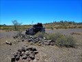
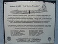 view gallery view gallerySW42.6 km |  Boeing B-50A The "Long Ranger" Boeing B-50A The "Long Ranger"
in Arizona Historical Markers A memorial in Dateland, Arizona to honor the dozen U.S. Air Force personnel who died in a Boeing B-50A bomber crash near Hyder in 1950 posted by: leadhiker location: Arizona date approved: 05/18/2010 last visited: 02/13/2017 |
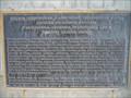 view gallery view gallerySW42.6 km | Hyder Divisional Camp-Horn Divisional Camp Desert Training Center in Arizona Historical Markers This was the largest Army base in the world covering some 18,000 square miles. It stretched from the outskirts of Pomona, California eastward to within 50 miles of Phoenix, Arizona, southward to the suburbs of Yuma, Arizona and northward into Nevada. posted by: leadhiker location: Arizona date approved: 05/18/2010 last visited: 04/13/2011 |
 view gallery view gallerySW42.6 km | Datelan Army Air Field in Arizona Historical Markers The airfield was established on 1 January 1943 as a United States Army Air Forces training airfield, being under the command of the 3037th Army Air Force Base Unit, AAF Western Flying Training Command. posted by: leadhiker location: Arizona date approved: 05/18/2010 last visited: 04/13/2011 |
 view gallery view galleryNE43 km | BLM Cadastral Survey Marker 1955 - Arlington, AZ in U.S. Benchmarks This marker sits at the edge of a corral in the desert outside Arlington. posted by: rjmcdonough1 location: Arizona date approved: 03/01/2019 last visited: never |
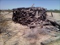
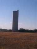 view gallery view galleryNE44.4 km |  Solitary Silo - Old US Highway 80 - Arizona Solitary Silo - Old US Highway 80 - Arizona
in Solitary Silos A very large solitary Silo off of Old Highway 80 and Agua Caliente Road. posted by: philbeer location: Arizona date approved: 08/21/2013 last visited: 08/21/2013 |
 view gallery view galleryE45.2 km | Gillespie Dam Highway Bridge - Gila Bend AZ in U.S. National Register of Historic Places The Gillespie Dam Highway Bridge was built in 1927 transformed the Yuma - Phoenix Highway into an all weather route, eliminating the crossing of the Gila River on the apron of the Gillespie Dam. posted by: nomadwillie location: Arizona date approved: 07/11/2018 last visited: never |
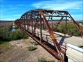 view gallery view galleryE45.7 km |  Gillespie Dam Bridge - Maricopa County, AZ Gillespie Dam Bridge - Maricopa County, AZ
in Truss Bridges The Gillespie Dam Bridge is a through truss bridge built in 1927. posted by: rjmcdonough1 location: Arizona date approved: 03/01/2019 last visited: never |
 view gallery view galleryE45.7 km | Gillespie Dam Bridge - Maricopa County, AZ in Wikipedia Entries The Gillespie Dam Bridge is a through truss bridge built in 1927. posted by: rjmcdonough1 location: Arizona date approved: 03/01/2019 last visited: never |
 view gallery view gallery NW47.5 km NW47.5 km
| 44LHL in U.S. Benchmarks side of road posted by: jdwest32 location: Arizona date approved: 01/26/2009 last visited: 02/12/2018 |
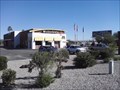
 view gallery view galleryE48 km |  Carl's - Gila Bend, AZ Carl's - Gila Bend, AZ
in Carl's Jr./Hardee's Restaurants Carl's - Gila Bend posted by: ToRo61 location: Arizona date approved: 10/29/2017 last visited: 01/04/2019 |
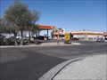
 view gallery view galleryE48 km |  Taco Bell - Gila Bend, AZ Taco Bell - Gila Bend, AZ
in Taco Bell Restaurants Taco Bell - Gila Bend posted by: ToRo61 location: Arizona date approved: 10/29/2017 last visited: 01/04/2019 |
 view gallery view galleryE48 km |  Love's Travel Center #296 - Gila Bend AZ Love's Travel Center #296 - Gila Bend AZ
in Truck Stops Although this isn't the largest truckstop I've ever been to, the facilities here are super-clean and nice, and a welcome place to pull into for a quick rest before moving on. posted by: Where's George location: Arizona date approved: 11/08/2013 last visited: 01/04/2019 |
 view gallery view galleryE48 km |  McDonald's #11680 - Gila Bend AZ McDonald's #11680 - Gila Bend AZ
in McDonald's Restaurants This McDonald's location sits in a busy area along Interstate 8 - busy, because this town basically exists as a rest stop and fuel stop for weary travellers. This is also the Greyhound stop in Gila Bend. posted by: Where's George location: Arizona date approved: 11/05/2013 last visited: 01/04/2019 |
|