 view gallery view gallery S5.6 km S5.6 km
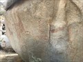
|   Blair Valley Pictographs - Blair Valley, CA Blair Valley Pictographs - Blair Valley, CA
in Pictographs Pictographs that are likely thousands of years old in Anza Borrego State Park. It's a 1 mile hike from the trailhead, which requies a 4x4 to reach. posted by:  bluesnote bluesnote location: California date approved: 09/29/2021 last visited: never |
 view gallery view galleryS5.6 km |  Blair Valley Pictographs - Blair Valley, CA Blair Valley Pictographs - Blair Valley, CA
in New World Ancient Evidence Pictographs that are likely thousands of years old in Anza Borrego State Park. It's a 1 mile hike from the trailhead, which requies a 4x4 to reach. posted by: bluesnote location: California date approved: 10/11/2021 last visited: never |
 view gallery view galleryS5.6 km |  Blair Valley Pictographs - Blair Valley, CA Blair Valley Pictographs - Blair Valley, CA
in Official Local Tourism Attractions Pictographs that are likely thousands of years old in Anza Borrego State Park. It's a 1 mile hike from the trailhead, which requires a 4x4 to reach. posted by: bluesnote location: California date approved: 09/27/2021 last visited: never |
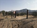
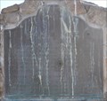
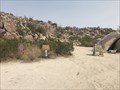 view gallery view galleryS5.6 km |  Pictograph Trail - Blair Canyon, CA Pictograph Trail - Blair Canyon, CA
in Hiking and walking trailheads The trailhead to the pictographs that are likely thousands of years old in Anza-Borrego State Park. posted by: bluesnote location: California date approved: 09/27/2021 last visited: never |
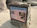 view gallery view galleryS5.6 km |  What do They Mean? - Blair Canyon, CA What do They Mean? - Blair Canyon, CA
in Signs of History The trailhead to the pictographs that are likely thousands of years old in Anza-Borrego State Park. posted by: bluesnote location: California date approved: 09/27/2021 last visited: never |
 view gallery view gallery SW11.3 km SW11.3 km
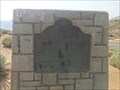
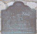
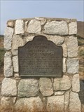
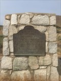
|  Box Canyon - Hornblende Canyon, CA Box Canyon - Hornblende Canyon, CA
in California Historical Markers One of a few California State Historical Markers in northeastern San Diego County. posted by: bluesnote location: California date approved: 10/09/2021 last visited: never |
 view gallery view gallerySW11.3 km |  FIRST -- Road into Southern California - Hornblende Canyon, CA FIRST -- Road into Southern California - Hornblende Canyon, CA
in First of its Kind One of a few California State Historical Markers in northeastern San Diego County. posted by: bluesnote location: California date approved: 09/27/2021 last visited: 09/27/2021 |
 view gallery view gallerySW11.3 km |  Box Canyon - Hornblende Canyon, CA Box Canyon - Hornblende Canyon, CA
in LDS Church History Sites One of a few California State Historical Markers in northeastern San Diego County. posted by: bluesnote location: California date approved: 09/27/2021 last visited: never |
 view gallery view gallerySW11.4 km |  Box Canyon - Hornblende Canyon, CA Box Canyon - Hornblende Canyon, CA
in Wagon Roads and Trails One of a few California State Historical Markers in northeastern San Diego County. posted by: bluesnote location: California date approved: 09/28/2021 last visited: never |
 view gallery view gallery W12.9 km W12.9 km
|  Pacific Crest Trail - Julian, CA Pacific Crest Trail - Julian, CA
in Long Distance Hiking Trails A trailhead for the Pacific Crest Trail near Julian, California. posted by: bluesnote location: California date approved: 01/16/2022 last visited: never |
 view gallery view galleryW12.9 km | Pacific Crest Trail - Julian, CA in Hiking and walking trailheads A trailhead for the Pacific Crest Trail near Julian, California. posted by: bluesnote location: California date approved: 01/04/2022 last visited: never |
 view gallery view galleryW13.2 km | Vallecito-Butterfield Stage Station - Shelter Valley, CA in Wagon Roads and Trails One of a few California State Historical Markers in northeastern San Diego County. posted by: bluesnote location: California date approved: 09/28/2021 last visited: never |
 view gallery view galleryW13.2 km | First Stage Departure on the Butterfield Stage Line in First of its Kind The first stage on the Butterfield Stage Line left St. Louis on September 15, 1858. posted by: brwhiz location: California date approved: 09/29/2013 last visited: 09/27/2021 |
 view gallery view galleryW13.2 km | Vallecito-Butterfield Stage Station - Shelter Valley, CA in California Historical Markers One of a few California State Historical Markers in northeastern San Diego County. posted by: bluesnote location: California date approved: 10/09/2021 last visited: never |
 view gallery view galleryW13.2 km |  Vallecito-Butterfield Stage Station - Shelter Valley, CA Vallecito-Butterfield Stage Station - Shelter Valley, CA
in Cairns One of a few California State Historical Markers in northeastern San Diego County. posted by: bluesnote location: California date approved: 02/19/2022 last visited: never |
 view gallery view galleryW14 km |  San Felipe San Felipe
in E Clampus Vitus Historical Markers This E Clampus Vitus Marker is on a small rise above the Great Overland Stage Route of 1849 (County Road S-2) about 1 mile north of California Highway 78. posted by: brwhiz location: California date approved: 09/28/2013 last visited: 02/19/2021 |
 view gallery view gallery N19.8 km N19.8 km
|  Steele/Burnand Anza-Borrego Desert Research Station - Borrego Springs, CA Steele/Burnand Anza-Borrego Desert Research Station - Borrego Springs, CA
in Wikipedia Entries A research station owned by the University of California and California State Parks, operated by UC Irvine in Borrego Springs, California. posted by: bluesnote location: California date approved: 02/25/2023 last visited: never |
 view gallery view galleryN19.8 km |  Steele/Burnand Anza-Borrego Desert Research Station - Borrego Springs, CA Steele/Burnand Anza-Borrego Desert Research Station - Borrego Springs, CA
in Guest Books A research station owned by the University of California and California State Parks, operated by UC Irvine in Borrego Springs, California. posted by: bluesnote location: California date approved: 02/25/2023 last visited: never |
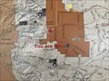 view gallery view galleryN19.8 km |  Steele/Burnand Anza-Borrego Desert Research Station "You are Here" Map - Borrego Springs, CA Steele/Burnand Anza-Borrego Desert Research Station "You are Here" Map - Borrego Springs, CA
in 'You Are Here' Maps A map inside the cafeteria at the Steele/Burnand Anza-Borrego Desert Research Station in Borrego Springs, California. posted by: bluesnote location: California date approved: 02/25/2023 last visited: never |
 view gallery view galleryN19.8 km |  Steele/Burnand Anza-Borrego Desert Research Station - Borrego Springs, CA Steele/Burnand Anza-Borrego Desert Research Station - Borrego Springs, CA
in LEED Buildings A research station owned by the University of California and California State Parks, operated by UC Irvine in Borrego Springs, California. posted by: bluesnote location: California date approved: 02/25/2023 last visited: never |
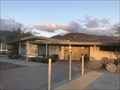 view gallery view galleryN19.8 km |  Steele/Burnand Anza-Borrego Desert Research Station - Borrego Springs, CA Steele/Burnand Anza-Borrego Desert Research Station - Borrego Springs, CA
in Research Institutes A research station owned by the University of California and California State Parks, operated by UC Irvine in Borrego Springs, California. posted by: bluesnote location: California date approved: 02/25/2023 last visited: never |
 view gallery view galleryN19.8 km |  Lake Urmia Salt Sediment - Borrego Springs, CA Lake Urmia Salt Sediment - Borrego Springs, CA
in Rock and Mineral Displays A specimen from Lake Urmia in Iran on display at the Steele/Burnand Anza-Borrego Desert Research Station in Borrego Springs, California. posted by: bluesnote location: California date approved: 02/25/2023 last visited: never |
 view gallery view galleryN19.8 km |  Steele/Burnand Anza-Borrego Desert Research Station - 2015 - Borrego Springs, CA Steele/Burnand Anza-Borrego Desert Research Station - 2015 - Borrego Springs, CA
in Dated Architectural Structures Multifarious A research station owned by the University of California and California State Parks, operated by UC Irvine in Borrego Springs, California. posted by: bluesnote location: California date approved: 02/26/2023 last visited: never |
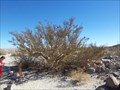 view gallery view gallery E20.1 km E20.1 km
|  Elephant Tree Elephant Tree
in Exceptional Trees The Elephant Tree is the last of its grove in the area. This rare tree is a desert adapted tree and is difficult to locate anywhere else. posted by: TerryDad2 location: California date approved: 10/23/2006 last visited: 02/26/2009 |
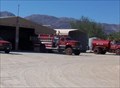 view gallery view gallery NE20.4 km NE20.4 km
|  Ocotillo Wells Fire Ocotillo Wells Fire
in Fire Fighting Vehicles You well just be looking at the entire fire department right here. posted by: TerryDad2 location: California date approved: 10/23/2006 last visited: 07/28/2007 |
|