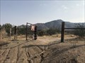
 view gallery view gallery SW4.2 km SW4.2 km
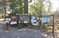
|   Box Canyon - Hornblende Canyon, CA Box Canyon - Hornblende Canyon, CA
in California Historical Markers One of a few California State Historical Markers in northeastern San Diego County. posted by:  bluesnote bluesnote location: California date approved: 10/09/2021 last visited: never |
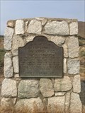
 view gallery view gallerySW4.2 km |  FIRST -- Road into Southern California - Hornblende Canyon, CA FIRST -- Road into Southern California - Hornblende Canyon, CA
in First of its Kind One of a few California State Historical Markers in northeastern San Diego County. posted by: bluesnote location: California date approved: 09/27/2021 last visited: 09/27/2021 |
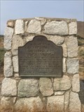
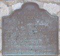
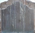
 view gallery view gallerySW4.2 km |  Box Canyon - Hornblende Canyon, CA Box Canyon - Hornblende Canyon, CA
in LDS Church History Sites One of a few California State Historical Markers in northeastern San Diego County. posted by: bluesnote location: California date approved: 09/27/2021 last visited: never |
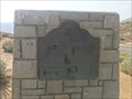 view gallery view gallerySW4.2 km |  Box Canyon - Hornblende Canyon, CA Box Canyon - Hornblende Canyon, CA
in Wagon Roads and Trails One of a few California State Historical Markers in northeastern San Diego County. posted by: bluesnote location: California date approved: 09/28/2021 last visited: never |
 view gallery view gallery E4.3 km E4.3 km
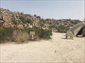
|  Pictograph Trail - Blair Canyon, CA Pictograph Trail - Blair Canyon, CA
in Hiking and walking trailheads The trailhead to the pictographs that are likely thousands of years old in Anza-Borrego State Park. posted by: bluesnote location: California date approved: 09/27/2021 last visited: never |
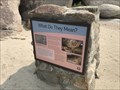 view gallery view galleryE4.3 km |  What do They Mean? - Blair Canyon, CA What do They Mean? - Blair Canyon, CA
in Signs of History The trailhead to the pictographs that are likely thousands of years old in Anza-Borrego State Park. posted by: bluesnote location: California date approved: 09/27/2021 last visited: never |
 view gallery view galleryE5.5 km |  Blair Valley Pictographs - Blair Valley, CA Blair Valley Pictographs - Blair Valley, CA
in Pictographs Pictographs that are likely thousands of years old in Anza Borrego State Park. It's a 1 mile hike from the trailhead, which requies a 4x4 to reach. posted by: bluesnote location: California date approved: 09/29/2021 last visited: never |
 view gallery view galleryE5.5 km |  Blair Valley Pictographs - Blair Valley, CA Blair Valley Pictographs - Blair Valley, CA
in Official Local Tourism Attractions Pictographs that are likely thousands of years old in Anza Borrego State Park. It's a 1 mile hike from the trailhead, which requires a 4x4 to reach. posted by: bluesnote location: California date approved: 09/27/2021 last visited: never |
 view gallery view galleryE5.5 km |  Blair Valley Pictographs - Blair Valley, CA Blair Valley Pictographs - Blair Valley, CA
in New World Ancient Evidence Pictographs that are likely thousands of years old in Anza Borrego State Park. It's a 1 mile hike from the trailhead, which requies a 4x4 to reach. posted by: bluesnote location: California date approved: 10/11/2021 last visited: never |
 view gallery view gallery NW9.5 km NW9.5 km
| Pacific Crest Trail - Julian, CA in Hiking and walking trailheads A trailhead for the Pacific Crest Trail near Julian, California. posted by: bluesnote location: California date approved: 01/04/2022 last visited: never |
 view gallery view galleryNW9.5 km |  Pacific Crest Trail - Julian, CA Pacific Crest Trail - Julian, CA
in Long Distance Hiking Trails A trailhead for the Pacific Crest Trail near Julian, California. posted by: bluesnote location: California date approved: 01/16/2022 last visited: never |
 view gallery view galleryNW9.7 km | Vallecito-Butterfield Stage Station - Shelter Valley, CA in Wagon Roads and Trails One of a few California State Historical Markers in northeastern San Diego County. posted by: bluesnote location: California date approved: 09/28/2021 last visited: never |
 view gallery view galleryNW9.7 km | Vallecito-Butterfield Stage Station - Shelter Valley, CA in California Historical Markers One of a few California State Historical Markers in northeastern San Diego County. posted by: bluesnote location: California date approved: 10/09/2021 last visited: never |
 view gallery view galleryNW9.7 km |  Vallecito-Butterfield Stage Station - Shelter Valley, CA Vallecito-Butterfield Stage Station - Shelter Valley, CA
in Cairns One of a few California State Historical Markers in northeastern San Diego County. posted by: bluesnote location: California date approved: 02/19/2022 last visited: never |
 view gallery view galleryNW9.7 km | First Stage Departure on the Butterfield Stage Line in First of its Kind The first stage on the Butterfield Stage Line left St. Louis on September 15, 1858. posted by: brwhiz location: California date approved: 09/29/2013 last visited: 09/27/2021 |
 view gallery view galleryNW10.6 km |  San Felipe San Felipe
in E Clampus Vitus Historical Markers This E Clampus Vitus Marker is on a small rise above the Great Overland Stage Route of 1849 (County Road S-2) about 1 mile north of California Highway 78. posted by: brwhiz location: California date approved: 09/28/2013 last visited: 02/19/2021 |
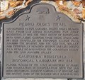 view gallery view gallery W13.5 km W13.5 km
| First Europeans to Enter Oriflamme Canyon in First of its Kind Colonel Pedro Fages and his troops the first Europeans to enter Oriflamme Canyon. posted by: brwhiz location: California date approved: 09/29/2013 last visited: 08/09/2014 |
 view gallery view galleryW14.2 km |  9 1/2 MPH at the KQ Ranch in Julian Ca. 9 1/2 MPH at the KQ Ranch in Julian Ca.
in Unusual Speed Limits An odd numbered speed limit sign in one of our favorite campgrounds posted by:  Moag Ohana Moag Ohana location: California date approved: 01/14/2008 last visited: never |
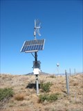 view gallery view galleryW15.6 km |  JULIANBIN_CS2004 CORS ARP JULIANBIN_CS2004 CORS ARP
in U.S. Benchmarks This is a GPS Continuously Operating Reference Station(CORS) This is a This is a Plate Boundary Observatory designated as DG8356 in the NGS DataBase. The coordinates shown are for the GPS station. posted by: MIG2 location: California date approved: 02/09/2012 last visited: never |
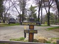
 view gallery view gallery S16.4 km S16.4 km
|  Laguna Campground Laguna Campground
in Campgrounds This popular Campground is located on Mount Laguna. posted by: brwhiz location: California date approved: 09/29/2013 last visited: never |
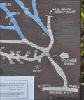 view gallery view galleryS16.4 km |  Laguna Campground Laguna Campground
in 'You Are Here' Maps You Are Here at the entrance to the Laguna Campground in the Laguna Mountains east of San Diego. posted by: brwhiz location: California date approved: 11/11/2013 last visited: never |
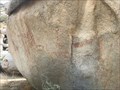
 S16.6 km | Laguna Mountain Bedrock Mortar in New World Ancient Evidence A distinct bedrock mortar was found near the "lagunas" on Laguna Mountain while hiking the area to find several Geocaches. posted by: Miragee location: California date approved: 07/05/2006 last visited: never |
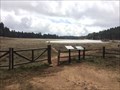 view gallery view galleryS16.7 km | Lake Laguna Trail - Mt. Laguna, CA in Hiking and walking trailheads The trailhead to California's oldest active geocache. posted by: bluesnote location: California date approved: 06/24/2017 last visited: 06/24/2017 |
 view gallery view galleryS16.7 km |  The Laguna Mountains Skipper - Mt. Laguna, CA The Laguna Mountains Skipper - Mt. Laguna, CA
in Flora and Fauna Information Signs A pair of two signs at the trailhead for the Laguna Meadows, where the oldest active geocache in California is hidden. posted by: bluesnote location: California date approved: 03/09/2017 last visited: 03/09/2017 |
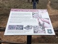
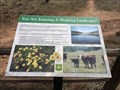 view gallery view galleryS16.7 km | You are Entering a Working Landscape - Mt. Laguna, CA in Flora and Fauna Information Signs A pair of two signs at the trailhead for the Laguna Meadows, where the oldest active geocache in California is hidden. posted by: bluesnote location: California date approved: 03/09/2017 last visited: 03/09/2017 |
|