 view gallery view gallery NW3.2 km NW3.2 km
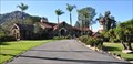
|   Castle, The ~ Ramona, California Castle, The ~ Ramona, California
in U.S. National Register of Historic Places The Castle, also known as the Amy Strong Castle or Mount Woodson Castle, was added to the National Register of Historic Places on March 30, 1978. posted by:  brwhiz brwhiz location: California date approved: 01/20/2011 last visited: 03/26/2011 |
 view gallery view gallery W3.4 km W3.4 km
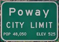
|  Poway, California, Population 48,050 Poway, California, Population 48,050
in Population Signs This combination elevation/population sign greets you as you travel south into Poway on California Highway 67. posted by: brwhiz location: California date approved: 06/07/2011 last visited: never |
 view gallery view galleryW3.4 km |  Poway, California - Elevation 525 Poway, California - Elevation 525
in Elevation Signs This combination elevation/population sign greets you as you travel south into Poway on California Highway 67. posted by: brwhiz location: California date approved: 06/07/2011 last visited: never |
 view gallery view galleryW3.4 km |  Poway, California Poway, California
in Wikipedia Entries Poway, on the northeastern edge of Dan Diego, is primarily a bedroom community for its larger neighbor. posted by: brwhiz location: California date approved: 06/08/2011 last visited: never |
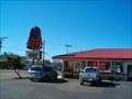 view gallery view gallery S5 km S5 km
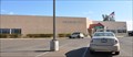
|  Arby's - Woodside Ave. -Lakeside -CA Arby's - Woodside Ave. -Lakeside -CA
in Arby's Restaurants Arby's Restaurant in Lakeside, CA. posted by:  Johnny_Quest Johnny_Quest location: California date approved: 01/26/2008 last visited: 04/23/2011 |
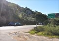
 view gallery view gallery SW5.1 km SW5.1 km
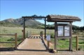
|  Iron Mountain Trailhead Entrance Arch Iron Mountain Trailhead Entrance Arch
in Freestanding Arches This freestanding wooden arch with metal decorative trim and name stands over the entrance to the Iron Mountain Trail east of Poway, California. posted by: brwhiz location: California date approved: 10/26/2012 last visited: never |
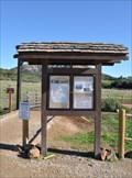 view gallery view gallerySW5.1 km |  Iron Mountain Trailhead Information Kiosk Iron Mountain Trailhead Information Kiosk
in Eagle Scout Project Sites This Eagle Scout Project is on the east side of California Highway 67 at the junction with Poway Road. posted by: brwhiz location: California date approved: 11/01/2012 last visited: never |
 view gallery view gallerySW5.1 km |  Iron Mountain Trailhead Iron Mountain Trailhead
in Hiking and walking trailheads The Iron Mountain Trailhead is on the east side of California Highway 67 at the junction with Poway Road several miles east of Poway, California. posted by: brwhiz location: California date approved: 10/28/2012 last visited: never |
 view gallery view gallery NE6.1 km NE6.1 km
|  Ramona, California 92065 Ramona, California 92065
in U.S. Post Offices This Post Office is located at 1444 Main Street in Ramona, California. posted by: brwhiz location: California date approved: 11/09/2011 last visited: never |
 view gallery view gallerySW6.1 km | Lakeside, California - Elevation 405 in Elevation Signs Lakeside, not far east of San Diego and less than halfway to the county's eastern edge, is nevertheless relegated to the status of being an "East County" community. posted by: brwhiz location: California date approved: 06/07/2011 last visited: 02/04/2012 |
 view gallery view gallerySW6.1 km | Lakeside, California in Wikipedia Entries Lakeside, not far east of San Diego and less than halfway to the county's eastern edge, is nevertheless relegated to the status of being an "East County" community. posted by: brwhiz location: California date approved: 06/08/2011 last visited: 02/04/2012 |
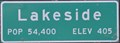 view gallery view gallerySW6.1 km | Lakeside, California ~ Population 54,400 in Population Signs Lakeside, not far east of San Diego and less than halfway to the county's eastern edge, is nevertheless relegated to the status of being an "East County" community. posted by: brwhiz location: California date approved: 06/07/2011 last visited: 02/04/2012 |
 view gallery view galleryNE7.4 km | Ramona Town Hall ~ Ramona, California in U.S. National Register of Historic Places The Ramona Town Hall, also known as Barnett Hall or Town Hall of Nuevo, was added to the National Register of Historic Places on September 6, 1994. posted by: brwhiz location: California date approved: 01/20/2011 last visited: never |
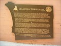 view gallery view galleryNE7.4 km |  Ramona Town Hall - Ramona, CA Ramona Town Hall - Ramona, CA
in E Clampus Vitus Historical Markers ECV plaque on the front of Ramona's Historic Town Hall. posted by: Johnny_Quest location: California date approved: 06/01/2010 last visited: 12/27/2010 |
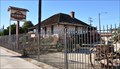
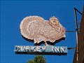 view gallery view galleryNE7.4 km |  Turkey Inn - Ramona, CA Turkey Inn - Ramona, CA
in Neon Signs Neon sign outside the Turkey Inn Tavern in Ramona, CA. posted by: Johnny_Quest location: California date approved: 06/04/2010 last visited: 04/25/2012 |
 view gallery view galleryNE7.6 km | Verlaque, Theophile, House - Ramona, California in U.S. National Register of Historic Places The Theophile Verlaque House was added to the National Register of Historic Places on August 7, 1991. posted by: brwhiz location: California date approved: 01/20/2011 last visited: never |
 view gallery view galleryNE7.6 km | Verlaque House - E Clampus Vitus - Ramona, CA in E Clampus Vitus Historical Markers This ECV marker dedicates an adobe home of a Ramona pioneer. posted by: Johnny_Quest location: California date approved: 01/29/2012 last visited: 12/27/2010 |
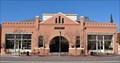
 view gallery view galleryNE7.6 km |  Ramona Mainstage - Ramona, California Ramona Mainstage - Ramona, California
in Concert Halls Ramona Mainstage is a multipurpose building on the main drag in Ramona whose history goes back over 70 years. posted by: =CCC= location: California date approved: 08/03/2016 last visited: 08/04/2016 |
 view gallery view galleryW8 km |  Harry W. Frame Dam, Lake Poway, CA Harry W. Frame Dam, Lake Poway, CA
in Water Dams This is the Harry W. Frame Dam in Lake Poway Park in Poway, CA. posted by: TucsonThompsen location: California date approved: 06/17/2010 last visited: never |
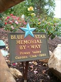 view gallery view galleryW8.4 km |  Lake Poway Park, Poway, CA Lake Poway Park, Poway, CA
in Blue Star Memorial Highway Markers Blue Star Memorial By-Way located in the Rose Garden of Lake Poway Park. posted by: Johnny_Quest location: California date approved: 05/08/2013 last visited: never |
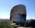 view gallery view galleryW8.4 km |  Tooth Rock Tooth Rock
in Simulacra Tooth Rock in Poway, CA north of San Diego. posted by: TucsonThompsen location: California date approved: 06/14/2010 last visited: 02/04/2012 |
 view gallery view gallery SE8.4 km SE8.4 km
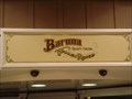
|  Barona Valley Ranch Resort & Casino Barona Valley Ranch Resort & Casino
in Casinos Located just 30 minutes outside of San Diego, Barona offers gaming action, unique dining, a hotel, and world-class golf. With a history dating back to the 1930s when the Barona Tribe established a small ranching community, the Barona Reservation has now blossomed into one of "California’s best casino's". posted by: PassingWind location: California date approved: 08/16/2005 last visited: 02/20/2013 |
 view gallery view gallerySE8.5 km |  Rumely Oilpull Tractor, Ramona, CA Rumely Oilpull Tractor, Ramona, CA
in Old Tractors This is a Rumely Oilpull tractor located at the Barona Casino on the Barona Indian Reservation in Ramona, CA. posted by: Johnny_Quest location: California date approved: 10/21/2007 last visited: never |
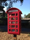 view gallery view galleryW9.8 km |  Little Free Library #6035 - Poway, CA Little Free Library #6035 - Poway, CA
in Free Community Book Exchanges A Little Free Library at 16285 Oak Creek Trail in Poway, CA. posted by: mojoloco7 location: California date approved: 10/28/2014 last visited: 03/21/2021 |
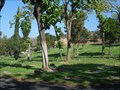 view gallery view galleryW10 km |  Dearborn Memorial Park - Poway, California Dearborn Memorial Park - Poway, California
in Worldwide Cemeteries A municipal cemetery in Poway, San Diego county, California. posted by: LeoGeo location: California date approved: 12/26/2012 last visited: never |
|