 view gallery view gallery E0.2 km E0.2 km
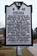
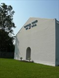
|   8-42 Howe Hall Plantation/Howe Hall Elementary School 8-42 Howe Hall Plantation/Howe Hall Elementary School
in South Carolina Historical Markers Located on Howe Hall Road east of Red Bank Road in front of the school, Goose Creek posted by:  Markerman62 Markerman62 location: South Carolina date approved: 01/04/2020 last visited: 12/31/2019 |
 view gallery view gallery W0.3 km W0.3 km
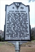
| 8-59 Goose Creek Bridge in South Carolina Historical Markers Located on Old State Road just north of Goose Creek Road, Goose Creek posted by: Markerman62 location: South Carolina date approved: 01/04/2020 last visited: 12/31/2019 |
 view gallery view gallery NW0.6 km NW0.6 km
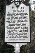
| 8-54 The Oaks in South Carolina Historical Markers Located at The Oaks Ave and Middleton Drive, Goose Creek posted by: Markerman62 location: South Carolina date approved: 01/04/2020 last visited: 12/31/2019 |
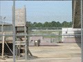
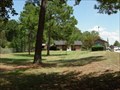
 view gallery view gallery S1 km S1 km
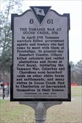
| 8-61 The Yamasee War at Goose Creek, 1715 in South Carolina Historical Markers Located in Foster Creek Park on Foster Creek Road, Goose Creek posted by: Markerman62 location: South Carolina date approved: 01/04/2020 last visited: 12/31/2019 |
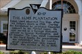 view gallery view galleryW2.9 km | HM 10-17 The Elms Plantation in South Carolina Historical Markers Near Ladson, SC posted by:  carolina1 carolina1 location: South Carolina date approved: 04/30/2008 last visited: 04/30/2008 |
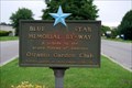
 view gallery view galleryNW2.9 km |  Hwy 176 and Westview Blvd, Goose Creek, South Carolina Hwy 176 and Westview Blvd, Goose Creek, South Carolina
in Blue Star Memorial Highway Markers Located at a busy intersection in Goose Creek, South Carolina. posted by:  mikemtn mikemtn location: South Carolina date approved: 10/15/2006 last visited: 09/19/2008 |
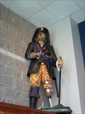 view gallery view galleryW3.5 km |  Mascot - Charleston Southern University Buccaneers Mascot - Charleston Southern University Buccaneers
in School Mascots Mascot - Charleston Southern University Buccaneers posted by: carolina1 location: South Carolina date approved: 07/12/2007 last visited: 07/13/2007 |
 view gallery view galleryS4 km | Eagle Landing Boulevard - Charleston, SC in Blue Star Memorial Highway Markers Blue Star in Charleston, South Carolina. posted by: carolina1 location: South Carolina date approved: 06/06/2008 last visited: 06/07/2008 |
 view gallery view galleryS5 km |  Courtyard Skatepark - North Charleston, South Carolina Courtyard Skatepark - North Charleston, South Carolina
in Skateparks Courtyard Skate park in N. Charleston, South Carolina. posted by: carolina1 location: South Carolina date approved: 08/23/2007 last visited: 09/16/2007 |
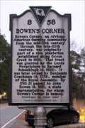 view gallery view gallery SE5.1 km SE5.1 km
| 8-58 Bowen's Corner in South Carolina Historical Markers Located on Foster Creek Road at Tanner Ford Boulevard, Hanahan posted by: Markerman62 location: South Carolina date approved: 01/04/2020 last visited: 12/31/2019 |
 view gallery view galleryW5.3 km |  I-26 Eastbound I-26 Eastbound
in Highway Rest Areas Located on I-26 Eastbound at mile marker 204 in the Goose Creek area just West of Charleston, South Carolina. posted by: mikemtn location: South Carolina date approved: 10/15/2006 last visited: 06/05/2010 |
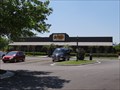 view gallery view galleryS5.5 km |  Cracker Barrel-7351 Mazyck Rd., N. Charleston, SC Cracker Barrel-7351 Mazyck Rd., N. Charleston, SC
in Cracker Barrel Restaurants Cracker Barrel-7351 Mazyck Road, North Charleston, SC 29406 posted by: walkingwildly location: South Carolina date approved: 04/23/2014 last visited: 03/13/2015 |
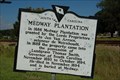 view gallery view gallery N6.4 km N6.4 km
| 8-19 Medway Plantation in South Carolina Historical Markers Located on US 52 about 3.2 miles North of Goose Creek. Erected in 1965 to replace old destroyed marker. posted by: mikemtn location: South Carolina date approved: 09/24/2006 last visited: 07/23/2007 |
 view gallery view galleryS6.9 km |  Charleston Air Force Base - SC Charleston Air Force Base - SC
in Military Installations Charleston Air Force Base, Charleston, South Carolina. posted by: carolina1 location: South Carolina date approved: 08/03/2007 last visited: 01/31/2012 |
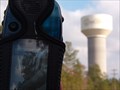 view gallery view galleryNW6.9 km |  Goose Creek Tower Goose Creek Tower
in Water Towers This is one of the water towers in Goose Creek, SC. It's nothnig fancy, but it is a VERY visible symbol in the city. posted by: JI Sandlappers location: South Carolina date approved: 01/02/2006 last visited: 07/23/2012 |
 E7.1 km |  Marrington Plantation Marrington Plantation
in Mountain Bike Trailheads Really nice trail for low country, very buffed and fast singletrack. Roots and bumps make the mostly flat trail interesting. posted by: susy1313 location: South Carolina date approved: 04/24/2006 last visited: 10/07/2008 |
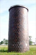 view gallery view galleryW7.4 km |  Highway 78 - Ladson, SC Highway 78 - Ladson, SC
in Solitary Silos Located in Ladson, SC. posted by: carolina1 location: South Carolina date approved: 09/04/2008 last visited: 07/23/2012 |
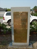
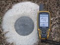 view gallery view galleryW7.6 km |  DM3253 - DAIMLER DM3253 - DAIMLER
in U.S. Benchmarks NGS PID DM3253. This is a Height Modernization Survey Station. Survey disk set in top of concrete monument, Stamping: DAIMLER 2010 by the South Carolina Geodetic Survey 2010. The Marker is equipped with a bar magnet. posted by: error650 location: South Carolina date approved: 02/03/2012 last visited: 02/01/2012 |
 view gallery view galleryS7.9 km |  Carolina Masonic Lodge No 375 Hanahan, South Carolina Carolina Masonic Lodge No 375 Hanahan, South Carolina
in Masonic Temples Carolina Masonic Lodge No 375 5929 Murray Drive, Hanahan, SC 29406. posted by: carolina1 location: South Carolina date approved: 08/18/2007 last visited: 09/16/2007 |
 view gallery view galleryNW8 km | I26 West Rest Area - Ladson, SC in Highway Rest Areas Rest area on I-26 Westbound, Ladson, SC. posted by: carolina1 location: South Carolina date approved: 08/25/2007 last visited: 07/23/2012 |
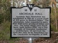 view gallery view gallery SW8.4 km SW8.4 km
| 18-12 Archdale Hall - North Charleston, SC in South Carolina Historical Markers The foundation located on Mansfield Drive is the remnants of Archdale Hall. The plantation was the longest family owned plantation in South Carolina. The area behind the house site contains numerous azaleas, lilies and other garden flora that were part of the garden in 1886 when the house was destroyed.
posted by: Martin 5 location: South Carolina date approved: 02/12/2009 last visited: 09/24/2010 |
 view gallery view galleryS8.7 km |  Veterans of Foreign War - Hanahan, SC Veterans of Foreign War - Hanahan, SC
in Non-Specific Veteran Memorials Monument for the Veterans of Foreign War posted by: carolina1 location: South Carolina date approved: 08/27/2007 last visited: 11/18/2008 |
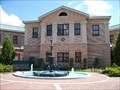 view gallery view galleryS8.7 km |  Hanahan, SC Hanahan, SC
in City and Town Halls Hanahan SC Municipal Complex posted by: carolina1 location: South Carolina date approved: 09/11/2007 last visited: 09/16/2007 |
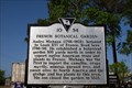 view gallery view galleryS8.9 km | 10-54 French Botanical Garden in South Carolina Historical Markers On Aviation Road posted by: carolina1 location: South Carolina date approved: 04/30/2008 last visited: 04/30/2008 |
 view gallery view galleryS9.2 km |  Charleston Animal Society Charleston Animal Society
in Humane Societies and Rescues Charleston Animal Society posted by: carolina1 location: South Carolina date approved: 09/04/2008 last visited: 09/04/2008 |
|