 view gallery view gallery SE2.6 km SE2.6 km
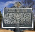
|   Providence Baptist Church - Lanett, AL Providence Baptist Church - Lanett, AL
in Alabama Historical Markers Located about 5 miles west of Lanett on Country Club Rd, this marker provides the early history of this church. posted by:  hoteltwo hoteltwo location: Alabama date approved: 02/09/2014 last visited: 01/11/2022 |
 view gallery view gallery N5.8 km N5.8 km
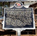
| New Hope Rosenwald School - Near Fredonia, AL in Alabama Historical Markers Located on County Rd 267, marker notes the building of one of the Sears CEO's Rosenwald schools for African-Americans. posted by: hoteltwo location: Alabama date approved: 03/12/2024 last visited: never |
 view gallery view gallery E8.4 km E8.4 km
|  The Doll House Grave The Doll House Grave
in Official Local Tourism Attractions An official landmark, the grave of Nadine Earle is a tribute from a father to his 4-year-old daughter who died in 1934. In Oakwood cemetary, 1st Ave. Lanette, Alabama. posted by: stsimpson location: Alabama date approved: 02/25/2007 last visited: 01/11/2009 |
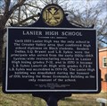 view gallery view galleryE8.5 km | Lanier High School - Lanett, AL in Alabama Historical Markers Located on Cherry Drive in Lanett, this marker describes the history of Lanier High School, now demolished. posted by: hoteltwo location: Alabama date approved: 02/09/2014 last visited: 01/10/2022 |
 view gallery view galleryE9.2 km |  Ocfuskooche Tallauhassee-GHM-141-10-Troup County Ocfuskooche Tallauhassee-GHM-141-10-Troup County
in Georgia Historical Markers State Line Road about 2.5 miles north of West Point posted by: Sprinterman location: Georgia date approved: 09/18/2008 last visited: 01/11/2022 |
 view gallery view galleryE9.5 km | Bluffton-Lanett, Alabama in Alabama Historical Markers Located at intersection of 1st Street and North Lanier Avenue this marker describes the beginnings & history of Lanett and one of the governors of Alabama. posted by: hoteltwo location: Alabama date approved: 01/06/2016 last visited: 01/11/2022 |
 view gallery view galleryE9.5 km |  Hardley Creek Park Playground Hardley Creek Park Playground
in Public Playgrounds Hardley Creek park playground posted by: Sharpslaw location: Georgia date approved: 12/17/2007 last visited: never |
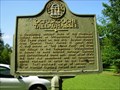
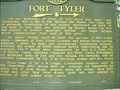 view gallery view galleryE9.7 km | Fort Tyler-GHM-141-2-Troup County in Georgia Historical Markers W 10th St at 6th Ave, West Point posted by: Sprinterman location: Georgia date approved: 09/18/2008 last visited: 03/04/2016 |
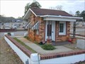
 view gallery view galleryE9.8 km |  Lanett, AL - 36863 Lanett, AL - 36863
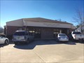
in U.S. Post Offices Located in the downtown area on 1st Street between South 1st Avenue and U.S. Highway 29. Population served by the Post Office has been declining. posted by: hoteltwo location: Alabama date approved: 04/15/2016 last visited: never |
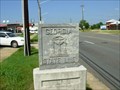 view gallery view galleryE9.8 km |  Georgia-Alabama State Line Marker-West Point, Georgia Georgia-Alabama State Line Marker-West Point, Georgia
in U.S. Historic Survey Stones and Monuments Monument located at the western edge of West Point, Georgia on US 29 across from the old depot. It marks the GA-AL state line. posted by: Sprinterman location: Georgia date approved: 09/17/2008 last visited: 02/09/2009 |
 view gallery view galleryE10 km |  Depot - Lanette, Alabama Depot - Lanette, Alabama
in Train Stations/Depots Train Depot posted by: Sharpslaw location: Alabama date approved: 12/18/2007 last visited: 01/11/2009 |
 view gallery view gallery W10 km W10 km
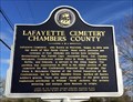
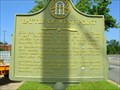
| Lafayette Cemetery - Lafayette, AL in Alabama Historical Markers Marker describes the beginnings of the Lafayette cemetery and some of its famous burials. posted by: hoteltwo location: Alabama date approved: 02/09/2014 last visited: 01/11/2022 |
 view gallery view galleryE10 km | Battle of West Point-April 16, 1865-GHM-141-1-Troup County in Georgia Historical Markers On US 29 median in downtown West Point posted by: Sprinterman location: Georgia date approved: 09/18/2008 last visited: 03/26/2001 |
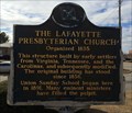 view gallery view galleryW10.5 km | The Lafayette Presbyterian Church - Lafayette, AL in Alabama Historical Markers Original wooden Presbyterian church building located at the corner of 1st Street and 2nd Avenue in Lafayette. posted by: hoteltwo location: Alabama date approved: 02/09/2014 last visited: 01/11/2022 |
 view gallery view galleryE10.5 km |  Subway - 10th Street - West Point, GA Subway - 10th Street - West Point, GA
in Subway Restaurants Subway located in a strip mall on E 10th Street (US 29) next to the bridge over the Chattahoochee River. posted by: Lat34North location: Georgia date approved: 01/16/2009 last visited: 01/11/2009 |
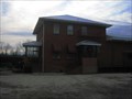
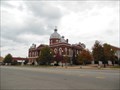 view gallery view galleryW10.5 km |  Chambers County Courthouse (CM2271) - LaFayette, AL Chambers County Courthouse (CM2271) - LaFayette, AL
in U.S. Benchmarks The statue on top of the dome is the focal point for the surveyors. posted by:  xptwo xptwo location: Alabama date approved: 11/12/2013 last visited: 01/14/2018 |
 view gallery view galleryW10.5 km | Muscogee Indians in Alabama Historical Markers Muscogee Indians posted by: Sharpslaw location: Alabama date approved: 12/15/2007 last visited: 01/11/2022 |
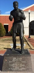 view gallery view galleryW10.5 km |  Joe Louis (Barrow) - Lafayette, AL Joe Louis (Barrow) - Lafayette, AL
in Statues of Historic Figures Born near Lafayette, Alabama Joe Louis Barrow was the world heavyweight boxing champion for eleven years. The statue was erected in the courthouse square in front of the new Chambers County Courthouse Annex in 2010. posted by: hoteltwo location: Alabama date approved: 02/13/2014 last visited: never |
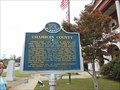 view gallery view galleryW10.5 km | Chambers County - Lafayette, AL in Alabama Historical Markers This marker located on the Chambers County Courthouse grounds gives some of the early history of the county. posted by: xptwo location: Alabama date approved: 11/02/2013 last visited: 01/11/2022 |
 view gallery view galleryW10.5 km |  Chamber County Town Clock Chamber County Town Clock
in Town Clocks Town Clock posted by: Sharpslaw location: Alabama date approved: 12/15/2007 last visited: 01/14/2018 |
 view gallery view galleryW10.8 km | Vines Funeral Home and Ambulance Service - LaFayette, AL in Alabama Historical Markers Located at the intersection of B Street and 1st Place SW in LaFayette, the marker notes one of the few professions open to African Americans during segregation. posted by: hoteltwo location: Alabama date approved: 08/06/2020 last visited: 01/11/2022 |
 view gallery view galleryN10.8 km |  Fredonia - East Alabama water district Fredonia - East Alabama water district
in Water Towers Water tower posted by: Sharpslaw location: Alabama date approved: 12/15/2007 last visited: 12/01/2013 |
 view gallery view galleryE10.8 km | Fort Tyler Cemetery-GHM-141-3-Troup County in Georgia Historical Markers US 29 at Pinewood Cemetery in West Point posted by: Sprinterman location: Georgia date approved: 09/18/2008 last visited: 03/26/2001 |
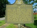 view gallery view galleryE10.8 km | Gen. Robert C. Tyler, C.S.A.-GHM-141-14-Troup County in Georgia Historical Markers US 29 at Pinewood Cemetery in West Point posted by: Sprinterman location: Georgia date approved: 09/18/2008 last visited: 03/26/2001 |
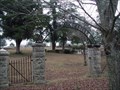 view gallery view galleryE10.8 km |  Pinewood Cemetery - West Point, GA Pinewood Cemetery - West Point, GA
in Worldwide Cemeteries Pinewood Cemetery on US 29 (Ave E) in West Point, GA. posted by: Lat34North location: Georgia date approved: 01/17/2009 last visited: 01/11/2009 |
|