 view gallery view gallery SW0 km SW0 km
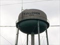
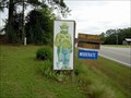
|   Culloden, Georgia Culloden, Georgia
in Water Towers Culloden, Georgia is located in Monroe County, Georgia posted by:  CrippledBlindSquirrel CrippledBlindSquirrel location: Georgia date approved: 09/16/2008 last visited: 07/26/2009 |
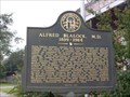 view gallery view gallerySW0 km |  Alfred Blalock, M.D. - Culloden, Monroe County, Georgia Alfred Blalock, M.D. - Culloden, Monroe County, Georgia
in Georgia Historical Markers This marker stands near the intersection of College St and Old Post Rd in Culloden, Georgia. Culloden is in Monroe County. posted by: CrippledBlindSquirrel location: Georgia date approved: 09/16/2008 last visited: 08/30/2022 |
 view gallery view gallery N0.3 km N0.3 km
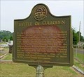
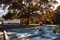
| Battle of Culloden-GHM 102-5-Monroe Co in Georgia Historical Markers At the cemetery on Church St in Culloden, off old US 341 posted by:  Sprinterman Sprinterman location: Georgia date approved: 08/01/2009 last visited: 08/30/2022 |
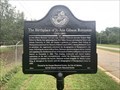 view gallery view galleryN1.4 km | The Birthplace of Jo Ann Gibson Robinson (1912-1992) GHS 102-2 - Culloden, GA in Georgia Historical Markers Located at Old US 341 and US 341 north of Culloden. posted by: Markerman62 location: Georgia date approved: 10/30/2022 last visited: never |
 view gallery view gallery W16.9 km W16.9 km
|  Smokey Bear in Upson County Georgia Smokey Bear in Upson County Georgia
in Smokey Bear Sign Sightings Smokey is standing watch at the Forest Service area at the foot of the fire tower. posted by: Sprinterman location: Georgia date approved: 10/24/2009 last visited: 11/17/2010 |
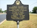 view gallery view galleryN17.1 km | Lamar Electric Membership Corporation-Lamar County in Georgia Historical Markers several miles south of Barnesville on U.S. 341 posted by: Sprinterman location: Georgia date approved: 07/27/2009 last visited: 08/30/2022 |
 view gallery view gallery NW17.2 km NW17.2 km
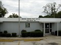
|  First Post Office at The Rock, Georgia First Post Office at The Rock, Georgia
in First of its Kind Sign marks the site of the first post office at The Rock posted by: OHail location: Georgia date approved: 03/15/2012 last visited: 04/30/2012 |
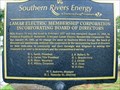 view gallery view galleryN17.2 km | Southern Rivers Energy-EMC-Lamar Co in Georgia Historical Markers US 341 about two miles south of Barnesville, at Southern Rivers Energy (the renamed Lamar EMC) posted by: Sprinterman location: Georgia date approved: 12/10/2009 last visited: 08/30/2022 |
 view gallery view galleryNW17.4 km |  The Rock United Methodist Church – The Rock, GA The Rock United Methodist Church – The Rock, GA
in Methodist Churches The Rock United Methodist Church is located on The Rock Road, south of GA 36, Rock, GA. posted by: Lat34North location: Georgia date approved: 11/30/2010 last visited: 11/17/2010 |
 view gallery view galleryNW17.4 km |  The Rock UME Church Cemetery – Rock, GA The Rock UME Church Cemetery – Rock, GA
in Churchyard Cemeteries The Rock UME Church Cemetery is located next to the church on The Rock Road, south of GA 36, Rock, GA. There are about 118 headstone located in this cemetery. posted by: Lat34North location: Georgia date approved: 11/30/2010 last visited: 11/17/2010 |
 view gallery view galleryNW17.4 km |  The Rock UME Church Cemetery – Rock, GA The Rock UME Church Cemetery – Rock, GA
in Worldwide Cemeteries The Rock UME Church Cemetery is located next to the church on The Rock Road, south of GA 36, Rock, GA. There are about 118 headstone located in this cemetery. posted by: Lat34North location: Georgia date approved: 12/01/2010 last visited: 11/17/2010 |
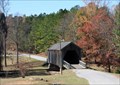 view gallery view gallerySW17.5 km |  Auchumpkee Creek Covered Bridge - Upson Co., GA Auchumpkee Creek Covered Bridge - Upson Co., GA
in Covered Bridges This bridge cross Auchumpkee Creek and is located on Allen Rd south of Thomaston, GA. posted by: Lat34North location: Georgia date approved: 11/18/2010 last visited: 02/25/2017 |
 view gallery view gallerySW17.5 km | Auchumpkee Creek Covered Bridge - Upson Co., GA in Georgia Historical Markers At the bridge on Allen Rd south of Thomaston, GA. posted by: Lat34North location: Georgia date approved: 11/19/2010 last visited: 02/25/2017 |
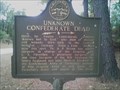 view gallery view galleryNW17.5 km | Unknown Confederate Dead, GHM 145-2, The Rock in Georgia Historical Markers Roadside Memorial/Historical Marker of 12 Unknown Confederate Soldiers near The Rock in Georgia. Roadside parking at site. posted by: Halen5150 location: Georgia date approved: 11/11/2006 last visited: 03/07/2012 |
 view gallery view galleryNW17.7 km |  The Rock, Georgia-30285 The Rock, Georgia-30285
in U.S. Post Offices A small rural town with an interesting name. posted by: Sprinterman location: Georgia date approved: 10/17/2009 last visited: 10/04/2009 |
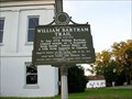
 view gallery view gallery SE17.7 km SE17.7 km
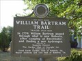
| William Bartram Trail in Georgia Historical Markers North Agency Street at City Hall; City of Roberta, Crawford County, Georgia posted by: tarvol_2000 location: Georgia date approved: 10/19/2005 last visited: 08/30/2022 |
 view gallery view gallerySE17.7 km |  William Bartram Trail Traced 1773-1777 - Roberta, GA William Bartram Trail Traced 1773-1777 - Roberta, GA
in Bartram Trail Historical Markers Located at East Agency Street and Hicks Road in front of city hall, Roberta posted by: Markerman62 location: Georgia date approved: 10/14/2022 last visited: never |
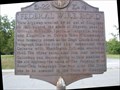
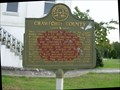 view gallery view gallerySE17.9 km | Crawford County-GHM 039-1-Crawford Co in Georgia Historical Markers at the old courthouse in Knoxville posted by: Sprinterman location: Georgia date approved: 10/17/2009 last visited: 11/30/2001 |
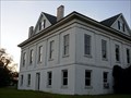 view gallery view gallerySE17.9 km |  Old Crawford County Courthouse-Knoxville, Georgia Old Crawford County Courthouse-Knoxville, Georgia
in Courthouses Located along US 80 in Knoxville, Georgia posted by: Sprinterman location: Georgia date approved: 10/17/2009 last visited: 08/30/2022 |
 view gallery view gallerySE17.9 km | Federal Wire Road-WPA 22 K-4-Crawford Co in Georgia Historical Markers Courthouse in Knoxville posted by: Sprinterman location: Georgia date approved: 10/17/2009 last visited: 06/28/2000 |
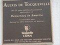 view gallery view gallerySE17.9 km | Alexis de Tocqueville in Georgia Historical Markers On Old Crawford County Courthouse, US Highway 80; Knoxville, Crawford County, Georgia posted by: tarvol_2000 location: Georgia date approved: 10/19/2005 last visited: 10/03/2009 |
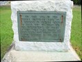 view gallery view gallerySE17.9 km |  Joanna Troutman Makes one of First "Lone Star" Flags-Knoxville, Georgia Joanna Troutman Makes one of First "Lone Star" Flags-Knoxville, Georgia
in Signs of History A plaque commemorating the making and presenting of one of the first Lone Star flags. posted by: Sprinterman location: Georgia date approved: 10/17/2009 last visited: 08/30/2022 |
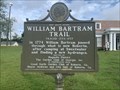
 view gallery view gallerySE17.9 km | William Bartram Trail Traced 1773-1777-GCG-Crawford Co in Georgia Historical Markers Rear of Courthouse in Knoxville posted by: Sprinterman location: Georgia date approved: 10/17/2009 last visited: 08/30/2022 |
 view gallery view gallerySE17.9 km | William Bartram Trail Traced 1773-1777-Knoxville, Georiga in Bartram Trail Historical Markers Behind the Crawford County Courthouse in Knoxville, Georiga posted by: Sprinterman location: Georgia date approved: 10/17/2009 last visited: 08/30/2022 |
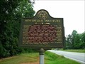 view gallery view gallery E19.8 km E19.8 km
| Montpelier Institute-GHM 102-3-Monroe Co in Georgia Historical Markers Ga 74 near the Bibb County line posted by: Sprinterman location: Georgia date approved: 08/01/2009 last visited: 07/26/2009 |
|