 view gallery view gallery N7.6 km N7.6 km
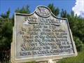
|   Fort Okfuskee (6 mi. west) - Jackson Gap, AL Fort Okfuskee (6 mi. west) - Jackson Gap, AL
in Alabama Historical Markers Marker placed to identify the location, 6 miles west on US Highway 280, of Fort Oksuskee. posted by:  hoteltwo hoteltwo location: Alabama date approved: 08/23/2013 last visited: 07/02/2004 |
 view gallery view gallery NW7.9 km NW7.9 km
|  Reunion Trail Wooden Bridge - Wind Creek State Park, AL Reunion Trail Wooden Bridge - Wind Creek State Park, AL
in Eagle Scout Project Sites Wooden bridge built in 2004. posted by:  hummerstation hummerstation location: Alabama date approved: 07/24/2017 last visited: never |
 view gallery view gallery E8.2 km E8.2 km
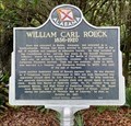
| William Carl Roeck - South of Dadeville, AL in Alabama Historical Markers Located along Stillwaters Hwy (AL-49), this maker describes the life of a notable German immigrant and politician. posted by: hoteltwo location: Alabama date approved: 06/01/2023 last visited: never |
 view gallery view gallery SW8.7 km SW8.7 km
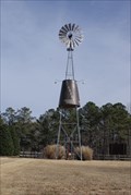
|  Russell Crossroads Windmill Russell Crossroads Windmill
in Windmills Decorative Windmill at the Russell Crossroads posted by: Blazer3T location: Alabama date approved: 06/17/2021 last visited: never |
 view gallery view gallerySW8.9 km |  Town Clock - Russell Lands, AL Town Clock - Russell Lands, AL
in Town Clocks Town Clocks for Russell Crossroad posted by: Blazer3T location: Alabama date approved: 10/10/2021 last visited: never |
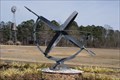 view gallery view gallerySW8.9 km |  Russell Crossroads Sundial, Alexander City, Alabama, U.S.A Russell Crossroads Sundial, Alexander City, Alabama, U.S.A
in Sundials Sundial in the Russell Crossroads Times Square posted by: Blazer3T location: Alabama date approved: 06/14/2021 last visited: never |
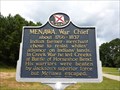 view gallery view galleryNW9.2 km | Menawa, War Chief - Alexander City, AL in Alabama Historical Markers Marker located near the entrance to Wind Creek State Park, describes the Indian warrior Menawa. posted by: hoteltwo location: Alabama date approved: 08/23/2013 last visited: 03/14/2015 |
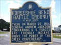 view gallery view galleryE9.3 km | Horseshoe Bend Battle Ground -12 Miles North in Alabama Historical Markers Marker at the intersection of U.S. Highway 280 and Alabama Route 49 leading to the Horseshoe Bend Battle Ground National Military Park. posted by: hoteltwo location: Alabama date approved: 08/23/2013 last visited: 09/06/2023 |
 view gallery view galleryE9.3 km |  Horseshoe Bend Battle Ground -12 Miles North - Daviston AL Horseshoe Bend Battle Ground -12 Miles North - Daviston AL
in Signs of History Marker at the intersection of U.S. Highway 280 and Alabama Route 49 leading to the Horseshoe Bend Battle Ground National Military Park. posted by: Don.Morfe location: Alabama date approved: 09/06/2023 last visited: 09/06/2023 |
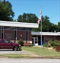
 view gallery view galleryE9.7 km |  Tallapoosa County Sheriff's Department Tallapoosa County Sheriff's Department
in Police Stations Sheriff's Department for Tallapoosa County, Alabama posted by: Blazer3T location: Alabama date approved: 06/15/2021 last visited: never |
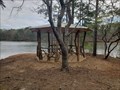 view gallery view gallery S9.8 km S9.8 km
|  The Perch - Dadeville, AL The Perch - Dadeville, AL
in Gazebos Beautiful Wood Gazebo at the end of Old Tree Trail posted by: Blazer3T location: Alabama date approved: 03/24/2020 last visited: never |
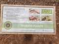 view gallery view galleryS10 km |  Invasive Plants Invasive Plants
in Flora and Fauna Information Signs Information Sign detailing Local Invasive Plants for This Area posted by: Blazer3T location: Alabama date approved: 04/06/2020 last visited: never |
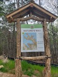 view gallery view galleryS10.1 km |  Nature's Way Trailhead Nature's Way Trailhead
in Hiking and walking trailheads Trail Head for the Nature's Way set of Trails. posted by: Blazer3T location: Alabama date approved: 04/13/2020 last visited: never |
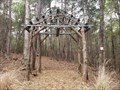 view gallery view galleryS10.1 km |  Nature's Way Trailhead Arch: Dadeville, AL Nature's Way Trailhead Arch: Dadeville, AL
in Freestanding Arches Arch at the entrance to the Nature's Way Trailhead posted by: Blazer3T location: Alabama date approved: 03/22/2020 last visited: never |
 view gallery view galleryS10.1 km | Naive American Heritage - Dadeville, AL USA in Signs of History An informational sign about the historical presence of Native Americans in the area. posted by: Blazer3T location: Alabama date approved: 04/04/2020 last visited: never |
 view gallery view galleryE10.3 km |  Dadeville Library - Dadeville, AL Dadeville Library - Dadeville, AL
in Libraries This public library in Dadeville, that also houses the Horseshoe Bend Regional Library System, is located on West Street at the end of West Cusseta Street. posted by: hoteltwo location: Alabama date approved: 09/04/2013 last visited: 04/02/2020 |
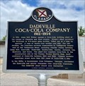 view gallery view galleryE10.3 km | Dadeville Coca-Cola Company - Dadeville, AL in Alabama Historical Markers About 5 years after Coca-Cola Co. made its trademarked contour 6.5 oz glass bottles, a Coca-Cola bottling plant was opened in Dadeville. The plant provided Coca-Cola to towns & cities all over the east side of the Tallapoosa River. posted by: hoteltwo location: Alabama date approved: 05/31/2023 last visited: 05/31/2023 |
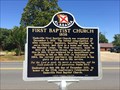 view gallery view galleryE10.3 km | First Baptist Church 1838 - Dadeville, Alabama in Alabama Historical Markers Marker is at the intersection of South Tallassee Street and Eufalla Street and describes the founding of the church and history of its subsequent buildings. posted by: hoteltwo location: Alabama date approved: 06/25/2016 last visited: 04/02/2020 |
 view gallery view galleryE10.3 km |  Man killed in fall from Dadeville water tower - Dadeville, AL Man killed in fall from Dadeville water tower - Dadeville, AL
in News Article Locations Tuscaloosa worker died from fall. posted by: Blazer3T location: Alabama date approved: 04/02/2020 last visited: never |
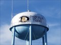
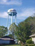 view gallery view galleryE10.3 km |  Dadeville Water Tower Dadeville Water Tower
in Water Towers Dadeville's Municipal Water Tower in Dadeville, AL posted by: Blazer3T location: Alabama date approved: 04/03/2020 last visited: never |
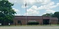
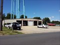 view gallery view galleryE10.3 km |  Dadeville Volunteer Fire Department Dadeville Volunteer Fire Department
in Firehouses A combined paid/ mostly volunteer city fire department with a single station and a very large coverage area in the oldest city in the county. posted by: hoteltwo location: Alabama date approved: 08/26/2013 last visited: 04/02/2020 |
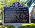 view gallery view galleryE10.3 km | Fletcher Napoleon Farrington, Sr. - Dadeville, AL in Alabama Historical Markers Marker is at the intersection of South Broadnax Street and Eufalla Street and notes the life and service of a local county agricultural agent and civic leader. posted by: hoteltwo location: Alabama date approved: 06/25/2016 last visited: 04/02/2020 |
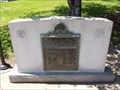
 view gallery view galleryE10.3 km |  Peace Officers Who Gave Their Lives In The Line Of Duty Peace Officers Who Gave Their Lives In The Line Of Duty
in Police Memorials Tallapoosa County's Fallen Officers Memorial posted by: Blazer3T location: Alabama date approved: 04/10/2020 last visited: never |
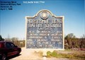
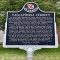 view gallery view galleryE10.5 km | Tallapoosa County - Dadeville, AL in Alabama Historical Markers The Creek Indian Nation ceded the land that formed Tallapoosa County after the Battle of Horseshoe Bend in 1814. Marker is located in front of the Tallapoosa County Courthouse. posted by: hoteltwo location: Alabama date approved: 05/31/2023 last visited: never |
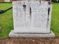
 view gallery view galleryE10.5 km |  World War I Memorial - Tallapoosa County, AL World War I Memorial - Tallapoosa County, AL
in World War I Memorials and Monuments Memorial near the County Courthouse, in Dadeville, remembering the sacrifice of those killed in World War I from Tallapoosa County. posted by: hoteltwo location: Alabama date approved: 08/24/2013 last visited: 04/11/2020 |
|