 view gallery view gallery NW4.3 km NW4.3 km
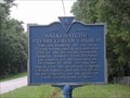
|   15-15 Salkehatchie Presbyterian Church 15-15 Salkehatchie Presbyterian Church
in South Carolina Historical Markers Marker on Hwy 17A between Walterboro and Yemassee posted by:  mikemtn mikemtn location: South Carolina date approved: 07/16/2006 last visited: 06/19/2002 |
 view gallery view gallery W4.7 km W4.7 km
|  Auldbrass Plantation - Yemassee, SC Auldbrass Plantation - Yemassee, SC
in Frank Lloyd Wright Designed Buildings Designed by Frank Lloyd Wright in 1939, the Auldbrass Plantation
is located in Yemassee, South Carolina. posted by:  carolina1 carolina1 location: South Carolina date approved: 09/10/2008 last visited: 08/05/2009 |
 view gallery view galleryW7.2 km |  Yemassee Marines Mural in Yemassee Yemassee Marines Mural in Yemassee
in Murals Mural depicting the history of the Marines in Yemassee posted by: mikemtn location: South Carolina date approved: 07/23/2006 last visited: 01/20/2017 |
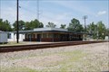 view gallery view galleryW7.2 km |  Yemassee South Carolina Amtrack Station Yemassee South Carolina Amtrack Station
in Train Stations/Depots The Yemassee South Carolina Amtrack Station posted by: mikemtn location: South Carolina date approved: 07/29/2006 last visited: 01/20/2017 |
 view gallery view galleryW7.2 km | Railroad Mural in Yemassee South Carolina in Murals Mural depicting the history of the Railroad in Yemassee posted by: mikemtn location: South Carolina date approved: 07/23/2006 last visited: 01/20/2017 |
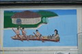 view gallery view galleryW7.4 km | Canoe in Yemasee South Carolina in Murals A canoe scene on a building in Yemassee posted by: mikemtn location: South Carolina date approved: 07/22/2006 last visited: 01/20/2017 |
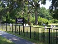 view gallery view galleryW8 km |  Jackson Family Cemetery - Yemassee, SC Jackson Family Cemetery - Yemassee, SC
in Worldwide Cemeteries Located on Yemassee Highway across from Fennell Elementary School. posted by: debbado location: South Carolina date approved: 08/20/2009 last visited: 10/13/2013 |
 view gallery view gallery S8.2 km S8.2 km
|  Old Sheldon Church Ruins - Sheldon SC Old Sheldon Church Ruins - Sheldon SC
in Freestanding Columns Having been burned down twice, once during the Revolutionary War and then again in the Civil War, it was left as a must see place during ones travals. posted by:  nomadwillie nomadwillie location: South Carolina date approved: 02/22/2013 last visited: 12/18/2022 |
 view gallery view galleryS8.2 km |  Old Sheldon Church Ruins - Sheldon SC Old Sheldon Church Ruins - Sheldon SC
in Preserved Architectural Remnants and Ruins Having been burned down twice, once during the Revolutionary War and then again in the Civil War, it was left as a must see place during ones travals. posted by: nomadwillie location: South Carolina date approved: 02/17/2013 last visited: 12/18/2022 |
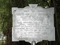 view gallery view galleryS8.2 km | 7-4 Ruins of Old Sheldon Church in South Carolina Historical Markers Marker at ruins posted by: mikemtn location: South Carolina date approved: 07/16/2006 last visited: 02/15/2020 |
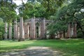 view gallery view galleryS8.2 km |  Sheldon Church Ruins Sheldon Church Ruins
in U.S. National Register of Historic Places The ruins of the Old Sheldon Church located between Gardens Corner and Yemassee South Carolina posted by: mikemtn location: South Carolina date approved: 07/18/2006 last visited: 12/18/2022 |
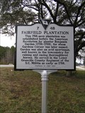 view gallery view galleryS10.1 km | 7-48 Fairfield Plantation in South Carolina Historical Markers Placed in 2014 by Beaufort County and the Friends of Gardens Corner. posted by: jhuoni location: South Carolina date approved: 03/08/2015 last visited: never |
 view gallery view galleryS10.1 km | 7-47 Gardens Corner in South Carolina Historical Markers Placed in 2014 by Beaufort County and the Friends of Gardens Corner. posted by: jhuoni location: South Carolina date approved: 03/08/2015 last visited: never |
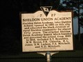 view gallery view galleryS10.3 km | 7-27 Sheldon Union Academy in South Carolina Historical Markers Marker beside Hwy 21 in Sheldon posted by: mikemtn location: South Carolina date approved: 07/19/2006 last visited: 12/17/2019 |
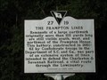 view gallery view gallery SW11.7 km SW11.7 km
| 27-19 The Frampton Lines in South Carolina Historical Markers Marker located at the entrance to the Lowcountry Visitors Center and Museum in Point South South Carolina. I just found out that the listed coordinates are wrong for this Marker. But it is located at the entrance to the Lowcountry Visitor center. posted by: mikemtn location: South Carolina date approved: 07/15/2006 last visited: 01/02/2021 |
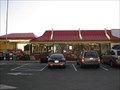 view gallery view gallerySW11.9 km |  Point South McDs - Yemassee, SC Point South McDs - Yemassee, SC
in McDonald's Restaurants Located just off I95. posted by: ChapterhouseInc location: South Carolina date approved: 05/02/2010 last visited: 08/19/2018 |
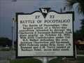 view gallery view gallerySW12.1 km | 27-22 Battle of Pocotaligo in South Carolina Historical Markers Marker in Point South in front of the Best Western Motel posted by: mikemtn location: South Carolina date approved: 07/15/2006 last visited: 10/13/2013 |
 view gallery view gallery N12.1 km N12.1 km
|  I 95 Southbound - Walterborough, SC I 95 Southbound - Walterborough, SC
in Highway Rest Areas Located on I95 for those heading to Savannah or beyond posted by: ChapterhouseInc location: South Carolina date approved: 08/13/2010 last visited: 11/13/2022 |
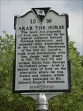 view gallery view galleryN12.1 km | 15-16 Arab the Horse and Hendersonville 15/16 in South Carolina Historical Markers A Marker on Hwy 17A between Walterboro and Yemassee posted by: mikemtn location: South Carolina date approved: 07/16/2006 last visited: 06/20/2002 |
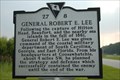 view gallery view gallerySW12.2 km | 27-8 Fighting Near Coosawhatchie & General Robert E. Lee in South Carolina Historical Markers Located about 1 mile W of Pocotaligo at Point South, intersection of I-96 and US 17 (E side). Erected by Point South Merchants Association in 1991. posted by: mikemtn location: South Carolina date approved: 09/11/2006 last visited: 10/13/2013 |
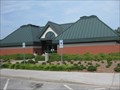
 view gallery view gallerySW12.9 km |  KOA Red Telephone Box - Point South, SC KOA Red Telephone Box - Point South, SC
in Payphones A red British telephone box located at the KOA campground in Point South, South Carolina. posted by: monkeys4ever location: South Carolina date approved: 04/02/2008 last visited: 10/12/2013 |
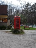 view gallery view gallerySW12.9 km |  KOA Red Telephone Box - Point South, SC KOA Red Telephone Box - Point South, SC
in Red Telephone Boxes This red telephone box is located at the KOA campground, Point South,South Carolina. posted by: monkeys4ever location: South Carolina date approved: 03/22/2008 last visited: 10/13/2013 |
 view gallery view gallery NE13.7 km NE13.7 km
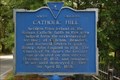
| 15-10 Catholic Hill in South Carolina Historical Markers Marker 15-10 Catholic Hill located on Road 41, 2.5 miles West of intersection with SC Hwy 303, South of Walterboro erected by Colleton County Historical Society in 1966. posted by: mikemtn location: South Carolina date approved: 08/20/2006 last visited: never |
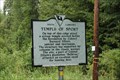 view gallery view gallery E14.8 km E14.8 km
| 15-13 Temple of Sport in South Carolina Historical Markers Marker 15-13 Temple of Sport located on US Hwy 17 West of it's junction with SC Hwy 303, between Ashepoo and Combahee Rivers, near Green Pond. Erected by Colleton County Historical Society in 1969. posted by: mikemtn location: South Carolina date approved: 08/13/2006 last visited: 04/09/2010 |
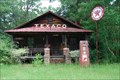 view gallery view galleryE15.3 km |  Texaco - 17S - Green Pond, SC Texaco - 17S - Green Pond, SC
in Vintage Gas Stations This old Texaco is located on 17S near Green Pond, SC. posted by: carolina1 location: South Carolina date approved: 09/14/2008 last visited: 04/09/2010 |
|